File:Jabel Luftbild 0209 Torsten Baetge.jpg
From Wikimedia Commons, the free media repository
Jump to navigation
Jump to search
![File:Jabel Luftbild 0209 Torsten Baetge.jpg](https://upload.wikimedia.org/wikipedia/commons/thumb/8/88/Jabel_Luftbild_0209_Torsten_Baetge.jpg/800px-Jabel_Luftbild_0209_Torsten_Baetge.jpg?20220605001447)
Size of this preview: 800 × 450 pixels. Other resolutions: 320 × 180 pixels | 640 × 360 pixels | 1,024 × 576 pixels | 1,280 × 720 pixels | 1,920 × 1,080 pixels.
Original file (1,920 × 1,080 pixels, file size: 1,009 KB, MIME type: image/jpeg)
File information
Structured data
Captions
Captions
Add a one-line explanation of what this file represents
Summary
[edit]DescriptionJabel Luftbild 0209 Torsten Baetge.jpg |
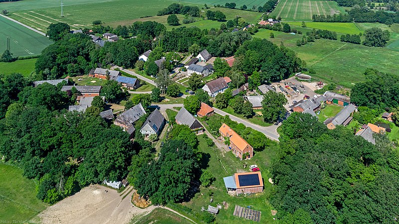
Deutsch: Luftbild von Jabel, einem Ortsteil der Stadt Lüchow (Wendland) im Landkreis Lüchow-Dannenberg. Westlich der durch das Dorf führenden Straße gruppieren sich sieben Hofstellen als halber Rundling (im Bild vorne/unten), auf der Ostseite der Straße sind zehn Hofstellen als Straßendorf angeordnet. Nach einem Brand auf der Ostseite des Rundlings am 12. Juli 1838 wurde dieser Teil in den folgenden zwei Jahren als Straßendorf wieder aufgebaut. |
Date | |
Source | Own work |
Author | Torsten Bätge, Hamburg |
Camera location | 52° 57′ 07″ N, 11° 04′ 41″ E ![]() ![]() | View this and other nearby images on: OpenStreetMap | ![]() |
---|
Licensing
[edit]![w:en:Creative Commons](https://upload.wikimedia.org/wikipedia/commons/thumb/7/79/CC_some_rights_reserved.svg/90px-CC_some_rights_reserved.svg.png)
![attribution](https://upload.wikimedia.org/wikipedia/commons/thumb/1/11/Cc-by_new_white.svg/24px-Cc-by_new_white.svg.png)
![share alike](https://upload.wikimedia.org/wikipedia/commons/thumb/d/df/Cc-sa_white.svg/24px-Cc-sa_white.svg.png)
This file is licensed under the Creative Commons Attribution-Share Alike 4.0 International license.
- You are free:
- to share – to copy, distribute and transmit the work
- to remix – to adapt the work
- Under the following conditions:
- attribution – You must give appropriate credit, provide a link to the license, and indicate if changes were made. You may do so in any reasonable manner, but not in any way that suggests the licensor endorses you or your use.
- share alike – If you remix, transform, or build upon the material, you must distribute your contributions under the same or compatible license as the original.
![]() |
Permission is granted to copy, distribute and/or modify this document under the terms of the GNU Free Documentation License, Version 1.2 or any later version published by the Free Software Foundation; with no Invariant Sections, no Front-Cover Texts, and no Back-Cover Texts. A copy of the license is included in the section entitled GNU Free Documentation License.http://www.gnu.org/copyleft/fdl.htmlGFDLGNU Free Documentation Licensetruetrue |
File history
Click on a date/time to view the file as it appeared at that time.
Date/Time | Thumbnail | Dimensions | User | Comment | |
---|---|---|---|---|---|
current | 00:14, 5 June 2022 | ![]() | 1,920 × 1,080 (1,009 KB) | Torsten Bätge (talk | contribs) | Uploaded with LrMediaWiki 1.7.2, LR 6.14 Win |
You cannot overwrite this file.
File usage on Commons
The following page uses this file:
File usage on other wikis
The following other wikis use this file:
- Usage on de.wikipedia.org
- Usage on de.wikivoyage.org
- Usage on www.wikidata.org
Metadata
This file contains additional information such as Exif metadata which may have been added by the digital camera, scanner, or software program used to create or digitize it. If the file has been modified from its original state, some details such as the timestamp may not fully reflect those of the original file. The timestamp is only as accurate as the clock in the camera, and it may be completely wrong.
Exposure time | 1/1,000 sec (0.001) |
---|---|
F-number | f/2.8 |
ISO speed rating | 100 |
Date and time of data generation | 15:16, 3 June 2022 |
Lens focal length | 4.5 mm |
Latitude | 52° 57′ 7″ N |
Longitude | 11° 4′ 41″ E |
Altitude | 120 meters above sea level |
Short title | Jabel |
Author | Torsten Bätge |
City shown | Lüchow (Wendland) |
Headline | Jabel |
Copyright holder | © 2022 Torsten Bätge. Alle Rechte vorbehalten. Die Nutzung des Fotos außerhalb der Vereinbarung ist honorarpflichtig gemäß |
Image title | Luftbild von Jabel, einem Ortsteil der Stadt Lüchow (Wendland) im Landkreis Lüchow-Dannenberg. Westlich der durch das Dorf führenden Straße gruppieren sich sieben Hofstellen als halber Rundling (im Bild vorne/unten), auf der Ostseite der Straße sind zehn Hofstellen als Straßendorf angeordnet. Nach einem Brand auf der Ostseite des Rundlings am 12. Juli 1838 wurde dieser Teil in den folgenden zwei Jahren als Straßendorf wieder aufgebaut. |
Horizontal resolution | 609 dpi |
Vertical resolution | 609 dpi |
Software used | Adobe Photoshop Lightroom 6.14 (Windows) |
File change date and time | 02:14, 5 June 2022 |
Y and C positioning | Centered |
Exif version | 2.3 |
Date and time of digitizing | 15:16, 3 June 2022 |
Meaning of each component |
|
APEX shutter speed | 9.9657843770174 |
APEX aperture | 2.9708536585366 |
APEX exposure bias | 0 |
Subject distance | 0 meters |
Supported Flashpix version | 1 |
Color space | sRGB |
File source | Digital still camera |
Focal length in 35 mm film | 24 mm |
Subject distance range | Unknown |
Direction of image | 35 |
GPS tag version | 2.3.0.0 |
IIM version | 4 |
Keywords |
|
Sublocation of city shown | Jabel |
Province or state shown | Niedersachsen |
Code for country shown | DEU |
Country shown | Deutschland |
Writer | Torsten Bätge |