File:Japan glaciation.png
Jump to navigation
Jump to search
Size of this preview: 533 × 600 pixels. Other resolutions: 213 × 240 pixels | 426 × 480 pixels | 1,003 × 1,129 pixels.
Original file (1,003 × 1,129 pixels, file size: 248 KB, MIME type: image/png)
Captions
Captions
Add a one-line explanation of what this file represents

|
This meteorology image could be re-created using vector graphics as an SVG file. This has several advantages; see Commons:Media for cleanup for more information. If an SVG form of this image is available, please upload it and afterwards replace this template with
{{vector version available|new image name}}.
It is recommended to name the SVG file “Japan glaciation.svg”—then the template Vector version available (or Vva) does not need the new image name parameter. |
Summary
[edit]
| Description |
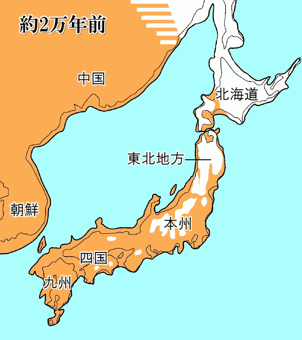
English: Map of the Periglacial Region in Japan at the Height of the Last Glaciation about 20,000 years ago
日本語: 約2万年前の氷河期最後の更新世後期の日本の高度地図 |
||
| Date | |||
| Source | Fig. 8 of Davison A, Chiba S, Barton NH, Clarke B. (2005) "Speciation and Gene Flow between Snails of Opposite Chirality" (in English). PLoS Biology 3 (9, e282). doi:10.1371/journal.pbio.0030282 | ||
| Author | Hanezuiro (talk) | ||
| Permission (Reusing this file) |
|
||
| Other versions |

|
File history
Click on a date/time to view the file as it appeared at that time.
| Date/Time | Thumbnail | Dimensions | User | Comment | |
|---|---|---|---|---|---|
| current | 23:53, 17 April 2010 | | 1,003 × 1,129 (248 KB) | Ras67 (talk | contribs) | cropped |
| 07:08, 22 September 2009 |  | 1,010 × 1,137 (212 KB) | Hanezuiro (talk | contribs) | 微修正 | |
| 15:38, 20 September 2009 |  | 1,010 × 1,137 (261 KB) | Hanezuiro (talk | contribs) | {{Information |Description={{en|1=Map of the Periglacial Region in Japan at the Height of the Last Glaciation about 20,000 years ago}} {{ja|1=約2万年前の氷河期最後の更新世後期の日本の高度地図}} |Source=Davison A, Chiba S, Bart |
You cannot overwrite this file.
File usage on Commons
The following page uses this file:
File usage on other wikis
The following other wikis use this file:
- Usage on hr.wikipedia.org
- Usage on ja.wikipedia.org
- Usage on ka.wikipedia.org
- Usage on ko.wikipedia.org
- Usage on outreach.wikimedia.org
- Usage on pt.wikipedia.org
- Usage on zh.wikipedia.org