File:Japan prefectures.svg
Jump to navigation
Jump to search

Size of this PNG preview of this SVG file: 482 × 600 pixels. Other resolutions: 193 × 240 pixels | 386 × 480 pixels | 617 × 768 pixels | 823 × 1,024 pixels | 1,646 × 2,048 pixels | 2,090 × 2,600 pixels.
Original file (SVG file, nominally 2,090 × 2,600 pixels, file size: 36 KB)
Captions
Captions
Add a one-line explanation of what this file represents
Summary[edit]
| Description |
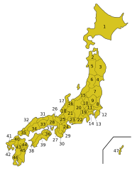
English: Map of the Prefectures of Japan.
|
|||||||||||||||||||||||||||||||||||||||||||||||||||||||||||||||||||||||||||||||||||||||||||||||||||||||||||||||||||||||||||||||||||||||||||||
| Date | ||||||||||||||||||||||||||||||||||||||||||||||||||||||||||||||||||||||||||||||||||||||||||||||||||||||||||||||||||||||||||||||||||||||||||||||
| Source |
Own work based on: Japan prefectures.png This vector image includes elements that have been taken or adapted from this file: |
|||||||||||||||||||||||||||||||||||||||||||||||||||||||||||||||||||||||||||||||||||||||||||||||||||||||||||||||||||||||||||||||||||||||||||||
| Author |
Vector: |
Licensing[edit]
I, the copyright holder of this work, hereby publish it under the following license:
| This file is made available under the Creative Commons CC0 1.0 Universal Public Domain Dedication. | |
| The person who associated a work with this deed has dedicated the work to the public domain by waiving all of their rights to the work worldwide under copyright law, including all related and neighboring rights, to the extent allowed by law. You can copy, modify, distribute and perform the work, even for commercial purposes, all without asking permission.
|
File history
Click on a date/time to view the file as it appeared at that time.
| Date/Time | Thumbnail | Dimensions | User | Comment | |
|---|---|---|---|---|---|
| current | 07:45, 15 August 2021 | | 2,090 × 2,600 (36 KB) | Andreasl01 (talk | contribs) | Moved some of the lines and numbers slightly |
| 07:06, 15 August 2021 |  | 2,090 × 2,600 (36 KB) | Andreasl01 (talk | contribs) | Split lines into separate paths to make them easier to edit | |
| 22:06, 7 August 2021 |  | 2,090 × 2,600 (36 KB) | Andreasl01 (talk | contribs) | {{Information |Description={{en|1=SVG version of {{F|Japan_prefectures.png}}}} |Source=Own work based on {{F|Japan_prefectures.png}}, using code from {{F|Regions_and_Prefectures_of_Japan.svg}} |Date=2021-08-08 |Author=Andreasl01 |Permission= |other_versions= }} |
You cannot overwrite this file.
File usage on Commons
The following 25 pages use this file:
- File:Japan prefectures.png
- Category:1948 aerial photographs of Japan
- Category:1977 aerial photographs of Japan
- Category:1978 aerial photographs of Japan
- Category:1979 aerial photographs of Japan
- Category:1984 aerial photographs of Japan
- Category:1989 aerial photographs of Japan
- Category:2005 aerial photographs of Japan
- Category:2006 aerial photographs of Japan
- Category:2007 aerial photographs of Japan
- Category:2008 aerial photographs of Japan
- Category:2009 aerial photographs of Japan
- Category:2010 aerial photographs of Japan
- Category:2011 aerial photographs of Japan
- Category:2012 aerial photographs of Japan
- Category:2013 aerial photographs of Japan
- Category:2015 aerial photographs of Japan
- Category:2016 aerial photographs of Japan
- Category:2017 aerial photographs of Japan
- Category:2018 aerial photographs of Japan
- Category:2019 aerial photographs of Japan
- Category:2020 aerial photographs of Japan
- Category:2021 aerial photographs of Japan
- Category:2022 aerial photographs of Japan
- Category:2023 aerial photographs of Japan