File:Jedlińsk (gmina) location map.png
Jump to navigation
Jump to search

Size of this preview: 601 × 600 pixels. Other resolutions: 241 × 240 pixels | 481 × 480 pixels | 957 × 955 pixels.
Original file (957 × 955 pixels, file size: 244 KB, MIME type: image/png)
Captions
Captions
Add a one-line explanation of what this file represents
| Description |
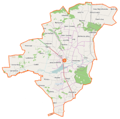
Polski: Mapa gminy Jedlińsk, Polska
English: Map of Gmina Jedlińsk, Poland |
|||||||||
| Date | ||||||||||
| Source | You may find a page on the OpenStreetMap wiki page for Jedlińsk (gmina) | |||||||||
| Creator |
OpenStreetMap contributors OpenStreetMap contributors |
|||||||||
| Permission (Reusing this file) |
OpenStreetMap data is available under the Open Database License (details). Map tiles are licensed under the Creative Commons Attribution-ShareAlike 2.0 license (CC-BY-SA 2.0).
This file is licensed under the Creative Commons Attribution-Share Alike 2.0 Generic license.
|
|||||||||
| Geotemporal data | ||||||||||
| Bounding box |
|
|||||||||
| Georeferencing | If inappropriate please set warp_status = skip to hide. | |||||||||
File history
Click on a date/time to view the file as it appeared at that time.
| Date/Time | Thumbnail | Dimensions | User | Comment | |
|---|---|---|---|---|---|
| current | 13:50, 2 October 2014 | | 957 × 955 (244 KB) | VanWiel (talk | contribs) | {{OpenStreetMap | name = Jedlińsk (gmina) | location = Jedlińsk (gmina) | description = {{pl|Mapa gminy Jedlińsk, Polska}} {{en|Map of Gmina Jedlińsk, Poland}} | top = 51.5946 | left = 20.9794... |
You cannot overwrite this file.
File usage on Commons
There are no pages that use this file.
File usage on other wikis
The following other wikis use this file:
- Usage on de.wikipedia.org
- Usage on fr.wikipedia.org
- Usage on pl.wikipedia.org
- Jedlińsk (gmina)
- Wola Gutowska
- Jedlińsk
- Bierwce
- Bierwiecka Wola
- Czarny Ług
- Klwatka Szlachecka
- Klwaty
- Mokrosęk
- Nowe Zawady
- Płasków
- Stare Zawady
- Urbanów
- Wsola
- Górna Wola (województwo mazowieckie)
- Gutów (województwo mazowieckie)
- Jeziorno (województwo mazowieckie)
- Józefówek (województwo mazowieckie)
- Kamińsk (województwo mazowieckie)
- Marcelów (Wsola)
- Wielogóra (województwo mazowieckie)
- Wierzchowiny (województwo mazowieckie)
- Boża Wola (powiat radomski)
- Godzisz (Bierwce)
- Janki (powiat radomski)
- Jankowice (powiat radomski)
- Jedlanka (powiat radomski)
- Kruszyna (powiat radomski)
- Lisów (powiat radomski)
- Ludwików (powiat radomski)
- Narty (powiat radomski)
- Nowa Wola (powiat radomski)
- Piaseczno (powiat radomski)
- Piastów (powiat radomski)
- Romanów (gmina Jedlińsk)
- Lotnisko Radom-Piastów
- Kościół Apostołów Piotra i Andrzeja w Jedlińsku
- Piaski (Jedlińsk)
- Bród (Gutów)
- Budki Wierzchowskie
- Czarna Rola (Jedlanka)
- Gryzów
- Józefów (gmina Jedlińsk)
- Kępiny (Jedlanka)
- Moczydło (Janki)
- Obózek
- Kruszyna (przystanek kolejowy)
- Wola Bierwiecka
View more global usage of this file.
_location_map.png)
_location_map.png&oldid=519968255)