File:John Harris, A map of the fourty years travels of the Israelites out of Egypt through the Red Sea & the wilderness into the Land of Promise (FL69134069 2368603).jpg
Jump to navigation
Jump to search

Size of this preview: 800 × 509 pixels. Other resolutions: 320 × 204 pixels | 640 × 407 pixels | 1,024 × 652 pixels | 1,280 × 815 pixels | 2,560 × 1,629 pixels | 11,978 × 7,622 pixels.
Original file (11,978 × 7,622 pixels, file size: 133.82 MB, MIME type: image/jpeg)
Captions
Captions
Add a one-line explanation of what this file represents
Summary
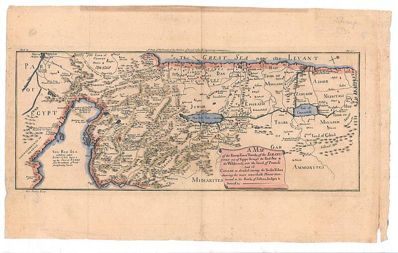
[edit]| John Harris: A map of the fourty years travels of the Israelites out of Egypt through the Red Sea & the wilderness into the Land of Promise
( |
||||||||||||||||||||||||
|---|---|---|---|---|---|---|---|---|---|---|---|---|---|---|---|---|---|---|---|---|---|---|---|---|
| Artist | ||||||||||||||||||||||||
| Title |
A map of the fourty years travels of the Israelites out of Egypt through the Red Sea & the wilderness into the Land of Promise |
|||||||||||||||||||||||
| Description |
A map of the fourty years travels of the Israelites out of Egypt through the Red Sea & the wilderness into the Land of Promise. And of Canaan as divided among the Twelve Tribes shewing the more remarkable in the Books of Joshua Judges & Samuel & c . I.Harris Sculp. |
|||||||||||||||||||||||
| Language | English | |||||||||||||||||||||||
| Publication date | 1720 possibly | |||||||||||||||||||||||
| Dimensions | 178 × 430 mm (7 × 16.92 in) | |||||||||||||||||||||||
| Collection |
|
|||||||||||||||||||||||
| Current location |
|
|||||||||||||||||||||||
| Place of publication | London | |||||||||||||||||||||||
| search Merhav catalog | London | |||||||||||||||||||||||
| Notes | Copperplat; Probably from an English Bible, published in 18th century. Book III, p.91. The map is drawn after Visscher | |||||||||||||||||||||||
| IE PID | IE69134067 | |||||||||||||||||||||||
| Rosetta filename | FL69134069 | |||||||||||||||||||||||
| NNL item ID (P3959) | 990023686030205171 | |||||||||||||||||||||||
| search Merhav catalog | English, John Harris | |||||||||||||||||||||||
| search Merhav catalog | Exodus, TheITwelve tribes of IsraelMaps | |||||||||||||||||||||||
| Source/Photographer |
|
|||||||||||||||||||||||
| Other versions | ||||||||||||||||||||||||
| Jpg / Tif version |
|
|||||||||||||||||||||||

.jpg)

.jpg&action=edit§ion=1)
Licensing
[edit].jpg&action=edit§ion=2)
The copyright situation of this work is theoretically uncertain, because in the country of origin copyright lasts 70 years after the death of the author, and the date of the author's death is unknown. However, the date of creation of the work was over 120 years ago, and it is thus a reasonable assumption that the copyright has expired (see here for the community discussion). Do not use this template if the date of death of the author is known.
| |
| This file has been identified as being free of known restrictions under copyright law, including all related and neighboring rights. | |
File history
Click on a date/time to view the file as it appeared at that time.
| Date/Time | Thumbnail | Dimensions | User | Comment | |
|---|---|---|---|---|---|
| current | 13:46, 28 July 2023 | | 11,978 × 7,622 (133.82 MB) | Geagea (talk | contribs) | pattypan 22.03 |
You cannot overwrite this file.
File usage on Commons
The following page uses this file:
.jpg&oldid=787624977)