File:John Smith 1624 map of Bermuda with Forts 01.jpg
Zur Navigation springen
Zur Suche springen

Größe dieser Vorschau: 766 × 600 Pixel. Weitere Auflösungen: 307 × 240 Pixel | 613 × 480 Pixel | 981 × 768 Pixel | 1.280 × 1.003 Pixel | 1.370 × 1.073 Pixel.
Originaldatei (1.370 × 1.073 Pixel, Dateigröße: 1,39 MB, MIME-Typ: image/jpeg)
Bildtexte
Kurzbeschreibungen
Ergänze eine einzeilige Erklärung, was diese Datei darstellt.
Beschreibung
[Bearbeiten]
| Beschreibung |
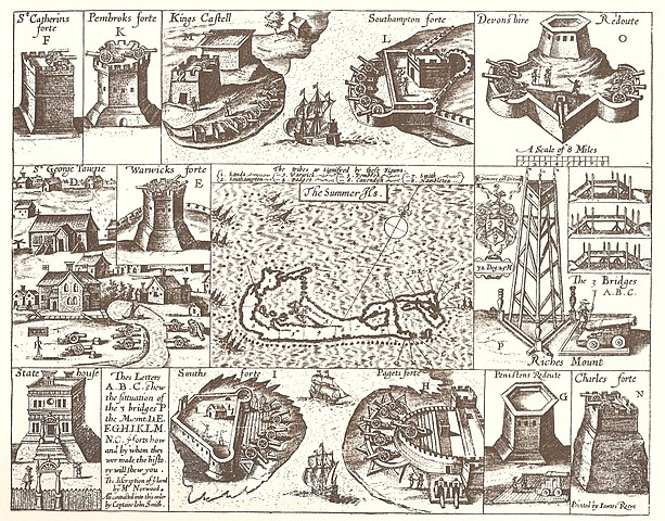
English: 1624 Map of Bermuda, with illustrations of fortifications and importand sites, including St. George's, Bermuda (the town), the State House, Bermuda, and the Castle Islands Fortifications, Bermuda |
| Datum | |
| Quelle | The Generall Historie of Virginia, New-England, and the Summer Isles, by Captain John Smith of Jamestown, printed by I.D and I. H. for Michael Sparkes, 1624. Other editions 1625, 1626, 1627, 1631, and 1632. |
| Urheber | Printed by James Reeve |
Lizenz
[Bearbeiten]
|
Dieses Werk ist gemeinfrei, weil seine urheberrechtliche Schutzfrist abgelaufen ist. | |
| Es wurde festgestellt, dass diese Datei frei von bekannten Beschränkungen durch das Urheberrecht ist, alle verbundenen und verwandten Rechte eingeschlossen. | |
| Bildnotizen | Diese Datei ist annotiert: Betrachte diese auf Commons. |
Dateiversionen
Klicke auf einen Zeitpunkt, um diese Version zu laden.
| Version vom | Vorschaubild | Maße | Benutzer | Kommentar | |
|---|---|---|---|---|---|
| aktuell | 17:39, 10. Feb. 2008 | | 1.370 × 1.073 (1,39 MB) | Aodhdubh (Diskussion | Beiträge) | {{Information |Description=1624 Map of Bermuda, with illustrations of fortifications and importand sites, including St. George's Town, the State House, and the [[Castle Islands Fortifications, Bermuda |
Du kannst diese Datei nicht überschreiben.
Dateiverwendung
Die folgenden 2 Seiten verwenden diese Datei:
Globale Dateiverwendung
Die nachfolgenden anderen Wikis verwenden diese Datei:
- Verwendung auf ar.wikipedia.org
- Verwendung auf en.wikipedia.org
- Church of England
- Militia
- History of Bermuda
- Military of Bermuda
- John Smith (explorer)
- Fortification
- Robert Rich, 2nd Earl of Warwick
- Sea Venture
- Coastal artillery
- William Sayle
- County surveyor
- Bermuda Militia (1612–1815)
- Bermuda Militia (1612–1687)
- List of World Heritage Sites in the United Kingdom
- Architecture of Bermuda
- Castle Islands Fortifications, Bermuda
- State House, Bermuda
- Militia (England)
- English overseas possessions in the Wars of the Three Kingdoms
- St. Peter's Church, St. George's
- Coastal defence and fortification
- Bermuda Garrison
- User:DadrianT,Esq/County Surveyor draft page
- Fort St. Catherine
- Historic Town of St George and Related Fortifications, Bermuda
- Militia (British Empire)
- Fort George, Bermuda
- Verwendung auf fi.wikipedia.org
- Verwendung auf fr.wikipedia.org
- Verwendung auf gl.wikipedia.org
- Verwendung auf he.wikipedia.org
- Verwendung auf hy.wikipedia.org
- Verwendung auf id.wikipedia.org
- Verwendung auf lv.wikipedia.org
- Verwendung auf ms.wikipedia.org
- Verwendung auf mt.wikipedia.org
- Verwendung auf pl.wikipedia.org
- Verwendung auf pt.wikipedia.org
- Verwendung auf ru.wikipedia.org
- Verwendung auf simple.wikipedia.org
- Verwendung auf uk.wikipedia.org
- Verwendung auf vi.wikipedia.org
- Verwendung auf zh.wikipedia.org