File:John Smith 1624 map of Bermuda with Forts 01.jpg
跳转到导航
跳转到搜索

本预览的尺寸:766 × 600像素。 其他分辨率:307 × 240像素 | 613 × 480像素 | 981 × 768像素 | 1,280 × 1,003像素 | 1,370 × 1,073像素。
原始文件 (1,370 × 1,073像素,文件大小:1.39 MB,MIME类型:image/jpeg)
说明
说明
添加一行文字以描述该文件所表现的内容
摘要
[编辑]
| 描述 |
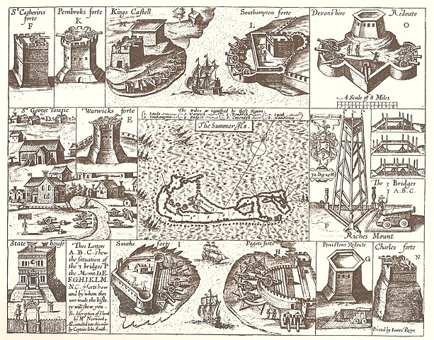
English: 1624 Map of Bermuda, with illustrations of fortifications and importand sites, including St. George's, Bermuda (the town), the State House, Bermuda, and the Castle Islands Fortifications, Bermuda |
| 日期 | |
| 来源 | The Generall Historie of Virginia, New-England, and the Summer Isles, by Captain John Smith of Jamestown, printed by I.D and I. H. for Michael Sparkes, 1624. Other editions 1625, 1626, 1627, 1631, and 1632. |
| 作者 | Printed by James Reeve |
许可协议
[编辑]
|
本作品在其来源国以及其他著作权期限是作者逝世后100年或以下的国家和地区属于公有领域。 | |
| 本文件已被确认为免除已知的著作权法限制(包括所有相关权利)。 | |
| 註解 | 該圖片含有註解:在維基媒體共享資源上查看註解 |
文件历史
点击某个日期/时间查看对应时刻的文件。
| 日期/时间 | 缩略图 | 大小 | 用户 | 备注 | |
|---|---|---|---|---|---|
| 当前 | 2008年2月10日 (日) 17:39 | | 1,370 × 1,073(1.39 MB) | Aodhdubh(留言 | 贡献) | {{Information |Description=1624 Map of Bermuda, with illustrations of fortifications and importand sites, including St. George's Town, the State House, and the [[Castle Islands Fortifications, Bermuda |
您不可以覆盖此文件。
文件用途
全域文件用途
以下其他wiki使用此文件:
- ar.wikipedia.org上的用途
- en.wikipedia.org上的用途
- Church of England
- Militia
- History of Bermuda
- Military of Bermuda
- John Smith (explorer)
- Fortification
- Robert Rich, 2nd Earl of Warwick
- Sea Venture
- Coastal artillery
- William Sayle
- County surveyor
- Bermuda Militia (1612–1815)
- Bermuda Militia (1612–1687)
- List of World Heritage Sites in the United Kingdom
- Architecture of Bermuda
- Castle Islands Fortifications, Bermuda
- State House, Bermuda
- Militia (England)
- English overseas possessions in the Wars of the Three Kingdoms
- St. Peter's Church, St. George's
- Coastal defence and fortification
- Bermuda Garrison
- User:DadrianT,Esq/County Surveyor draft page
- Fort St. Catherine
- Historic Town of St George and Related Fortifications, Bermuda
- Militia (British Empire)
- Fort George, Bermuda
- fi.wikipedia.org上的用途
- fr.wikipedia.org上的用途
- gl.wikipedia.org上的用途
- he.wikipedia.org上的用途
- hy.wikipedia.org上的用途
- id.wikipedia.org上的用途
- lv.wikipedia.org上的用途
- ms.wikipedia.org上的用途
- mt.wikipedia.org上的用途
- pl.wikipedia.org上的用途
- pt.wikipedia.org上的用途
- ru.wikipedia.org上的用途
- simple.wikipedia.org上的用途
- sl.wikipedia.org上的用途
- uk.wikipedia.org上的用途
- vi.wikipedia.org上的用途
- zh.wikipedia.org上的用途