File:Johnson & Browning Map of the United States and Mexico 1859 UTA.jpg
Original file (1,452 × 1,211 pixels, file size: 1.32 MB, MIME type: image/jpeg)
Captions
Captions
Summary
[edit]
| Title |
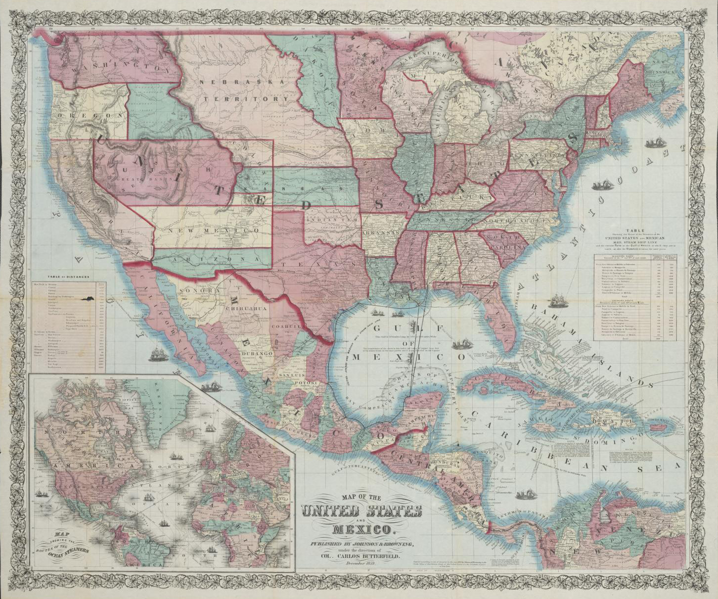
English: Map of the United States and Mexico |
||||||||||||||||||||||||||
| Description |
English: International overland mail routes, existing and proposed railroads, trails, and shipping routes throughout the United States, Mexico, Central America and the western Caribbean islands boldly appear on this map. Emphasizing the vast size of the United States and its important relationship to northern Latin America, shipping routes within and along the Gulf of Mexico served by the "United States and Mexican Mail Steamship Line" connect the southern U.S. ports of Mobile, New Orleans, and Galveston with the Yucatan and other parts of Mexico as well as Havana, Cuba. Proposed roads, trails, and railroads throughout the U.S. and particularly overland routes for mail, trade, and emigrants through south, west, and north Texas continue to destinations in Mexico, New Mexico, Arizona, and California. Reflecting the rapidly shifting forces at work in American politics of the time, the map records a number of odd boundaries for the new western territories in addition to the post-Gadsden Purchase boundary with Mexico.
This is the first edition of a map compiled by the New York mapmaking and publishing firm of Johnson & Browning under the direction of General Carlos Butterfield (d.1880), a U.S. and Mexican citizen with a colorful career. Born in upstate New York, he served with the Spanish Army Engineer Corps in Cuba in the early 1840s constructing railroads. After rising to the rank of captain, he went to Mexico in the mid-1840s and was commissioned a colonel, serving as an aide to General Antonio Lopez de Santa Anna and as engineer in chief and constructor general of the Mexican Navy. When released from service during the U.S. War with Mexico, U.S. occupation authorities appointed him alcalde of Veracruz. After the war he resumed his Mexican military career and served in several diplomatic and financial capacities as adviser and courier for U.S. officials in Mexico. Butterfield also became a partner associated with an import-export firm. He acquired Mexican citizenship in 1854 and supported the Ayutla rebellion against Santa Anna by supplying arms. Butterfield apparently traveled frequently and was in and out of Washington, D.C., and New York. He became involved with the Confederacy and gave financial support to ex-southern President Jefferson Davis' legal defense in 1865. He authored several books on United States-Latin American relations and died of pneumonia in Washington, D.C. on February 14, 1880. Oddly, no evidence as yet has been found of a connection between him and John W. Butterfield (1801-1869), founder of the Butterfield Stage Lines and American Express, who was also from upstate New York. |
||||||||||||||||||||||||||
| Date | |||||||||||||||||||||||||||
| Source | UTA Libraries Cartographic Connections: map / text | ||||||||||||||||||||||||||
| Creator |
Johnson & Browning |
||||||||||||||||||||||||||
| Credit line |
English: UTA Libraries Special Collections |
||||||||||||||||||||||||||
| Geotemporal data | |||||||||||||||||||||||||||
| Map location |
United States of America Mexico |
||||||||||||||||||||||||||
| Georeferencing | If inappropriate please set warp_status = skip to hide. | ||||||||||||||||||||||||||
| Bibliographic data | |||||||||||||||||||||||||||
| Place of publication | New York City | ||||||||||||||||||||||||||
| Printed by |
Johnson & Browning (Carlos Butterfield) |
||||||||||||||||||||||||||
| Archival data | |||||||||||||||||||||||||||
| Collection |
|
||||||||||||||||||||||||||
| Dimensions | height: 81 cm (31.8 in); width: 97 cm (38.1 in) | ||||||||||||||||||||||||||
| Medium | lithograph on paper | ||||||||||||||||||||||||||
| artwork-references |
Shavit, David (1992) The United States in Latin America: A Historical Dictionary, New York City: Greenwood Press, pp. 50−51 Auction 23, no. 64. Dorothy Sloan Books. Retrieved on August 10, 2018. |
||||||||||||||||||||||||||
Licensing
[edit]

|
This file was provided to Wikimedia Commons by the University of Texas at Arlington Libraries as part of a cooperation project. The University of Texas at Arlington Libraries is part of the University of Texas at Arlington, a public research university located in Arlington, Texas.
|
This work was published before January 1, 1929 and it is anonymous or pseudonymous due to unknown authorship. It is in the public domain in the United States as well as countries and areas where the copyright terms of anonymous or pseudonymous works are 95 years or fewer since publication.
|
File history
Click on a date/time to view the file as it appeared at that time.
| Date/Time | Thumbnail | Dimensions | User | Comment | |
|---|---|---|---|---|---|
| current | 20:48, 17 March 2022 | | 1,452 × 1,211 (1.32 MB) | Michael Barera (talk | contribs) | == {{int:filedesc}} == {{Map |title = {{en|'''''Map of the United States and Mexico'''''}} |description = {{en|International overland mail routes, existing and proposed railroads, trails, and shipping routes throughout the United States, Mexico, Central America and the western Caribbean islands boldly appear on this map. Emphasizing the vast size of the United States and its important relationship to northern Latin America, shipping routes within and along the Gulf of Mexi... |
You cannot overwrite this file.
File usage on Commons
The following page uses this file: