File:Joso Flood, CKT20159-C3-57.jpg
Jump to navigation
Jump to search

Size of this preview: 800 × 522 pixels. Other resolutions: 320 × 209 pixels | 640 × 418 pixels | 1,024 × 668 pixels | 1,280 × 836 pixels | 2,560 × 1,671 pixels | 4,810 × 3,140 pixels.
Original file (4,810 × 3,140 pixels, file size: 1.42 MB, MIME type: image/jpeg)
Captions
Captions
Add a one-line explanation of what this file represents
Summary
[edit]| Description |
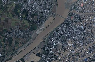
日本語: 平成27年9月関東・東北豪雨に伴う茨城県常総市水海道中心市街地の浸水被害の様子。
English: This photo shows flood disaster in central Mitsukaido region (Joso, Ibaraki Japan) by heavy rain at Kanto and Tohoku, 2015. |
| Date | |
| Source |
日本語: 国土画像情報(カラー空中写真)(整理番号:CKT20159、コース番号:C3、写真番号:57、撮影年月日:2015年9月11日、撮影地域:常総(9月11日午後)、撮影高度:2093m、撮影縮尺:1/7500、カメラ名称:UCX、焦点距離:100.500mm、カラー種別:カラー、写真種別:デジタル、撮影計画機関:国土地理院、市区町村名:常総市)http://mapps.gsi.go.jp/contentsImageDisplay.do?specificationId=1647551&isDetail=false
English: National Land Image Information (Color Aerial Photographs) (Reference number: CKT20159; Course Number: C3; Photo Number: 57; Date: September 11, 2015; Area: Joso (Sep. 11 Afternoon); Height: 2093 metre; Scale: 1/7500; Camera Name: UCX; Focal Distance: 100.500 millimetre; Color Type: Color; Photo Type: Degital; Agency: Geographical Survey Institute of Japan; Municipality: Joso City) http://mapps.gsi.go.jp/contentsImageDisplay.do?specificationId=1647551&isDetail=false |
| Author |
English: Geographical Survey Institute of Japan 日本語: 国土地理院 |
Licensing
[edit]
|
The copyright holder of this file, Ministry of Land, Infrastructure, Transport and Tourism, allows anyone to use it for any purpose, provided that the copyright holder is properly attributed. Redistribution, derivative work, commercial use, and all other use is permitted. |
Attribution:
National Land Image Information (Color Aerial Photographs), created by Ministry of Land, Infrastructure, Transport and Tourism, distributed by Geospatial Information Authority of Japan
|

File history
Click on a date/time to view the file as it appeared at that time.
| Date/Time | Thumbnail | Dimensions | User | Comment | |
|---|---|---|---|---|---|
| current | 10:33, 31 August 2016 | | 4,810 × 3,140 (1.42 MB) | Miyuki Meinaka (talk | contribs) | User created page with UploadWizard |
You cannot overwrite this file.
File usage on Commons
The following page uses this file:
File usage on other wikis
The following other wikis use this file:
- Usage on ja.wikipedia.org