File:Journal.pone.0024024.g001-1.jpg
Jump to navigation
Jump to search

Size of this preview: 800 × 352 pixels. Other resolutions: 320 × 141 pixels | 640 × 282 pixels | 1,024 × 451 pixels | 1,280 × 564 pixels | 2,377 × 1,047 pixels.
Original file (2,377 × 1,047 pixels, file size: 326 KB, MIME type: image/jpeg)
Captions
Captions
Add a one-line explanation of what this file represents
Summary
[edit]| Description |
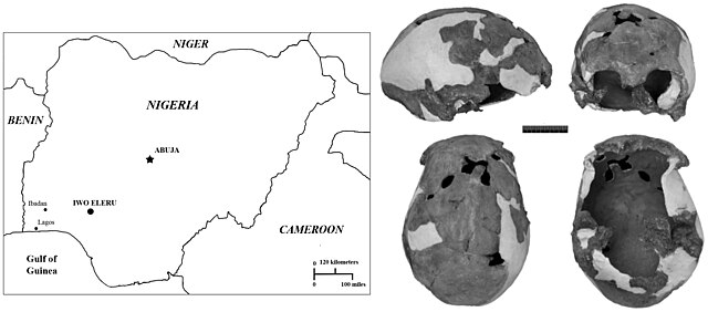
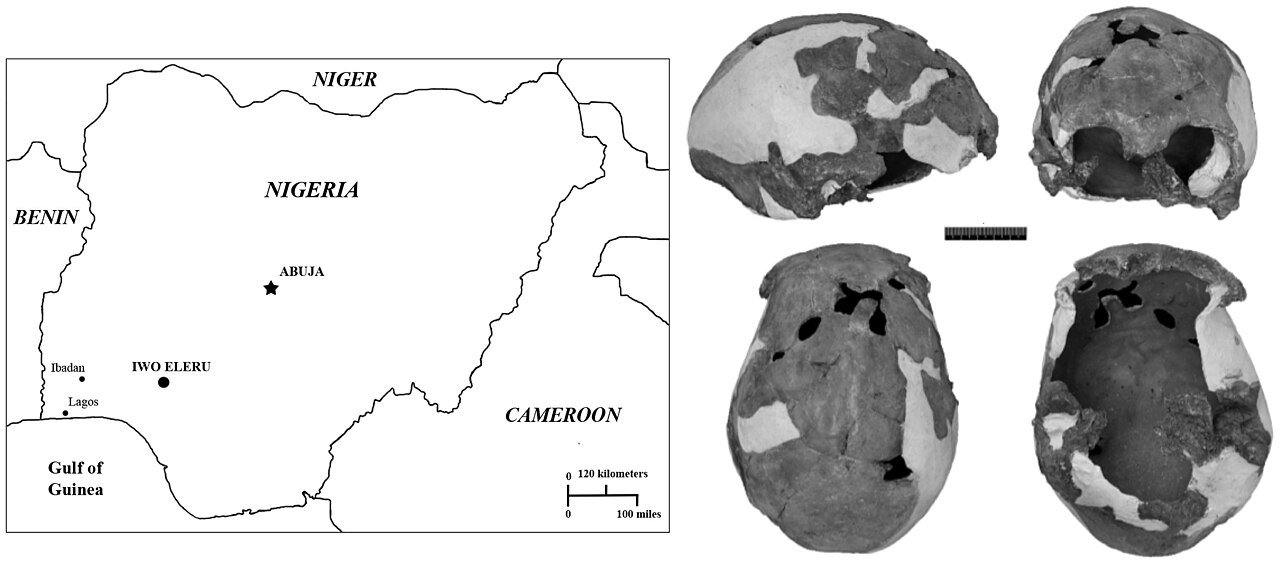
English: Map of Nigeria, showing the geographic location of the Iwo Eleru rockshelter, and the Iwo Eleru calvaria.
Clockwise from top left: Lateral, frontal, ventral and superior views. |
| Date | |
| Source | Figure 1 in: Harvati K, Stringer C, Grün R, Aubert M, Allsworth-Jones P, et al. (2011) The Later Stone Age Calvaria from Iwo Eleru, Nigeria: Morphology and Chronology. PLoS ONE 6(9): e24024 http://journals.plos.org/plosone/article?id=10.1371/journal.pone.0024024 |
| Author | Harvati K, Stringer C, Grün R, Aubert M, Allsworth-Jones P, et al. |
| Other versions |
.jpg)
.jpg)
From PLOS ONE, an open-access article distributed under the terms of the Creative Commons Attribution License, which permits unrestricted use, distribution, and reproduction in any medium, provided the original author and source are credited.
Licensing
[edit]
This file is licensed under the Creative Commons Attribution 4.0 International license.
- You are free:
- to share – to copy, distribute and transmit the work
- to remix – to adapt the work
- Under the following conditions:
- attribution – You must give appropriate credit, provide a link to the license, and indicate if changes were made. You may do so in any reasonable manner, but not in any way that suggests the licensor endorses you or your use.
File history
Click on a date/time to view the file as it appeared at that time.
| Date/Time | Thumbnail | Dimensions | User | Comment | |
|---|---|---|---|---|---|
| current | 17:23, 16 March 2015 | | 2,377 × 1,047 (326 KB) | Gerbil (talk | contribs) | {{Information |Description ={{en|1=Map of Nigeria, showing the geographic location of the Iwo Eleru rockshelter, and the Iwo Eleru calvaria. Clockwise from top left: Lateral, frontal, ventral and superior views.}} |Source =Figure 1 in: Harv... |
You cannot overwrite this file.
File usage on Commons
The following 2 pages use this file:
File usage on other wikis
The following other wikis use this file:
- Usage on de.wikipedia.org
- Usage on en.wikipedia.org
- Usage on fr.wikipedia.org
- Usage on ha.wikipedia.org
- Usage on ru.wikipedia.org