File:Juan de fuca plate.png
Zur Navigation springen
Zur Suche springen
Größe dieser Vorschau: 493 × 600 Pixel. Weitere Auflösungen: 197 × 240 Pixel | 536 × 652 Pixel.
Originaldatei (536 × 652 Pixel, Dateigröße: 46 KB, MIME-Typ: image/png)
Bildtexte
Kurzbeschreibungen
Ergänze eine einzeilige Erklärung, was diese Datei darstellt.
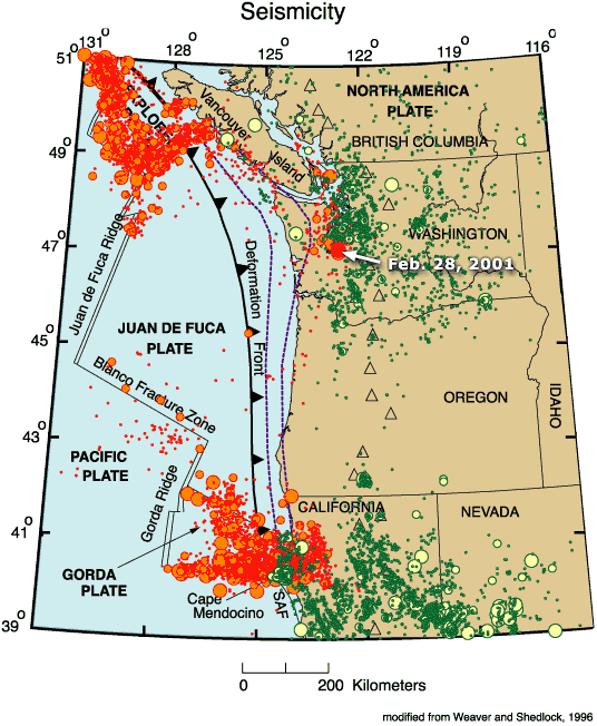
Map of the Juan de Fuca Plate
Beschreibung[Bearbeiten]
| Beschreibung |
English: Map of the Juan de Fuca Plate. |
| Datum | |
| Quelle | http://geomaps.wr.usgs.gov/pacnw/pacnweq/index.html |
| Urheber | The Pacific Northwest Urban Corridor Geologic Mapping Project of the Western Earth Surface Processes Team, Geologic Division, U.S. Geological Survey |
| Andere Versionen | :Image:Juan de fuca plate.jpeg |
Lizenz[Bearbeiten]
Dieses Bild ist gemeinfrei (public domain), weil es Materialien beeinhaltet, die ursprünglich vom United States Geological Survey, einer Behörde des Innenministeriums der Vereinigten Staaten, stammen. Weitere Informationen finden Sie in den Urheberrechtsbestimmungen des USGS
|
Ursprüngliches Datei-Logbuch[Bearbeiten]
Die ursprüngliche Dateibeschreibungsseite war hier. Alle folgenden Benutzernamen beziehen sich auf en.wikipedia.
- 2009-02-21 15:05 Wangi 536×652× (46902 bytes) {{Information |Description=Map of the [[Juan de Fuca Plate]]. |Source=http://geomaps.wr.usgs.gov/pacnw/pacnweq/index.html |Date=Feb 6, 2002 |Author= |Permission={{PD-USGov-Interior-USGS}} |other_versions=[[:Image:Juan de fuca plate.jpeg]] }}
Dateiversionen
Klicke auf einen Zeitpunkt, um diese Version zu laden.
| Version vom | Vorschaubild | Maße | Benutzer | Kommentar | |
|---|---|---|---|---|---|
| aktuell | 08:24, 11. Jan. 2010 | | 536 × 652 (46 KB) | Woudloper (Diskussion | Beiträge) | {{Information |Description={{en|Map of the en:Juan de Fuca Plate.}} |Source=Transferred from [http://en.wikipedia.org en.wikipedia]<br/> (Original text : ''http://geomaps.wr.usgs.gov/pacnw/pacnweq/index.html'') |Date=Feb 6, 2002<br/> ({{Date|2009|02 |
Du kannst diese Datei nicht überschreiben.
Dateiverwendung
Keine Seiten verwenden diese Datei.
Globale Dateiverwendung
Die nachfolgenden anderen Wikis verwenden diese Datei:
- Verwendung auf ar.wikipedia.org
- Verwendung auf de.wikipedia.org
- Verwendung auf en.wikipedia.org
- Verwendung auf fr.wikipedia.org
- Verwendung auf he.wikipedia.org
- Verwendung auf hi.wikipedia.org
- Verwendung auf ja.wikipedia.org
- Verwendung auf nl.wikipedia.org
- Verwendung auf oc.wikipedia.org
- Verwendung auf pl.wikipedia.org
- Verwendung auf ru.wikipedia.org
- Verwendung auf sh.wikipedia.org
- Verwendung auf sv.wikipedia.org
- Verwendung auf uk.wikipedia.org
- Verwendung auf zh.wikipedia.org
Kategorien:
- Tectonics maps
- Geological maps of the United States
- Geography of Oregon
- Geological maps of Canada
- Maps of the Pacific Ocean
- Subduction in North America
- Seismology in Canada
- Seismology in the United States
- Seismic maps
- Maps of subduction zones
- Earthquake maps of the Juan de Fuca tectonic plate
- Maps of the Gorda tectonic plate