File:Juan de fuca plate.png
跳转到导航
跳转到搜索
本预览的尺寸:493 × 600像素。 其他分辨率:197 × 240像素 | 536 × 652像素。
原始文件 (536 × 652像素,文件大小:46 KB,MIME类型:image/png)
说明
说明
添加一行文字以描述该文件所表现的内容
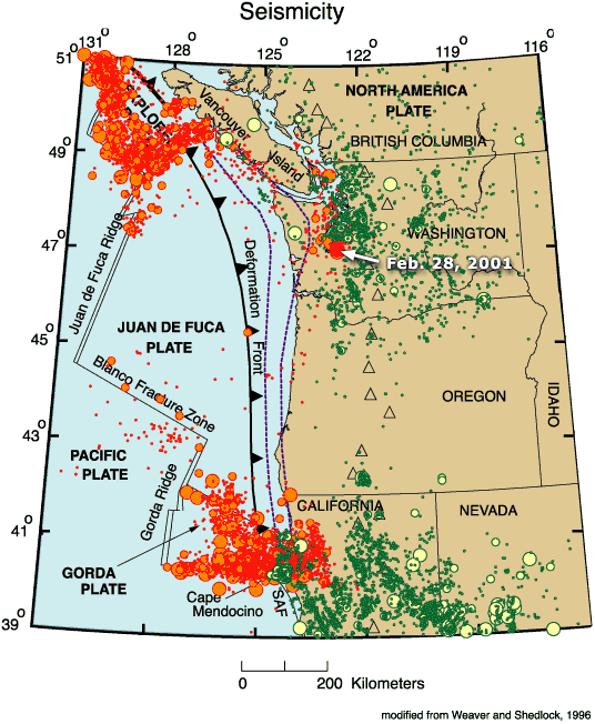
Map of the Juan de Fuca Plate
摘要
[编辑]
| 描述 |
English: Map of the Juan de Fuca Plate. |
| 日期 | |
| 来源 | http://geomaps.wr.usgs.gov/pacnw/pacnweq/index.html |
| 作者 | The Pacific Northwest Urban Corridor Geologic Mapping Project of the Western Earth Surface Processes Team, Geologic Division, U.S. Geological Survey |
| 其他版本 | :Image:Juan de fuca plate.jpeg |
许可协议
[编辑]
|
|
原始上传日志
[编辑]
The original description page was here. All following user names refer to en.wikipedia.
- 2009-02-21 15:05 Wangi 536×652× (46902 bytes) {{Information |Description=Map of the [[Juan de Fuca Plate]]. |Source=http://geomaps.wr.usgs.gov/pacnw/pacnweq/index.html |Date=Feb 6, 2002 |Author= |Permission={{PD-USGov-Interior-USGS}} |other_versions=[[:Image:Juan de fuca plate.jpeg]] }}
文件历史
点击某个日期/时间查看对应时刻的文件。
| 日期/时间 | 缩略图 | 大小 | 用户 | 备注 | |
|---|---|---|---|---|---|
| 当前 | 2010年1月11日 (一) 08:24 | | 536 × 652(46 KB) | Woudloper(留言 | 贡献) | {{Information |Description={{en|Map of the en:Juan de Fuca Plate.}} |Source=Transferred from [http://en.wikipedia.org en.wikipedia]<br/> (Original text : ''http://geomaps.wr.usgs.gov/pacnw/pacnweq/index.html'') |Date=Feb 6, 2002<br/> ({{Date|2009|02 |
您不可以覆盖此文件。
文件用途
没有页面使用本文件。
全域文件用途
以下其他wiki使用此文件:
- ar.wikipedia.org上的用途
- de.wikipedia.org上的用途
- en.wikipedia.org上的用途
- fr.wikipedia.org上的用途
- he.wikipedia.org上的用途
- hi.wikipedia.org上的用途
- ja.wikipedia.org上的用途
- nl.wikipedia.org上的用途
- oc.wikipedia.org上的用途
- pl.wikipedia.org上的用途
- ru.wikipedia.org上的用途
- sh.wikipedia.org上的用途
- sv.wikipedia.org上的用途
- uk.wikipedia.org上的用途
- zh.wikipedia.org上的用途
分类:
- Tectonics maps
- Geological maps of the United States
- Geography of Oregon
- Geological maps of Canada
- Maps of the Pacific Ocean
- Subduction in North America
- Seismology in Canada
- Seismology in the United States
- Seismic maps
- Maps of subduction zones
- Earthquake maps of the Juan de Fuca tectonic plate
- Maps of the Gorda tectonic plate