File:Jvuo1942 en.png
Zur Navigation springen
Zur Suche springen
Größe dieser Vorschau: 641 × 600 Pixel. Weitere Auflösungen: 256 × 240 Pixel | 513 × 480 Pixel | 821 × 768 Pixel | 1.076 × 1.007 Pixel.
Originaldatei (1.076 × 1.007 Pixel, Dateigröße: 132 KB, MIME-Typ: image/png)
Bildtexte
Kurzbeschreibungen
Ergänze eine einzeilige Erklärung, was diese Datei darstellt.
Beschreibung[Bearbeiten]
| Beschreibung |
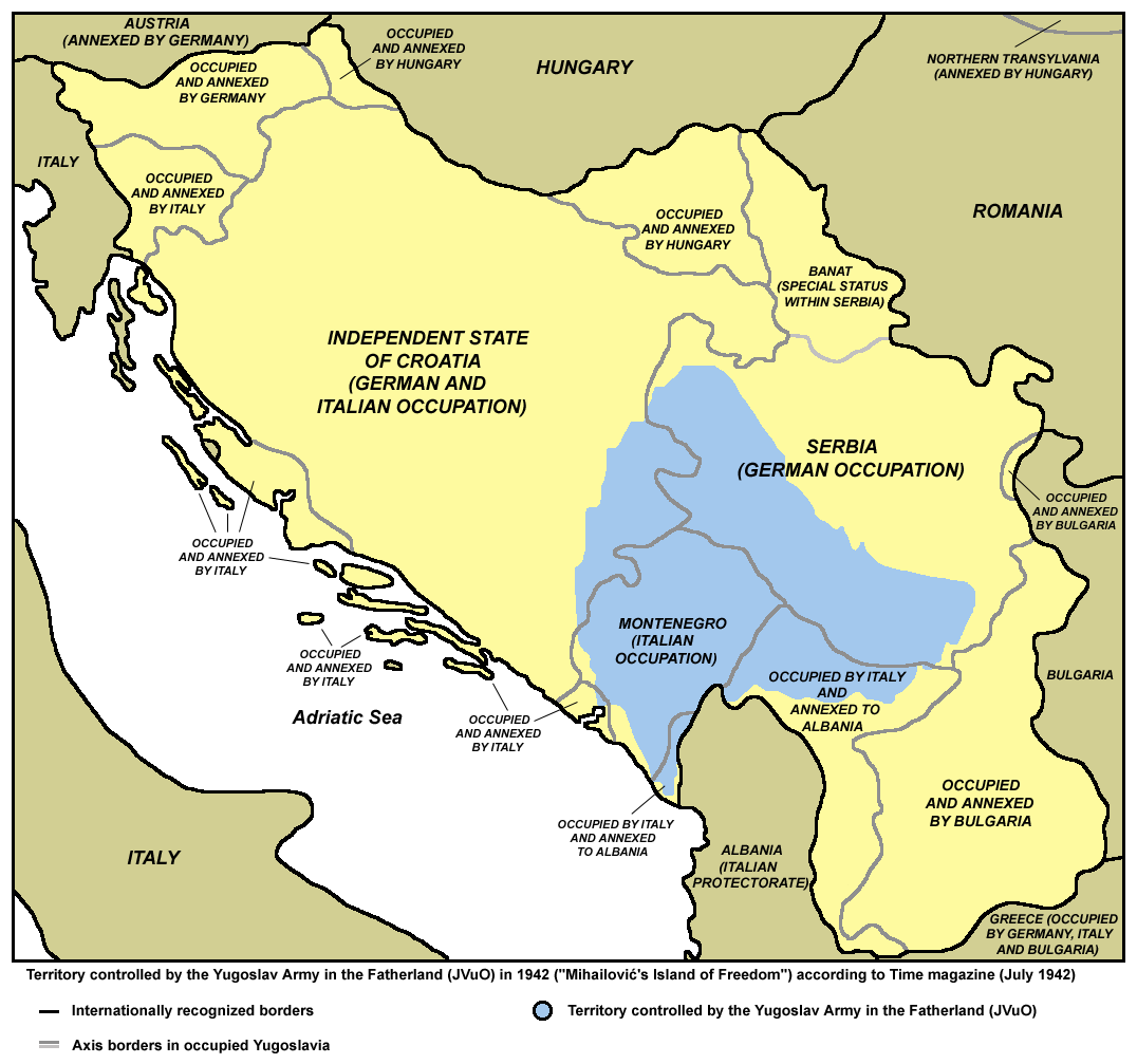
English: Territory controlled by the Yugoslav Army in the Fatherland (JVuO) in 1942 ("Mihailović's Island of Freedom") according to Time magazine (July 1942). Српски / srpski: Teritorija pod kontrolom Jugoslovenske vojske u otadžbini (JVuO) 1942. godine ("Mihailovićevo ostrvo slobode"), prema magazinu Tajm, juli 1942. |
| Datum | |
| Quelle | Eigenes Werk |
| Urheber | PANONIAN |
Lizenz[Bearbeiten]
Ich, der Urheber dieses Werkes, veröffentliche es unter der folgenden Lizenz:
| Diese Datei wird unter der Creative-Commons-Lizenz „CC0 1.0 Verzicht auf das Copyright“ zur Verfügung gestellt. | |
| Die Person, die das Werk mit diesem Dokument verbunden hat, übergibt dieses weltweit der Gemeinfreiheit, indem sie alle Urheberrechte und damit verbundenen weiteren Rechte – im Rahmen der jeweils geltenden gesetzlichen Bestimmungen – aufgibt. Das Werk kann – selbst für kommerzielle Zwecke – kopiert, modifiziert und weiterverteilt werden, ohne hierfür um Erlaubnis bitten zu müssen.
|
References[Bearbeiten]
- Mr Radovan Kalabić, Ravnogorska istorija, Beograd, 1992.
- http://upload.wikimedia.org/wikipedia/sh/7/77/Četničko_ostrvo_slobode.jpg
- http://t2.gstatic.com/images?q=tbn:ANd9GcR2b-_eiCCmU7sdzRFb3jQoOcETY87wu14NqYy3je2QRAoEJK088w
Dateiversionen
Klicke auf einen Zeitpunkt, um diese Version zu laden.
| Version vom | Vorschaubild | Maße | Benutzer | Kommentar | |
|---|---|---|---|---|---|
| aktuell | 11:10, 15. Mai 2013 | | 1.076 × 1.007 (132 KB) | PANONIAN (Diskussion | Beiträge) | {{Information |Description ={{en|1=Territory controlled by the Yugoslav Army in the Fatherland (JVuO) in 1942.}} |Source ={{own}} |Author =PANONIAN |Date =2013 |Permission = |other_versions = }} |
Du kannst diese Datei nicht überschreiben.
Dateiverwendung
Die folgenden 5 Seiten verwenden diese Datei:
Globale Dateiverwendung
Die nachfolgenden anderen Wikis verwenden diese Datei:
- Verwendung auf ca.wikipedia.org
- Verwendung auf cs.wikipedia.org
- Verwendung auf de.wikipedia.org
- Verwendung auf en.wikipedia.org
- Verwendung auf fi.wikipedia.org
- Verwendung auf fr.wikipedia.org
- Verwendung auf hr.wikipedia.org
- Verwendung auf it.wikipedia.org
- Verwendung auf ja.wikipedia.org
- Verwendung auf sh.wikipedia.org
- Verwendung auf sl.wikipedia.org
- Verwendung auf uk.wikipedia.org
Kategorien:
- Maps of Yugoslavia during World War II
- Maps of Serbia during World War II
- Maps of Montenegro during World War II
- Maps of the Independent State of Croatia
- Maps of the history of Bosnia and Herzegovina in modern times
- Maps of Bosnia and Herzegovina during World War II
- Maps of the history of Kosovo in modern times
- Chetniks during World War II