File:Jylland overview map2.PNG
Jump to navigation
Jump to search

Size of this preview: 332 × 600 pixels. Other resolutions: 133 × 240 pixels | 266 × 480 pixels | 964 × 1,741 pixels.
Original file (964 × 1,741 pixels, file size: 171 KB, MIME type: image/png)
Captions
Captions
Add a one-line explanation of what this file represents

|
This historical map image could be re-created using vector graphics as an SVG file. This has several advantages; see Commons:Media for cleanup for more information. If an SVG form of this image is available, please upload it and afterwards replace this template with
{{vector version available|new image name}}.
It is recommended to name the SVG file “Jylland overview map2.svg”—then the template Vector version available (or Vva) does not need the new image name parameter. |
Summary[edit]
| Description |
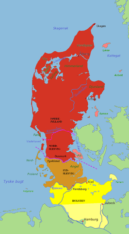
Jutland and the Jutland Peninsula Red: Commonly defined as Jutland today, including the area north of the Limfjord and minor islands Pink: The islands of Læsø, Anholt, Samsø and Als are usually attributed to Jutland as well Brown: South Slesvig/Schleswig in the German state of Schleswig-Holstein, historically a part of Jutland Yellow: Holstein, situated on the Jutland Peninsula, but not in Jutland itself. The river Kongeå is the historical border between Northern and Southern Jutland (Slesvig). The river Eider is the historical southern border of Jutland (and formerly Denmark), and between Slesvig and Holstein. The city of Rendsburg and the island of Helgoland are sometimes regarded as Slesvig, sometimes not. The Jutland Peninsula as a geographic term has no fixed southern border, but at its furthest it would stretch to the river Elbe. Hamburg, however, is not a part of Holstein, and Lübeck was not a part of Holstein until the 20th century. The Jutland Peninsula may also be called the Cimbrian Peninsula, Jutland-Holstein or Jutland-Schleswig-Holstein. |
| Date | |
| Source | self-made / edited from original map by Astrokey44 (GFDL). |
| Author | Casper |
Licensing[edit]
I, Casper, the copyright holder of this work, hereby publishes it under the following licenses:

|
Permission is granted to copy, distribute and/or modify this document under the terms of the GNU Free Documentation License, Version 1.2 or any later version published by the Free Software Foundation; with no Invariant Sections, no Front-Cover Texts, and no Back-Cover Texts. A copy of the license is included in the section entitled GNU Free Documentation License. |
| This file is licensed under the Creative Commons Attribution-Share Alike 3.0 Unported license. | ||
| Attribution: I, Casper | ||
| ||
| This licensing tag was added to this file as part of the GFDL licensing update. |
This file is licensed under the Creative Commons Attribution-Share Alike 2.5 Generic, 2.0 Generic and 1.0 Generic license.
Attribution: I, Casper
- You are free:
- to share – to copy, distribute and transmit the work
- to remix – to adapt the work
- Under the following conditions:
- attribution – You must give appropriate credit, provide a link to the license, and indicate if changes were made. You may do so in any reasonable manner, but not in any way that suggests the licensor endorses you or your use.
- share alike – If you remix, transform, or build upon the material, you must distribute your contributions under the same or compatible license as the original.
You may select the license of your choice.
File history
Click on a date/time to view the file as it appeared at that time.
| Date/Time | Thumbnail | Dimensions | User | Comment | |
|---|---|---|---|---|---|
| current | 03:03, 10 July 2007 | | 964 × 1,741 (171 KB) | Casper~commonswiki (talk | contribs) | == Summary == {{Information |Description='''Jutland and the Jutland Peninsula'''<br><br>'''Red:''' Commonly defined as Jutland today, including the area north of the Limfjord and minor islands<br>'''Pink:''' The islands of Læsø, Anholt, Samsø and Als a |
You cannot overwrite this file.
File usage on Commons
The following page uses this file:
File usage on other wikis
The following other wikis use this file:
- Usage on be.wikipedia.org
- Usage on ca.wikipedia.org
- Usage on ceb.wikipedia.org
- Usage on da.wikipedia.org
- Usage on en.wikipedia.org
- Usage on es.wikipedia.org
- Usage on fa.wikipedia.org
- Usage on fr.wikipedia.org
- Usage on it.wikipedia.org
- Usage on ko.wikipedia.org
- Usage on nn.wikipedia.org
- Usage on no.wikipedia.org
- Usage on pt.wikipedia.org
- Usage on ru.wikipedia.org
- Usage on sv.wikipedia.org
- Usage on vi.wikipedia.org
- Usage on wa.wikipedia.org
- Usage on www.wikidata.org