File:Kõrgesaare mõisa külade Kõpu ja Ojaküla-Ülendi plaanid 1880-1884.jpg
Jump to navigation
Jump to search

Size of this preview: 759 × 600 pixels. Other resolutions: 304 × 240 pixels | 607 × 480 pixels | 972 × 768 pixels | 1,280 × 1,012 pixels | 2,560 × 2,024 pixels | 4,000 × 3,162 pixels.
Original file (4,000 × 3,162 pixels, file size: 9.42 MB, MIME type: image/jpeg)
Captions
Captions
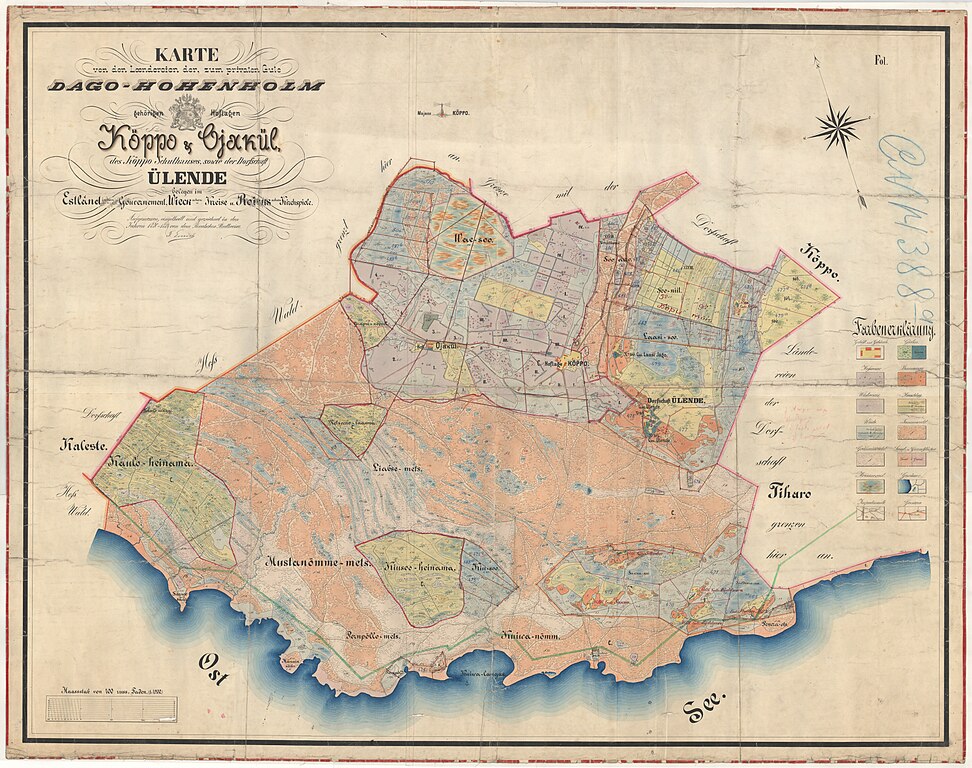
Map of Kõpu (Kõppo) and Ojaküla-Ülendi villages under Kõrgessaare manor. Land surveyor F. Eurich M 1:4200
Summary[edit]
| Description |
English: Map compiled in 1880–1884 depicting the buildings and land borders in the area of Kõpu and Ojaküla-Ülendi villages.
Eesti: 1880.–1884. aastal koostatud kaart, mis näitab maajaotust ja hooneid Kõpu ja Ojaküla-Ülendi külades |
| Date | 1880–1884 |
| Source | https://www.ra.ee/kaardid/index.php/et/map/view?id=4283 |
| Author | Friedrich Eurich |
| Camera location | | View this and other nearby images on: OpenStreetMap |
|---|
Licensing[edit]
|
This work is in the public domain in its country of origin and other countries and areas where the copyright term is the author's life plus 70 years or fewer. This work is in the public domain in the United States because it was published (or registered with the U.S. Copyright Office) before January 1, 1929. | |
| This file has been identified as being free of known restrictions under copyright law, including all related and neighboring rights. | |
File history
Click on a date/time to view the file as it appeared at that time.
| Date/Time | Thumbnail | Dimensions | User | Comment | |
|---|---|---|---|---|---|
| current | 08:53, 7 May 2023 | | 4,000 × 3,162 (9.42 MB) | Monrep (talk | contribs) | Uploaded a work by Friedrich Eurich from https://www.ra.ee/kaardid/index.php/et/map/view?id=4283&_xr=eNolizkOgDAQA%252F%252ByDwgEIkBOlYKHrJLlkCAgrgbxd67OHo8ZGmeP1DLyP6zQFWjkOVmFF9%252B5cHD0EuhZStAijZ%252BCvE0bUO2cysvMKKOK1Lz0OQ8c253bT8pAspG9rhukYh9l with UploadWizard |
You cannot overwrite this file.
File usage on Commons
There are no pages that use this file.
File usage on other wikis
The following other wikis use this file:
- Usage on et.wikipedia.org