File:Kölnische Straße Nr. 3, Strata Coloniensis Süd, Haus Bürgel - Mettmann (n. E. Krumme).jpg
Jump to navigation
Jump to search

Size of this preview: 800 × 450 pixels. Other resolutions: 320 × 180 pixels | 640 × 360 pixels | 1,280 × 720 pixels.
Original file (1,280 × 720 pixels, file size: 245 KB, MIME type: image/jpeg)
Captions
Captions
Add a one-line explanation of what this file represents
Summary[edit]
| Description |
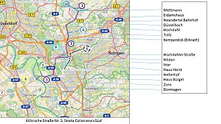
Deutsch: Kölnische Straße Nr. 3, Strata Coloniensis Süd, Haus Bürgel - Mettmann (nach E. Krumme)
Basic informations: Erich Krumme, Die Kölnischen Straßen im Niederbergischen Raum, Romerike Berge, Zeitschrift für Heimatpflege im Bergischen Land 11. Jg. 1961/62 Heft 2, S. 68-80; Background of maps: Openstreetmap |
||
| Date | |||
| Source | Own work | ||
| Author | Paulgerhard | ||
| Other versions |
|


.jpg&action=edit§ion=1)
Licensing[edit]
.jpg&action=edit§ion=2)
I, the copyright holder of this work, hereby publish it under the following license:
This file is licensed under the Creative Commons Attribution-Share Alike 4.0 International license.
- You are free:
- to share – to copy, distribute and transmit the work
- to remix – to adapt the work
- Under the following conditions:
- attribution – You must give appropriate credit, provide a link to the license, and indicate if changes were made. You may do so in any reasonable manner, but not in any way that suggests the licensor endorses you or your use.
- share alike – If you remix, transform, or build upon the material, you must distribute your contributions under the same or compatible license as the original.
File history
Click on a date/time to view the file as it appeared at that time.
| Date/Time | Thumbnail | Dimensions | User | Comment | |
|---|---|---|---|---|---|
| current | 14:32, 28 June 2017 | | 1,280 × 720 (245 KB) | Paulgerhard (talk | contribs) | Trasse 5: Weg durch Hilden Kalstert, anstelle über Elberfelder Straße |
| 06:38, 14 October 2014 |  | 1,280 × 720 (246 KB) | Paulgerhard (talk | contribs) | Hintergrund Openstreetmap anstelle von Google maps | |
| 04:45, 9 October 2014 |  | 1,280 × 720 (189 KB) | Paulgerhard (talk | contribs) | Straßennummerierung wurde hinzugefügt | |
| 17:54, 7 October 2014 |  | 1,280 × 720 (182 KB) | Paulgerhard (talk | contribs) | User created page with UploadWizard |
You cannot overwrite this file.
File usage on Commons
There are no pages that use this file.
File usage on other wikis
The following other wikis use this file:
- Usage on de.wikipedia.org
.jpg&oldid=494807483)