File:KMB73K RtMap.png
Jump to navigation
Jump to search

Size of this preview: 191 × 598 pixels. Other resolutions: 76 × 240 pixels | 477 × 1,494 pixels.
Original file (477 × 1,494 pixels, file size: 206 KB, MIME type: image/png)
Captions
Captions
Add a one-line explanation of what this file represents
Summary
[edit]
| Description |
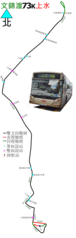
中文(香港):九巴73K線的走線圖 |
| Date | |
| Source | Own work |
| Author | ATR50 |
Licensing
[edit]
I, the copyright holder of this work, hereby publish it under the following license:
This file is licensed under the Creative Commons Attribution-Share Alike 3.0 Unported license.
- You are free:
- to share – to copy, distribute and transmit the work
- to remix – to adapt the work
- Under the following conditions:
- attribution – You must give appropriate credit, provide a link to the license, and indicate if changes were made. You may do so in any reasonable manner, but not in any way that suggests the licensor endorses you or your use.
- share alike – If you remix, transform, or build upon the material, you must distribute your contributions under the same or compatible license as the original.
File history
Click on a date/time to view the file as it appeared at that time.
| Date/Time | Thumbnail | Dimensions | User | Comment | |
|---|---|---|---|---|---|
| current | 02:17, 13 May 2018 | 477 × 1,494 (206 KB) | ATR50~commonswiki (talk | contribs) | 2018年春季增站(並且執靚過) | |
| 03:56, 4 January 2016 |  | 840 × 1,945 (397 KB) | ATR50~commonswiki (talk | contribs) | 2016年1月香港政府縮減邊境禁區範圍,本線完全撤出邊境禁區,所有民眾皆可搭乘本路線前往文錦渡路近羅湖道巴士站起至文錦渡總站 | |
| 16:55, 8 February 2014 |  | 920 × 1,945 (426 KB) | ATR50~commonswiki (talk | contribs) | 初九改良版 | |
| 16:27, 29 August 2013 |  | 920 × 1,945 (215 KB) | ATR50~commonswiki (talk | contribs) | User created page with UploadWizard |
You cannot overwrite this file.
File usage on Commons
The following 7 pages use this file:
- User:Chumwa/OgreBot/Potential transport maps/2018 May 11-20
- User:Chumwa/OgreBot/Public transport information/2016 January 1-10
- User:Chumwa/OgreBot/Public transport information/2018 May 11-20
- User:Chumwa/OgreBot/Transport Maps/2016 January 1-10
- User:Chumwa/OgreBot/Transport Maps/2018 May 11-20
- User:Chumwa/OgreBot/Travel and communication maps/2018 May 11-20
- User:OgreBot/Watercraft/2018 May 13
File usage on other wikis
The following other wikis use this file:
- Usage on zh.wikipedia.org