File:KZ Dachau und KZ-Friedhöfe - Lageplan Übersicht.png

Original file (3,555 × 2,963 pixels, file size: 6.91 MB, MIME type: image/png)
Captions
Captions
Summary[edit]
| Description |
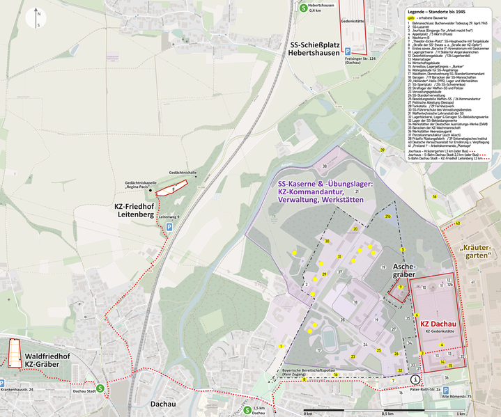
English: Map of Dachau concentration camp and cemeteries (german version), with buildings until 1945 - overview
Deutsch: KZ Dachau und KZ-Friedhöfe - Lageplan Übersicht, mit Gebäuden bis 1945
Base for 1-35: https://commons.wikimedia.org/wiki/File:Concentration_camp_dachau_aerial_view.jpg#Summary Labeled with same numbers 1-35, added numbers 36-41 Legende – Standorte bis 1945 gelb – erhaltene Bauwerke 1 Bahnanschluss: Buchenwalder Todeszug 29. April 1945 2 SS-Lazarett 3 Jourhaus (Eingangs-Tor „Arbeit macht frei“) 4 Appellplatz 5 Würm (Fluss) 6 Wachturm B 7 „Theodor-Eicke-Platz“: SS-Hauptwache mit Torgebäude 8 „Straße der SS“ (heute u. a. „Straße der KZ-Opfer“) 9 Erstes sowie „Baracke X“-Krematorium mit Gaskammer 10 Lagergärtnerei 11 Ställe für Angorakaninchen 12 Desinfektionsgebäude 12b Lagerbordell 13 Materiallager 14 Wirtschaftsgebäude 15 Arrestbau Lagergefängnis – „Bunker“ 16 Wohngebäude für SS-Angehörige 17 Waldheim, Dienstwohnung SS-Standortkommandant 18 Garagen 19 Baracken der SS-Mannschaften 20 „Holländer“-Halle (1915), Lager und Werkstätten 21 SS-Sportplatz 21b SS-Schwimmbad 22 Straflager der Waffen-SS und Polizei 23 Verwaltungsgebäude 24 SS-Standortverwaltung 25 Besoldungsstelle Waffen-SS 26 Kommandantur 27 Politische Abteilung (Gestapo) 28 Tankstelle 29 Fernheizwerk 30 SS-Führerschule des Verwaltungsdienstes 31 Waffentechnische Lehranstalt der SS 32 Lagerbäckerei, Lager & Garagen SS-Bekleidungswerke 33 Lager der SS-Bekleidungswerke 34 Werkstätten der Deutschen Ausrüstungs-Werke (DAW) 35 Baracken der KZ-Wachmannschaft 36 Werkstätten Heereszeugamt 37 Porzellanmanufaktur (auch Allach) 38 Präzifix Rüstungsfabrik 39 Entomologisches Institut 40 Deutsche Versuchsanstalt für Ernährung u. Verpflegung 41 „Freiland I“ - Arbeitskommando „Plantage“ Jourhaus – Kräutergarten 1,3 km (oder Bus) Jourhaus – S-Bahn Dachau Stadt 2,3 km (oder Bus) S-Bahn Dachau Stadt – KZ-Friedhof Leitenberg 1,3 km Other labels: SS-Kommandantur des KZ, SS-Übungslager, SS-Wohn- & Verwaltungsbereich, Werkstätten KZ Dachau Aschegräber SS-Schießplatz Hebertshausen „Kräutergarten“ KZ-Friedhof Leitenberg Waldfriedhof KZ-Gräber Gedächtniskapelle „Regina Pacis“ KZ-Gedenkstätte Bayerische Bereitschaftspolizei (Kein Zugang) |
| Date | |
| Source | https://www.openstreetmap.org/#map=16/48.2727/11.4547 |
| Author |
© OpenStreetMap-Mitwirkende, openstreetmap.org, CC BY-SA 2.0. Ergänzt mit Angaben zum ehemaligen KZ Dachau |
| Other versions |
|


Licensing[edit]
- You are free:
- to share – to copy, distribute and transmit the work
- to remix – to adapt the work
- Under the following conditions:
- attribution – You must give appropriate credit, provide a link to the license, and indicate if changes were made. You may do so in any reasonable manner, but not in any way that suggests the licensor endorses you or your use.
- share alike – If you remix, transform, or build upon the material, you must distribute your contributions under the same or compatible license as the original.
File history
Click on a date/time to view the file as it appeared at that time.
| Date/Time | Thumbnail | Dimensions | User | Comment | |
|---|---|---|---|---|---|
| current | 17:08, 4 September 2022 | | 3,555 × 2,963 (6.91 MB) | Treck08 (talk | contribs) | Small optimizations |
| 14:33, 3 September 2022 |  | 3,555 × 2,963 (6.91 MB) | Treck08 (talk | contribs) | Small optimizations and fixes | |
| 16:08, 2 September 2022 |  | 3,555 × 2,963 (6.9 MB) | Treck08 (talk | contribs) | much besser quality, lighter, same numbers and informatiion | |
| 14:28, 1 September 2022 |  | 3,000 × 1,689 (4.89 MB) | Treck08 (talk | contribs) | Uploaded a work by © OpenStreetMap-Mitwirkende, openstreetmap.org, CC BY-SA 2.0. Ergänzt mit Angaben zum ehemaligen KZ Dachau from https://www.openstreetmap.org/#map=16/48.2727/11.4547 with UploadWizard |
You cannot overwrite this file.
File usage on Commons
The following 6 pages use this file:
- User:Magog the Ogre/Maps of conflicts/2022 September
- File:Concentration camp dachau aerial view.jpg
- File:Dachau Gedenkstätte Aerial.jpg
- File:KZ Dachau und KZ-Friedhöfe - Lageplan Übersicht.png
- File:Map of Dachau concentration camp and cemeteries overview - english.png
- File:Map of Dachau concentration camp and cemeteries overview - without labels.png
File usage on other wikis
The following other wikis use this file:
- Usage on de.wikipedia.org
- Usage on it.wikipedia.org