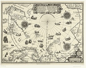
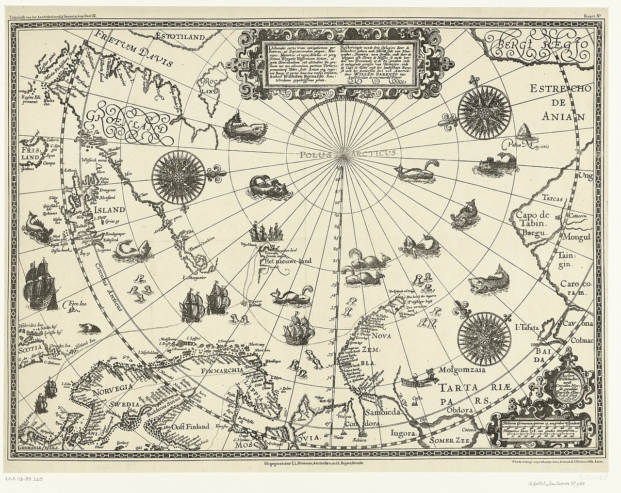
File:Kaart van de landen rond de poolcirkel met de drie reizen van de Nederlanders, 1598 Beschrijvinghe van de drie seylagien door de Hollanders gedaen ande Noordt syde van Noorweghen, Moscovia, nova Sembla, ende door het de, RP-P-OB-80.320.jpg
Перейти к навигации
Перейти к поиску

Размер этого предпросмотра: 755 × 600 пкс. Другие разрешения: 302 × 240 пкс | 604 × 480 пкс | 967 × 768 пкс | 1280 × 1017 пкс | 2560 × 2034 пкс | 6250 × 4966 пкс.
Исходный файл (6250 × 4966 пкс, размер файла: 6,26 МБ, MIME-тип: image/jpeg)
Краткие подписи
Краткие подписи
Добавьте однострочное описание того, что собой представляет этот файл
Краткое описание
[править]| Описание |
Nederlands: Identificatie Titel(s): Kaart van de landen rond de poolcirkel met de drie reizen van de Nederlanders, 1598. Beschrijvinghe van de drie seylagien door de Hollanders gedaen ande Noordt syde van Noorweghen, Moscovia, nova Sembla, ende door het deel van Groenlandt op de 80. graeden ende de omleggende grensen van Tartaryen ende de Capo de Tabin ende des landtschaps Bargi, so oock het Oostersche deel van America: door Willem Barents van Amstelredam de vermaerde Piloot (titel op object) Objecttype: prent nieuwsprent kaart Objectnummer: RP-P-OB-80.320 Catalogusreferentie: FMH 1055-B, New Hollstein Dutch 983 Opmerking: facsimile Omschrijving: Kaart van Noord-Europa en de landen rond de poolcirkel waarop aangegeven de drie reizen van de Nederlanders eind zestiende eeuw. Met de oostkust van Canada, Groenland, IJsland, het noorden van Scandinavië, noordkust van Rusland en Nova Zembla. Bovenin een cartouche met de titel in het Latijn en Nederlands, rechtsonder de schalen. In de zee schepen, walvissen en zeehonden. Facsimile van de originele kaart uit 1598. Vervaardiging Vervaardiger: prentmaker: Arnaud A.J. Pistoor (vermeld op object), naar prent van: Baptista van Doetechum, cartograaf: Willem Barendsz, uitgever: C.L. Brinkman (vermeld op object), uitgever: J.L. Beijers (vermeld op object) Plaats vervaardiging: prentmaker: Nederland, uitgever: Amsterdam, uitgever: Utrecht Datering: 1878 Fysieke kenmerken: fotolithografische reproductie Materiaal: papier Techniek: fotolithografie Afmetingen: blad: h 435 mm × b 565 mm Toelichting Facsimile van de originele kaart uit 1598, vervaardigd voor het Tijdschrift van het Aardrijkskundig Genootschap, Deel III (1878). Onderwerp Wat: exploration, expedition, voyage of discoverymaps of the continents and the polar regions Wanneer: 1598 Waar: IJsland, Groenland, Canada, Nova Zembla, Scandinavië, Rusland, Noordpool, Poolcirkel, Lapland Wie: Willem Barendsz Verwerving en rechten Verwerving: aankoop 1881 Copyright: Publiek domein |
| Дата | 1878, from a 1598 original |
| Источник | http://hdl.handle.net/10934/RM0001.COLLECT.450909 |
| Автор | Arnaud A.J. Pistoor, photolithography from Baptista van Doetecum's engraving of Cornelis Claesz's drawing of Willem Barentsz's charts. |
| Другие версии |
|

.jpg)
_door_Willem_Barendsz_(titel_op_object),_NG-800.jpg)


Лицензирование
[править]
| Этот файл доступен на условиях Creative Commons CC0 1.0 Универсальной передачи в общественное достояние (Universal Public Domain Dedication). | |
| Лица, связанные с работой над этим произведением, решили передать данное произведение в общественное достояние, отказавшись от всех прав на произведение по всему миру в рамках закона об авторских правах (а также связанных и смежных прав), в той степени, которую допускает закон. Вы можете копировать, изменять, распространять, исполнять данное произведение в любых целях, в том числе в коммерческих, без получения на это разрешения автора.
|
| Аннотации | Это изображение аннотировано: Просмотреть аннотации на Викискладе |
История файла
Нажмите на дату/время, чтобы увидеть версию файла от того времени.
| Дата/время | Миниатюра | Размеры | Участник | Примечание | |
|---|---|---|---|---|---|
| текущий | 01:35, 1 января 2020 | | 6250 × 4966 (6,26 МБ) | Mr.Nostalgic (обсуждение | вклад) | == {{int:filedesc}} == {{Information |Description={{nl|1=<br><br><big>'''Identificatie'''</big><br>'''Titel(s): '''Kaart van de landen rond de poolcirkel met de drie reizen van de Nederlanders, 1598Beschrijvinghe van de drie seylagien door de Hollanders gedaen ande Noordt syde van Noorweghen, Moscovia, nova Sembla, ende door het deel van Groenlandt op de 80. graeden ende de omleggende grensen van Tartaryen ende de Capo de Tabin ende des landtschaps Bargi, so oock het Oostersche deel van Ameri... |
Вы не можете перезаписать этот файл.
Использование файла
Следующие 7 страниц используют этот файл:
- File:1598 map of the Polar Regions by Willem Barentsz.jpg
- File:Barents third voyage.jpg
- File:Barentskartet, 1598 (12068020364).jpg
- File:Barentsz Full Map.jpg
- File:Forminsket utgave av Barentskartet - no-nb krt 00487.jpg
- File:Kaart van het Noordpoolgebied, 1598 Beschrijvinghe van de drie seylagien door de Hollanders gedaan (..) door Willem Barendsz (titel op object), NG-800.jpg
- File:Pontanus 1611 Arctic Map.jpg
Категории:
- Overwintering on Nova Zembla by Willem Barentsz, 1596-1597
- Maps in the Rijksmuseum Amsterdam
- Prints of cartouches in the Rijksmuseum Amsterdam
- History prints in the Rijksmuseum Amsterdam
- 1878 maps
- 1590s maps of Sweden
- Arnaud Pistoor & Zn
- Third voyage of Willem Barentsz
- 16th-century maps of the Arctic
- History of Dutch sea fisheries
- 1598 maps of Russia
- Old maps of Spitsbergen
- Old maps of Scandinavia
- Maps of Novaya Zemlya
- Old maps of the Arctic
- Old maps of the White Sea
- Maps of the Barents Sea
- Maps of the Greenland Sea
- Old maps of the Arctic Ocean
- Old maps of Svalbard
- 1590s maps of Norway
- 1590s maps of Denmark
- 1590s maps of Iceland
- 1590s maps of Greenland
- 1590s maps of Scotland
- Magnetic pole
- Strait of Anian
- Davis Strait
- Maps of Frobisher Bay
- Terra incognita
- Phantom islands
- Dutch-language maps
- Animals on maps
- Whales on maps
- Monsters on maps
- Seals in art
- Maps of the Kara Sea
- Maps of the Beaufort Sea
- Maps of Baffin Bay
- Maps of the East Siberian Sea
- Maps of the Laptev Sea
- Maps of the Chukchi Sea
- 1590s maps of Finland
- Cornelis Claesz
- Baptista van Doetecum
- Maps of the North Pole
- Reindeer sleds in art
- Northern Sea Route