File:Kaart van het Noordpoolgebied, 1598 Beschrijvinghe van de drie seylagien door de Hollanders gedaan (..) door Willem Barendsz (titel op object), NG-800.jpg
Перейти к навигации
Перейти к поиску

Размер этого предпросмотра: 789 × 600 пкс. Другие разрешения: 316 × 240 пкс | 632 × 480 пкс | 1011 × 768 пкс | 1280 × 973 пкс | 2560 × 1946 пкс | 6028 × 4582 пкс.
Исходный файл (6028 × 4582 пкс, размер файла: 4,04 МБ, MIME-тип: image/jpeg)
Краткие подписи
Краткие подписи
Добавьте однострочное описание того, что собой представляет этот файл
Краткое описание
[править]| Описание |
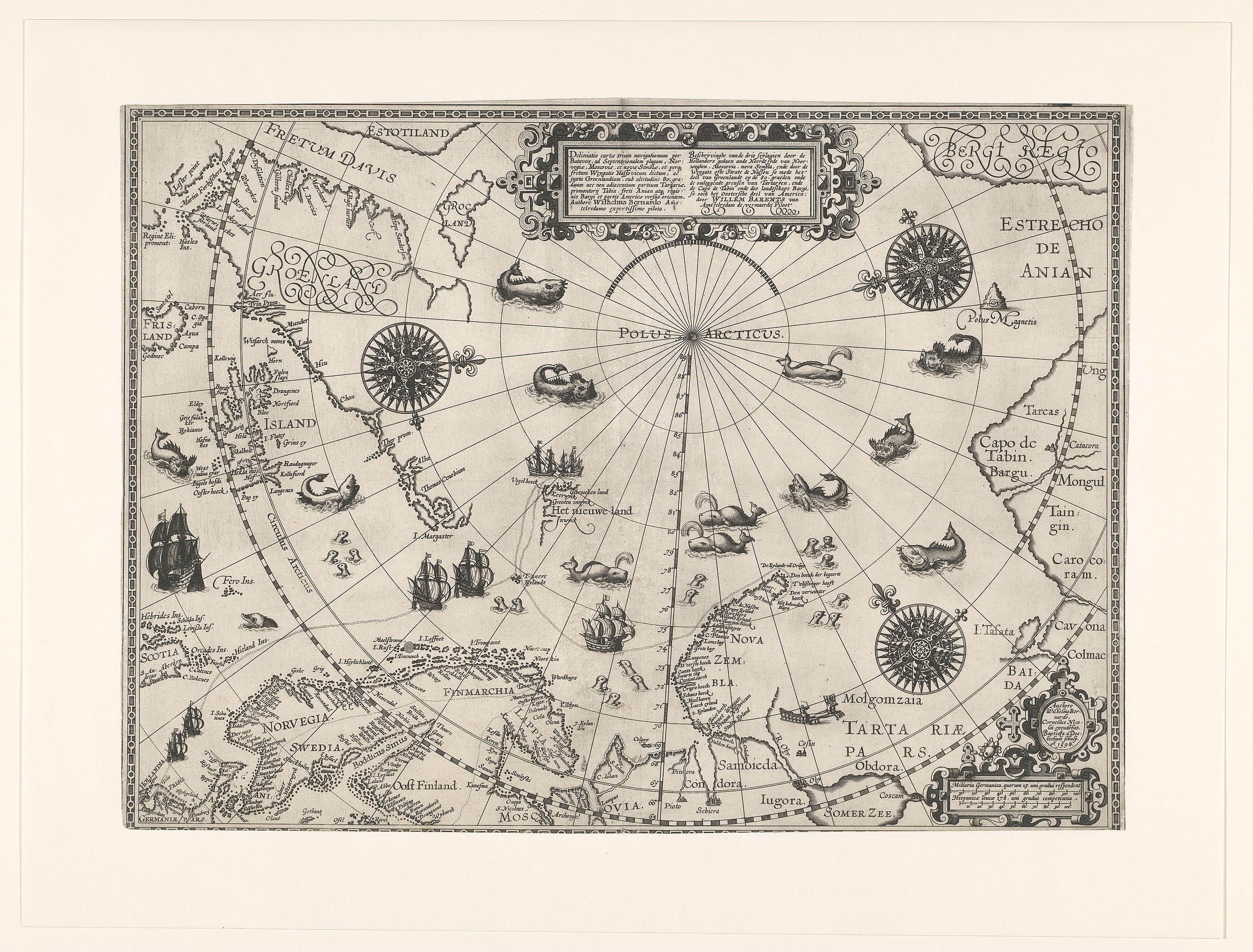
Nederlands: Identificatie Titel(s): Kaart van het Noordpoolgebied, 1598. Beschrijvinghe van de drie seylagien door de Hollanders gedaan (...) door Willem Barendsz (titel op object) Objecttype: kaart Objectnummer: NG-800 Catalogusreferentie: New Hollstein Dutch 983 Omschrijving: Circumpolaire kaart van het Noordpoolgebied linksboven Groenland en een stukje van Noord Amerika, rechts de noordkust van Rusland (met onder andere de Beringstraat die hier de Straat van Anian wordt genoemd). Onder Schotland, Nederland, Scandinavië, Rusland en Nova Zembla; de onontdekte kusten zijn niet ingetekend. De route van Barendsz ingetekend met stippels en schepen. Verder Bereneiland en Spitsbergen. In de zee walvissen, walrussen en zeehonden. Vervaardiging Vervaardiger: cartograaf: Willem Barendsz (vermeld op object), prentmaker: Baptista van Doetechum (vermeld op object), uitgever: Cornelis Claesz. (vermeld op object) Plaats vervaardiging: Amsterdam Datering: 1598 Fysieke kenmerken: ets en gravure Materiaal: papier Techniek: etsen / graveren (drukprocedé) Afmetingen: h 41,7 cm. × b 56,8 cm. Onderwerp Wat: maps of separate countries or regionsmarine charts. Reis van Barendsz en Van Heemskerck in 1596 Wanneer: 1596 - 1597 Waar: Noordpool. ScandinaviëNova Zembla. Rusland Wie: Willem Barendsz. Jacob van Heemskerck Verwerving en rechten Verwerving: aankoop 1971 Copyright: Publiek domein |
| Дата | |
| Источник | Rijksmuseum, from original print. |
| Автор | Baptista van Doetecum's engraving of Cornelis Claesz's drawing of Willem Barentsz's charts. |
| Другие версии |
|

.jpg)
_door_Willem_Barendsz_(titel_op_object),_NG-800.jpg)


_door_Willem_Barendsz_(titel_op_object),_NG-800.jpg&action=edit§ion=1)
Лицензирование
[править]_door_Willem_Barendsz_(titel_op_object),_NG-800.jpg&action=edit§ion=2)
| Этот файл доступен на условиях Creative Commons CC0 1.0 Универсальной передачи в общественное достояние (Universal Public Domain Dedication). | |
| Лица, связанные с работой над этим произведением, решили передать данное произведение в общественное достояние, отказавшись от всех прав на произведение по всему миру в рамках закона об авторских правах (а также связанных и смежных прав), в той степени, которую допускает закон. Вы можете копировать, изменять, распространять, исполнять данное произведение в любых целях, в том числе в коммерческих, без получения на это разрешения автора.
|
История файла
Нажмите на дату/время, чтобы увидеть версию файла от того времени.
| Дата/время | Миниатюра | Размеры | Участник | Примечание | |
|---|---|---|---|---|---|
| текущий | 11:01, 9 ноября 2019 | | 6028 × 4582 (4,04 МБ) | Mr.Nostalgic (обсуждение | вклад) | == {{int:filedesc}} == {{Information |Description={{nl|1=<br><br><big>'''Identificatie'''</big><br>'''Titel(s): '''Kaart van het Noordpoolgebied, 1598Beschrijvinghe van de drie seylagien door de Hollanders gedaan (...) door Willem Barendsz (titel op object)<br>'''Objecttype:''' kaart <br>'''Objectnummer:''' NG-800<br>'''Catalogusreferentie:''' New Hollstein Dutch 983<br>'''Omschrijving:''' Circumpolaire kaart van het Noordpoolgebied linksboven Groenland en een stukje van Noord Amerika, rechts... |
Вы не можете перезаписать этот файл.
Использование файла
Следующие 9 страниц используют этот файл:
- File:1598 map of the Polar Regions by Willem Barentsz.jpg
- File:Barents third voyage.jpg
- File:Barentskartet, 1598 (12068020364).jpg
- File:Barentsz Full Map.jpg
- File:Barentsz arctic map.jpg
- File:Forminsket utgave av Barentskartet - no-nb krt 00487.jpg
- File:Kaart van de landen rond de poolcirkel met de drie reizen van de Nederlanders, 1598 Beschrijvinghe van de drie seylagien door de Hollanders gedaen ande Noordt syde van Noorweghen, Moscovia, nova Sembla, ende door het de, RP-P-OB-80.320.jpg
- File:Kaart van het Noordpoolgebied, 1598 Beschrijvinghe van de drie seylagien door de Hollanders gedaan (..) door Willem Barendsz (titel op object), NG-800.jpg
- File:Pontanus 1611 Arctic Map.jpg
_door_Willem_Barendsz_(titel_op_object),_NG-800.jpg&oldid=891399131)
Категории:
- Overwintering on Nova Zembla by Willem Barentsz, 1596-1597
- Maps in the Rijksmuseum Amsterdam
- Third voyage of Willem Barentsz
- 16th-century maps of the Arctic
- History of Dutch sea fisheries
- 1598 maps
- 1598 maps of Russia
- Old maps of Spitsbergen
- Old maps of Scandinavia
- Maps of Novaya Zemlya
- Old maps of the Arctic
- Old maps of the White Sea
- Maps of the Barents Sea
- Maps of the Greenland Sea
- Old maps of the Arctic Ocean
- Old maps of Svalbard
- 1590s maps of Norway
- 1590s maps of Sweden
- 1590s maps of Denmark
- 1590s maps of Iceland
- 1590s maps of Greenland
- 1590s maps of Scotland
- Magnetic pole
- Strait of Anian
- Davis Strait
- Maps of Frobisher Bay
- Terra incognita
- Phantom islands
- Latin-language maps
- Dutch-language maps
- Animals on maps
- Whales on maps
- Monsters on maps
- Seals in art
- Maps of the Kara Sea
- Maps of the Beaufort Sea
- Maps of Baffin Bay
- Maps of the East Siberian Sea
- Maps of the Laptev Sea
- Maps of the Chukchi Sea
- 1590s maps of Finland
- Baptista van Doetecum
- Cornelis Claesz
- Maps of voyages
- Maps of the North Pole
- Reindeer sleds in art
- Northern Sea Route