File:Kaliningrader Hochstrassen (wider).png
Jump to navigation
Jump to search

Size of this preview: 684 × 599 pixels. Other resolutions: 274 × 240 pixels | 548 × 480 pixels | 877 × 768 pixels | 1,169 × 1,024 pixels | 2,476 × 2,169 pixels.
Original file (2,476 × 2,169 pixels, file size: 738 KB, MIME type: image/png)
Captions
Captions
Add a one-line explanation of what this file represents
| Description |
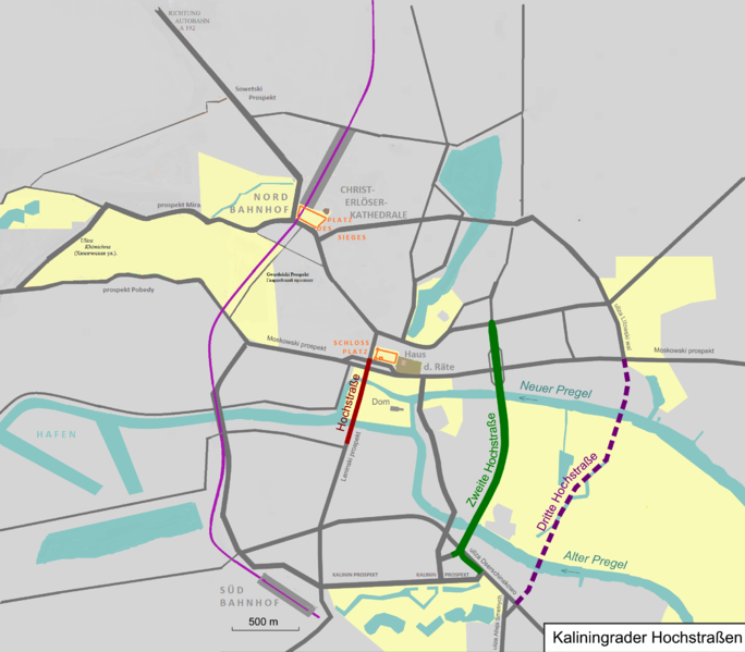
English: General map of elevated highways in en:Kalingrad
Deutsch: Übersichtskarte der en:Kaliningrader Hochstraßen |
| Date | |
| Source |
Map was created using: |
| Author | Pechristener / Feipg.30 |
| Permission (Reusing this file) |
Map data (c) OpenStreetMap (and) contributors, CC-BY-SA. This file is licensed under the Creative Commons Attribution-Share Alike 2.0 Generic license.
|
| Other versions | File:Kaliningrader Hochstrassen.png |
File history
Click on a date/time to view the file as it appeared at that time.
| Date/Time | Thumbnail | Dimensions | User | Comment | |
|---|---|---|---|---|---|
| current | 06:59, 2 October 2015 | | 2,476 × 2,169 (738 KB) | Doc Taxon (talk | contribs) | {{Information |Description ={{en|1=General map of elevated highways in en:Kalingrad}} {{de|1=Übersichtskarte der en:Kaliningrader Hochstraßen}} |Source =Map was created using: *[http://www.openstreetmap.org/index.html?mlat=54... |
You cannot overwrite this file.
File usage on Commons
The following 2 pages use this file:
File usage on other wikis
The following other wikis use this file:
- Usage on de.wikipedia.org
- Usage on fr.wikipedia.org
- Usage on www.wikidata.org
.png&oldid=791645273)