File:Kameyama IC CKK20115-C10-9.JPG
Jump to navigation
Jump to search
Size of this preview: 389 × 600 pixels. Other resolutions: 155 × 240 pixels | 311 × 480 pixels | 498 × 768 pixels | 664 × 1,024 pixels | 2,080 × 3,207 pixels.
Original file (2,080 × 3,207 pixels, file size: 7.39 MB, MIME type: image/jpeg)
Captions
Captions
Add a one-line explanation of what this file represents
Summary
[edit]
| Description |
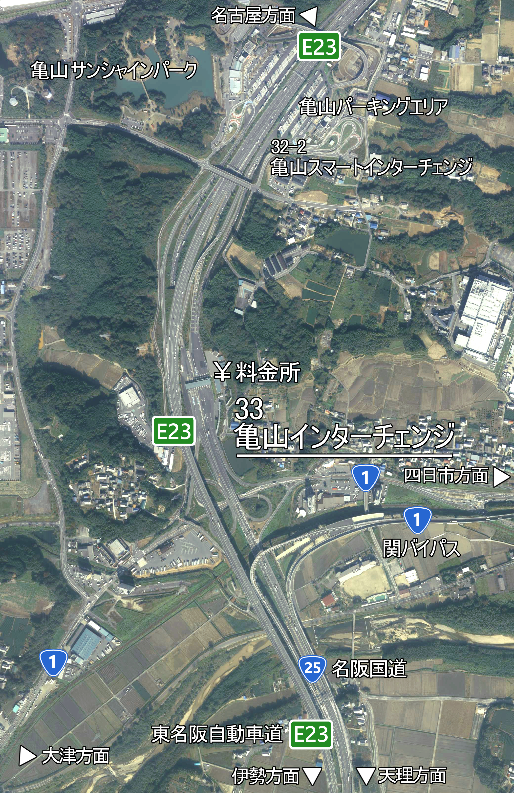
日本語: 亀山インターチェンジの空中写真。国土地理院の空中写真(CKK20115-C10-9)に路線名等を加えている。 |
| Date | |
| Source | 国土画像情報(カラー空中写真)による加工画像 |
| Author | 国土地理院、Oka21000 |
Licensing
[edit]

|
The copyright holder of this file, the Ministry of Land, Infrastructure, Transport and Tourism of Japan, allows anyone to use it for any purpose, provided that the copyright holder is properly attributed. Redistribution, derivative work, commercial use, and all other use is permitted. |
Attribution:
Copyright © National Land Image Information (Color Aerial Photographs), Ministry of Land, Infrastructure, Transport and Tourism
|
 |
This image is copyrighted by the Ministry of Land, Infrastructure, Transport and Tourism of Japan. For terms of use, see the stipulation to use of National Land Information (in Japanese) and message from MLIT (in Japanese and English). When you display this image on an article, include the following phrase in the description: "Made based on National Land Image Information (Color Aerial Photographs), Ministry of Land, Infrastructure, Transport and Tourism".
|
File history
Click on a date/time to view the file as it appeared at that time.
| Date/Time | Thumbnail | Dimensions | User | Comment | |
|---|---|---|---|---|---|
| current | 10:50, 5 May 2019 | | 2,080 × 3,207 (7.39 MB) | Oka21000 (talk | contribs) | {{Information |description ={{ja|1=亀山インターチェンジの空中写真。国土地理院の空中写真(CKK20115-C10-9)に路線名等を加えている。}} |date =2011-11-04 |source =国土画像情報(カラー空中写真)による加工画像 |author =国土地理院、Oka21000 }} Category:Higashi-Meihan Expressway Category:Route 25 (Japan) |
You cannot overwrite this file.
File usage on Commons
There are no pages that use this file.
File usage on other wikis
The following other wikis use this file:
- Usage on ja.wikipedia.org