File:Karlinsky okres mapa 1850.jpg
Jump to navigation
Jump to search

Size of this preview: 466 × 600 pixels. Other resolutions: 186 × 240 pixels | 373 × 480 pixels | 597 × 768 pixels | 796 × 1,024 pixels | 1,591 × 2,048 pixels | 5,250 × 6,757 pixels.
Original file (5,250 × 6,757 pixels, file size: 9.05 MB, MIME type: image/jpeg)
Captions
Captions
Add a one-line explanation of what this file represents
Summary
[edit]
| Description |
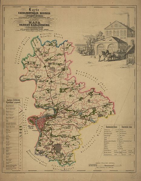
Čeština: Mapa karlínského okresu z r. 1850 s obrazem cukrovaru |
| Date | |
| Source | http://katalog.ahmp.cz/pragapublica/permalink?xid=7E88DBDCFBD511DF822500166F1163D4 |
| Author | credit “J.E.Wagner ryl” = engraved; possibly cartographer Jan Eduard Wagner (1835–1904) |
Licensing
[edit]
|
This work is in the public domain in its country of origin and other countries and areas where the copyright term is the author's life plus 70 years or fewer. | |
| This file has been identified as being free of known restrictions under copyright law, including all related and neighboring rights. | |
File history
Click on a date/time to view the file as it appeared at that time.
| Date/Time | Thumbnail | Dimensions | User | Comment | |
|---|---|---|---|---|---|
| current | 19:43, 3 November 2012 | | 5,250 × 6,757 (9.05 MB) | Octopus moldavicus (talk | contribs) |
You cannot overwrite this file.
File usage on Commons
The following page uses this file:
File usage on other wikis
The following other wikis use this file:
- Usage on cs.wikipedia.org
- Usage on de.wikipedia.org
- Usage on es.wikipedia.org