File:Karst Hydrogeologie Schema2.jpg

Original file (1,800 × 1,200 pixels, file size: 1.12 MB, MIME type: image/jpeg)
Captions
Captions
Summary
[edit]
| Description |
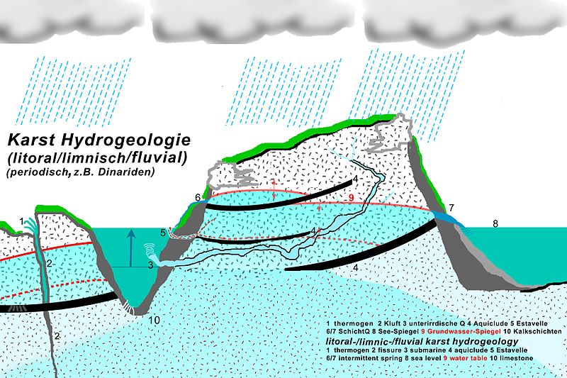
Deutsch: Hydrogeologisches Schema subaquatischer Karstgänge und Karstquellen Beispiel starke Verkarstung und normaler oder starker periodischer Niederschlag. Solange der Wasserdruck stark genug ist, dringt das Wasser des Karstwasser-Gangs in das Gewässer ein. Ist das Gewässer salzig, entsteht durch Vermischung Brackwasser, welches immer auch noch einige Meter im Karstwasser-Gang messbar ist. Bei großem Karstwasserdruck ist an der Gewässeroberfläche eine Verwirbelung zu sehen und der Salzgehalt kann im Karstwasser-Gang gering sein (immer aber noch messbar). English: Hydrogeologic schema of subaquaeous karst conduits and karst springs. There are a few subaquaeous karst springs in Greece and many at the northern hemisphere of the Mediterranean Sea. In case a spring is coastal or submarine (saline water), brackish water is even measured at maximum outflow up the karst conduit. |
| Date | |
| Source | Own work |
| Author | ulrichstill |
Licensing
[edit]
- You are free:
- to share – to copy, distribute and transmit the work
- to remix – to adapt the work
- Under the following conditions:
- attribution – You must give appropriate credit, provide a link to the license, and indicate if changes were made. You may do so in any reasonable manner, but not in any way that suggests the licensor endorses you or your use.
- share alike – If you remix, transform, or build upon the material, you must distribute your contributions under the same or compatible license as the original.

File history
Click on a date/time to view the file as it appeared at that time.
| Date/Time | Thumbnail | Dimensions | User | Comment | |
|---|---|---|---|---|---|
| current | 17:22, 16 December 2016 | | 1,800 × 1,200 (1.12 MB) | Ulrichstill (talk | contribs) | User created page with UploadWizard |
You cannot overwrite this file.
File usage on Commons
There are no pages that use this file.
File usage on other wikis
The following other wikis use this file:
- Usage on de.wikipedia.org