File:Karst peaks with sea of clouds at sunrise, South view from the top of Mount Nam Xay, Vang Vieng, Laos.jpg
跳转到导航
跳转到搜索
本预览的尺寸:800 × 533像素。 其他分辨率:320 × 213像素 | 640 × 427像素 | 1,024 × 683像素 | 1,280 × 853像素 | 2,560 × 1,707像素 | 6,129 × 4,086像素。
原始文件 (6,129 × 4,086像素,文件大小:6.4 MB,MIME类型:image/jpeg)
说明
说明
添加一行文字以描述该文件所表现的内容
Karst peaks with sea of clouds at sunrise, South view from the top of Mount Nam Xay, Vang Vieng, Laos
摘要[编辑]
| 描述 |
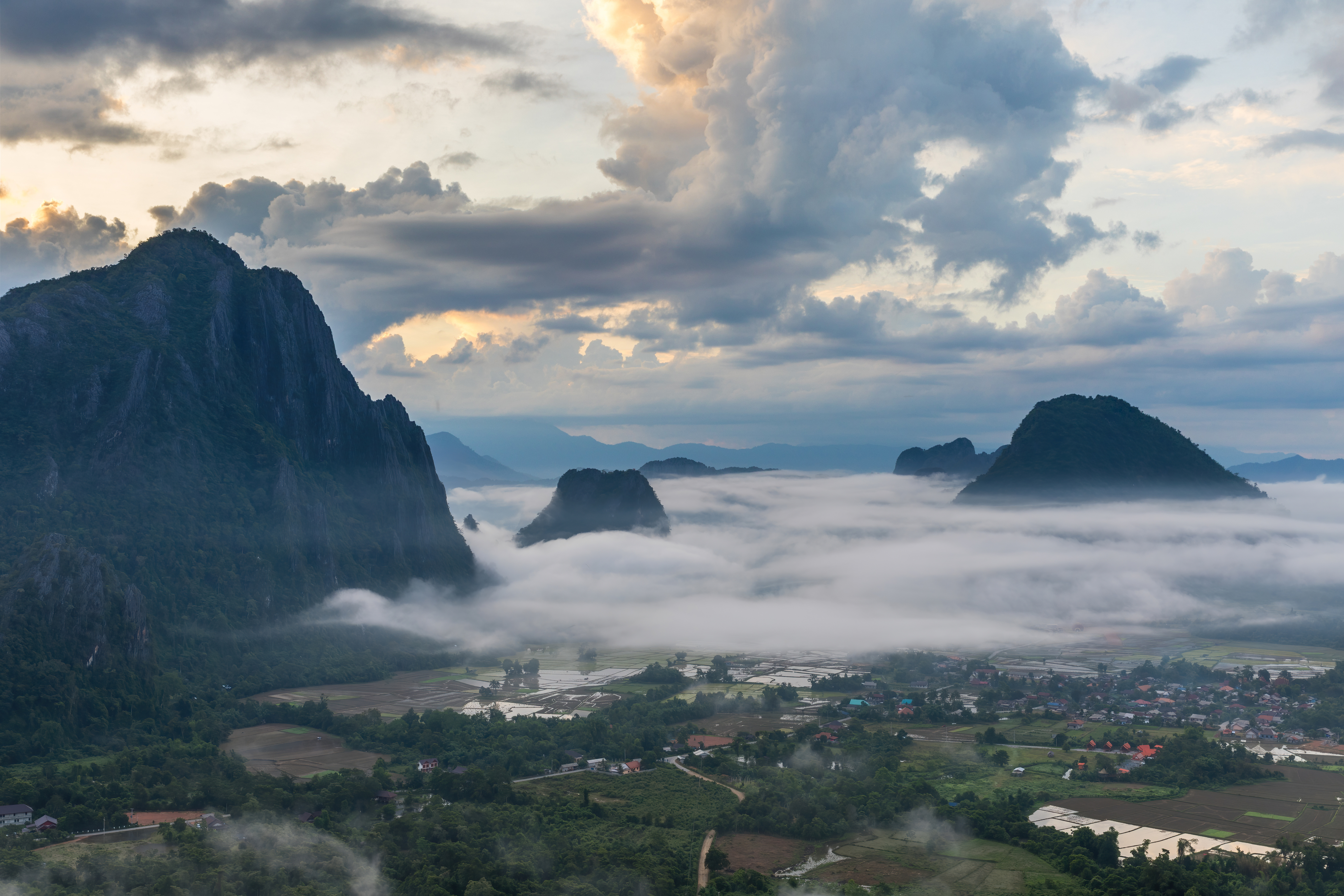
English: Karst peaks with colorful clouds above and sea of clouds below, covering the rice fields, at sunrise, South view from the top of Mount Nam Xay, during the monsoon, in Vang Vieng, Vientiane Province, Laos.
Français : Pitons karstiques au lever du soleil, avec des nuages colorés au-dessus et une mer de nuages au-dessous, recouvrant les rizières inondées, vue sud depuis le sommet du Mont Nam Xay, durant la mousson, à Vang Vieng, Province de Vientiane, Laos. |
| 日期 | |
| 来源 | 自己的作品 |
| 作者 | Basile Morin |
| 相机位置 | | 在以下服务上查看本图像和附近其他图像: OpenStreetMap |
|---|
|
许可协议[编辑]
我,本作品著作权人,特此采用以下许可协议发表本作品:
本文件采用知识共享署名-相同方式共享 4.0 国际许可协议授权。
- 您可以自由地:
- 共享 – 复制、发行并传播本作品
- 修改 – 改编作品
- 惟须遵守下列条件:
- 署名 – 您必须对作品进行署名,提供授权条款的链接,并说明是否对原始内容进行了更改。您可以用任何合理的方式来署名,但不得以任何方式表明许可人认可您或您的使用。
- 相同方式共享 – 如果您再混合、转换或者基于本作品进行创作,您必须以与原先许可协议相同或相兼容的许可协议分发您贡献的作品。
文件历史
点击某个日期/时间查看对应时刻的文件。
| 日期/时间 | 缩略图 | 大小 | 用户 | 备注 | |
|---|---|---|---|---|---|
| 当前 | 2021年2月19日 (五) 00:12 | | 6,129 × 4,086(6.4 MB) | Basile Morin(留言 | 贡献) | Minor improvement : blown highlights dialed down at the upper left corner |
| 2020年8月9日 (日) 09:30 |  | 6,129 × 4,086(5.85 MB) | Basile Morin(留言 | 贡献) | Uploaded own work with UploadWizard |
您不可以覆盖此文件。
文件用途
以下19个页面使用本文件:
- User:Derbeth/Various favs
- User:Dronebogus/Favorites
- User:Firefly/2020-B
- User:Meiræ/21
- User:Nardog/PotY
- User talk:Basile Morin/Archive 7 (2020)
- Commons:Featured picture candidates/File:Karst peaks with sea of clouds at sunrise, South view from the top of Mount Nam Xay, Vang Vieng, Laos.jpg
- Commons:Featured picture candidates/Log/December 2020
- Commons:Featured pictures/Natural phenomena
- Commons:Featured pictures/chronological/2020-B
- Commons:Featured pictures/chronological/December 2020
- Commons:Picture of the Year/2020/Candidates
- Commons:Picture of the Year/2020/R1/Gallery/2020-B
- Commons:Picture of the Year/2020/R1/Gallery/ALL
- Commons:Picture of the Year/2020/R1/Gallery/M12
- Commons:Picture of the Year/2020/R1/Gallery/Settlements
- Commons:Picture of the Year/2020/R1/v/Karst peaks with sea of clouds at sunrise, South view from the top of Mount Nam Xay, Vang Vieng, Laos.jpg
- Commons:Quality images/Subject/Sunsets
- Commons:Quality images candidates/Archives August 12 2020
全域文件用途
以下其他wiki使用此文件:
- bcl.wiktionary.org上的用途
- bn.wikibooks.org上的用途
- de.wikipedia.org上的用途
- en.wikipedia.org上的用途
- Vang Vieng
- Wikipedia:Featured pictures/Places/Urban
- Talk:Vang Vieng
- User talk:Basile Morin
- User:Basile Morin
- Wikipedia:Featured picture candidates/February-2021
- Wikipedia:Featured picture candidates/Karst peaks with sea of clouds at sunrise, Vang Vieng, Laos
- Wikipedia:Featured pictures thumbs/70
- Wikipedia:Picture of the day/November 2023
- Template:POTD/2023-11-16
- User talk:TheFreeWorld/Archive 1
- fa.wikibooks.org上的用途
- fr.wikipedia.org上的用途
- hy.wikibooks.org上的用途
- lb.wikipedia.org上的用途
- uk.wikipedia.org上的用途
- www.wikidata.org上的用途
- zh.wikipedia.org上的用途