File:Karta Su tasqyny.png
Jump to navigation
Jump to search

Size of this preview: 800 × 467 pixels. Other resolutions: 320 × 187 pixels | 640 × 373 pixels | 1,200 × 700 pixels.
Original file (1,200 × 700 pixels, file size: 155 KB, MIME type: image/png)
Captions
Captions
Add a one-line explanation of what this file represents
Summary[edit]
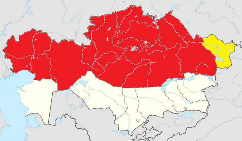
| Description |
Русский: Карта Казахстана, документирующяя регионы во время паводков в Центральной Азии (2024).
Регионы, где было объявлено Чрезвычайное положение. Регионы под угрозой затопления English: Map of Kazakhstan, marking the subdivisions during the 2024 Central Asian floods.
Regions, where a State of Emergency was announced Regions at risk of being flooded |
| Date | |
| Source |
Own work |
| Author | Нурасылл |

Licensing[edit]
I, the copyright holder of this work, hereby publish it under the following license:
| This file is made available under the Creative Commons CC0 1.0 Universal Public Domain Dedication. | |
| The person who associated a work with this deed has dedicated the work to the public domain by waiving all of their rights to the work worldwide under copyright law, including all related and neighboring rights, to the extent allowed by law. You can copy, modify, distribute and perform the work, even for commercial purposes, all without asking permission.
|
File history
Click on a date/time to view the file as it appeared at that time.
| Date/Time | Thumbnail | Dimensions | User | Comment | |
|---|---|---|---|---|---|
| current | 09:17, 7 April 2024 | | 1,200 × 700 (155 KB) | Нурасылл (talk | contribs) | Uploaded own work with UploadWizard |
You cannot overwrite this file.
File usage
There are no pages that use this file.
Global file usage
The following other wikis use this file:
- Usage on kk.wikipedia.org
- Usage on ky.wikipedia.org
- Usage on ru.wikipedia.org
- Usage on uz.wikipedia.org