File:KarteOberamtSchaumburgNalbacherTalL1030659 (2).JPG
Jump to navigation
Jump to search

Size of this preview: 799 × 600 pixels. Other resolutions: 320 × 240 pixels | 639 × 480 pixels | 1,023 × 768 pixels | 1,280 × 961 pixels | 2,560 × 1,922 pixels | 3,444 × 2,586 pixels.
Original file (3,444 × 2,586 pixels, file size: 2.2 MB, MIME type: image/jpeg)
Captions
Captions
Add a one-line explanation of what this file represents
Summary
[edit].JPG&action=edit§ion=1)
| Description |
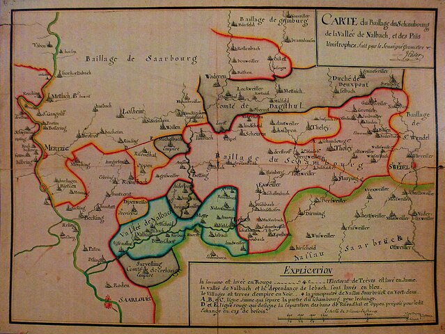
Deutsch: Karte des Oberamtes Schaumburg (Baillage du Schaumbourg) mit der Darstellung des Nalbacher Tales (Vallée de Nalbach) sowie der umliegenden Gebiete (Pais limitrophes), gefertigt durch den Geometer J. Coster um das Jahr 1779; Die rote Linie begrenzt das Gebiet Lothringens, die gelbe Linie markiert das Gebiet des Erzbistums und Kurfüstentums Trier, blau gekennzeichnet ist das Nalbacher Tal mit den Talorten Diefflen (Tiffendhal), Nalbach, Piesbach (Pisbach), Bettstadt (Bettscheid), Bilsdorf (Büllersdorff) und Körprich (Kirburg) sowie die von von Lebach abhängigen Gebiete. Grün begrenzt ist die Grafschaft Nassau-Saarbrücken, schwarz markiert sind die Reichsherrschaften (Landeshauptarchiv Koblenz, Bestand 702, Karte 7301). |
| Date | |
| Source | Own work |
| Author | Oktobersonne |
Licensing
[edit].JPG&action=edit§ion=2)
I, the copyright holder of this work, hereby publish it under the following license:
This file is licensed under the Creative Commons Attribution-Share Alike 4.0 International license.
- You are free:
- to share – to copy, distribute and transmit the work
- to remix – to adapt the work
- Under the following conditions:
- attribution – You must give appropriate credit, provide a link to the license, and indicate if changes were made. You may do so in any reasonable manner, but not in any way that suggests the licensor endorses you or your use.
- share alike – If you remix, transform, or build upon the material, you must distribute your contributions under the same or compatible license as the original.
File history
Click on a date/time to view the file as it appeared at that time.
| Date/Time | Thumbnail | Dimensions | User | Comment | |
|---|---|---|---|---|---|
| current | 17:42, 17 October 2015 | | 3,444 × 2,586 (2.2 MB) | Oktobersonne (talk | contribs) | User created page with UploadWizard |
You cannot overwrite this file.
File usage on Commons
There are no pages that use this file.
File usage on other wikis
The following other wikis use this file:
- Usage on de.wikipedia.org
- Usage on fr.wikipedia.org
.JPG&oldid=459020957)