File:Karte Krimdeutsche 01.jpg

Original file (2,737 × 2,057 pixels, file size: 4.18 MB, MIME type: image/jpeg)
Captions
Captions
| Description |
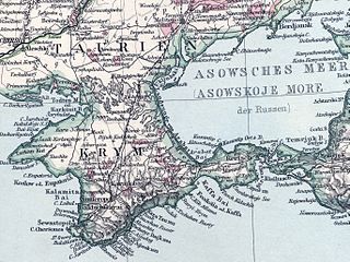
Deutsch: Siedlungsgebiete der Krimdeutschen um 1890 (rot) im Süden der Ukraine, Russisches Reich |
||||
| Date | |||||
| Source | Adolf Stieler’s Handatlas, Justus Perthes, Gotha 1891, Blatt 49 | ||||
| Author | Unknown author | ||||
| Permission (Reusing this file) |
|
||||
| Other versions | Karte Schwarzmeerdeutsche 01.jpg | ||||
File history
Click on a date/time to view the file as it appeared at that time.
| Date/Time | Thumbnail | Dimensions | User | Comment | |
|---|---|---|---|---|---|
| current | 14:14, 27 February 2014 | | 2,737 × 2,057 (4.18 MB) | Oltau (talk | contribs) | {{Information |Description={{de|1=Siedlungsgebiete der Krimdeutschen im Süden der Ukraine, Russisches Reich}} |Source=Adolf Stieler’s Handatlas, Justus Perthes, Gotha 1891, [http://www.maproom.org/00/09/present.php?m=0049 Blatt 49] |Date=1891 |Autho... |
You cannot overwrite this file.
File usage on Commons
There are no pages that use this file.
File usage on other wikis
The following other wikis use this file:
- Usage on de.wikipedia.org