File:Karte Pelikan Abbazia und Umgebung.jpg
Jump to navigation
Jump to search

Size of this preview: 720 × 599 pixels. Other resolutions: 288 × 240 pixels | 577 × 480 pixels | 923 × 768 pixels | 1,230 × 1,024 pixels | 2,460 × 2,048 pixels | 14,773 × 12,298 pixels.
Original file (14,773 × 12,298 pixels, file size: 84.88 MB, MIME type: image/jpeg)
Captions
Captions
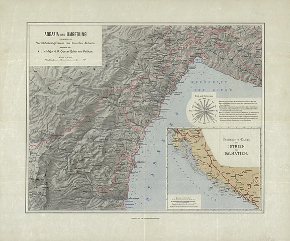
Map of Abbazia
Summary
[edit]
| Warning | The original file is very high-resolution. It might not load properly or could cause your browser to freeze when opened at full size. |
|---|
| Description |
Deutsch: Landkarte von Abbazia und Umgebung.
Herausgegeben von Kaiserlich-Königliches Militär-Geographisches Institut (Wien) und Verschönerungsverein des Kurortes Abbazia Maßstab 1:30.000English: Map of Abbazia and sourrounding area
1:30000 scale |
| Date | between 1908 and 1913 |
| Source | https://polona.pl/item/abbazia-und-umgebung,NDc5MTUxNDA/0/#info:metadata |
| Author | Gustav Edler von Pelikan (1840–1919) |
Licensing
[edit]
|
This work is in the public domain in its country of origin and other countries and areas where the copyright term is the author's life plus 100 years or fewer. This work is in the public domain in the United States because it was published (or registered with the U.S. Copyright Office) before January 1, 1929. | |
| This file has been identified as being free of known restrictions under copyright law, including all related and neighboring rights. | |
File history
Click on a date/time to view the file as it appeared at that time.
| Date/Time | Thumbnail | Dimensions | User | Comment | |
|---|---|---|---|---|---|
| current | 17:33, 4 December 2021 | | 14,773 × 12,298 (84.88 MB) | Herbert Ortner (talk | contribs) | Uploaded a work by Gustav Edler von Pelikan (1840–1919) from https://polona.pl/item/abbazia-und-umgebung,NDc5MTUxNDA/0/#info:metadata with UploadWizard |
You cannot overwrite this file.
File usage on Commons
There are no pages that use this file.