File:Karte Rheinhessenbahn.png
Jump to navigation
Jump to search

Size of this preview: 673 × 600 pixels. Other resolutions: 269 × 240 pixels | 539 × 480 pixels | 862 × 768 pixels | 1,149 × 1,024 pixels | 2,298 × 2,048 pixels | 4,507 × 4,017 pixels.
Original file (4,507 × 4,017 pixels, file size: 10.12 MB, MIME type: image/png)
Captions
Captions
Add a one-line explanation of what this file represents
Summary
[edit]
| Description |
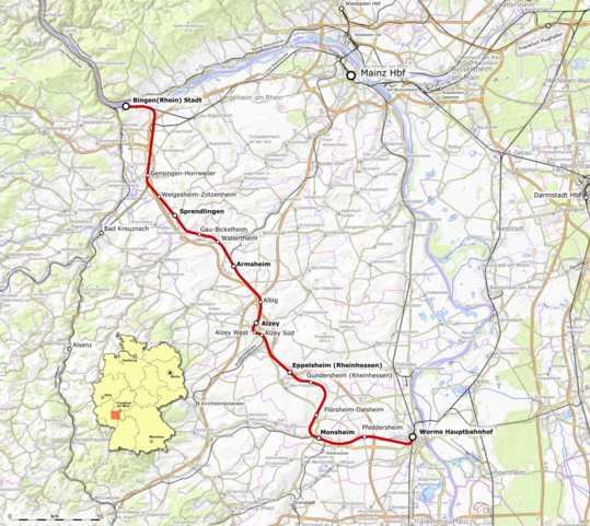
Deutsch: Karte der Rheinhessenbahn, das ist die Bahnstrecke Worms–Bingen Stadt |
|||||||||
| Date | ||||||||||
| Source | Openstreetmap | |||||||||
| Creator |
|
|||||||||
| Geotemporal data | ||||||||||
| Bounding box |
|
|||||||||
| Georeferencing | ||||||||||
| This work is licensed under the Open Database License (summary). |
This file is licensed under the Creative Commons Attribution-Share Alike 2.0 Generic license.
- You are free:
- to share – to copy, distribute and transmit the work
- to remix – to adapt the work
- Under the following conditions:
- attribution – You must give appropriate credit, provide a link to the license, and indicate if changes were made. You may do so in any reasonable manner, but not in any way that suggests the licensor endorses you or your use.
- share alike – If you remix, transform, or build upon the material, you must distribute your contributions under the same or compatible license as the original.
File history
Click on a date/time to view the file as it appeared at that time.
| Date/Time | Thumbnail | Dimensions | User | Comment | |
|---|---|---|---|---|---|
| current | 15:09, 21 October 2018 | | 4,507 × 4,017 (10.12 MB) | Pechristener (talk | contribs) | location map added |
| 09:58, 21 October 2018 |  | 4,507 × 4,017 (10.13 MB) | Pechristener (talk | contribs) | == {{int:filedesc}} == {{Map |Description={{de| Karte der {{w|Rheinhessenbahn||de}}, das ist die Bahnstrecke Worms–Bingen Stadt}} |Source= Openstreetmap |Date= 2018-10-20 |Author= * Background: Openstreetmap contributors * Rendering: {{u|Pechristener}} |Permission= |other_versions= }} {{ODbL}} {{cc-by-sa-2.0}} Category:Rheinhessenbahn |
You cannot overwrite this file.
File usage on Commons
The following page uses this file:
File usage on other wikis
The following other wikis use this file:
- Usage on de.wikipedia.org
- Usage on www.wikidata.org