File:Karte S-Bahnnetze in Deutschland.svg
Przejdź do nawigacji
Przejdź do wyszukiwania

Wielkość pliku podglądu PNG dla pliku SVG: 428 × 599 pikseli Inne rozdzielczości: 171 × 240 pikseli | 343 × 480 pikseli | 549 × 768 pikseli | 731 × 1024 pikseli | 1463 × 2048 pikseli | 1726 × 2416 pikseli.
Rozmiar pierwotny (Plik SVG, nominalnie 1726 × 2416 pikseli, rozmiar pliku: 1,63 MB)
Podpisy
Podpisy
Dodaj jednolinijkowe objaśnienie tego, co ten plik pokazuje
| Opis |
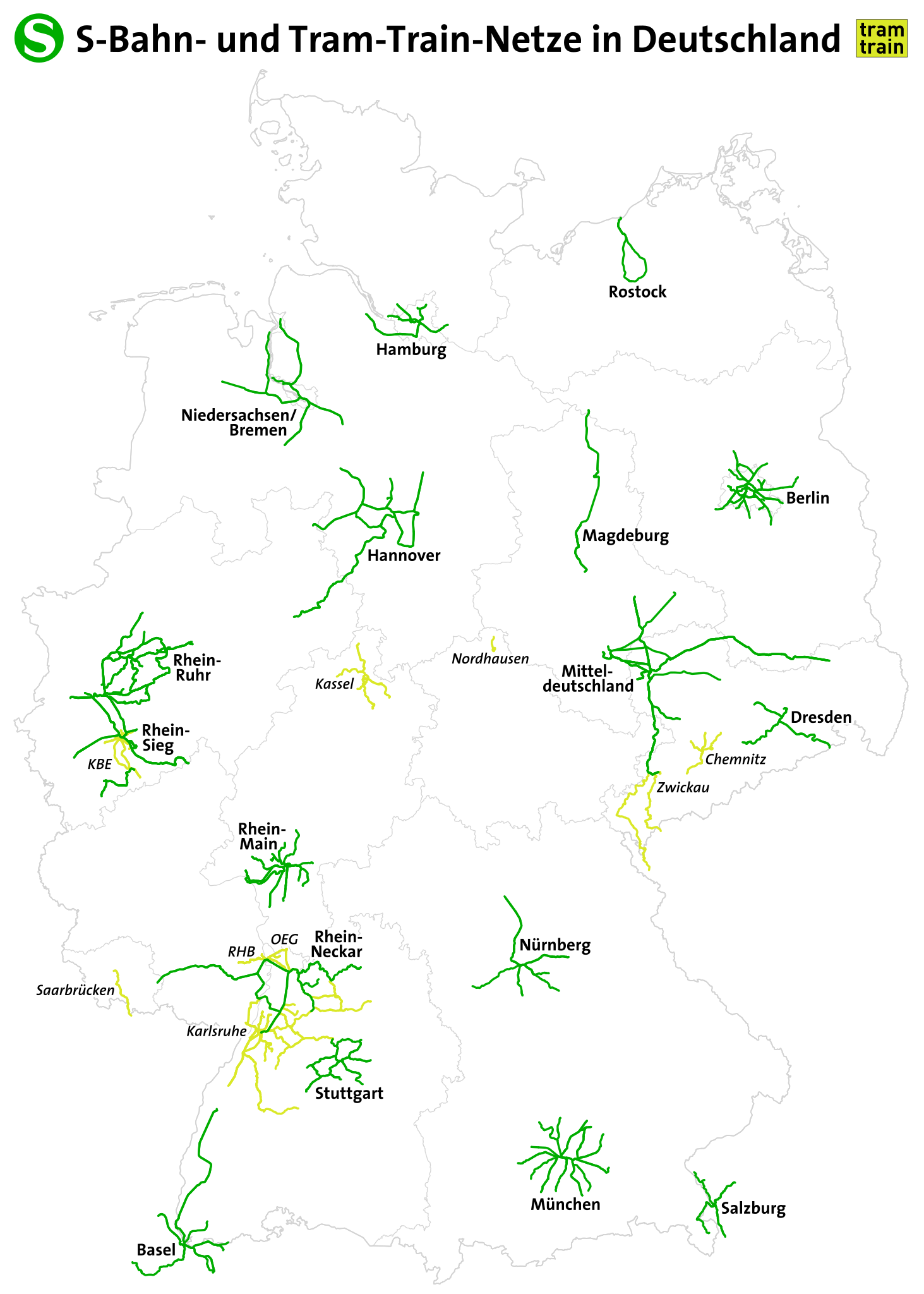
Deutsch:
S-Bahnnetze und Tram-Train-Netze in Deutschland English: S-Bahn routes in Germany |
|||
| Data | see file history | |||
| Źródło | Praca własna, using OpenStreetMap data | |||
| Autor | Maximilian Dörrbecker (Chumwa) | |||
| Licencja (Ponowne użycie tego pliku) |
Ten plik udostępniony jest na licencji Creative Commons Uznanie autorstwa – Na tych samych warunkach 2.0.
|
|||
| Inne wersje |


Historia pliku
Kliknij na odpowiedniej dacie/czasie, aby zobaczyć wersję pliku z tamtego okresu.
| Data/czas | Miniatura | Wymiary | Użytkownik | Opis | |
|---|---|---|---|---|---|
| aktualny | 21:08, 2 paź 2022 | | 1726 × 2416 (1,63 MB) | Benfri (dyskusja | edycje) | Reverted to version as of 20:16, 17 November 2018 (UTC) |
| 20:52, 2 paź 2022 |  | 744 × 1106 (7,68 MB) | Benfri (dyskusja | edycje) | update | |
| 20:16, 17 lis 2018 |  | 1726 × 2416 (1,63 MB) | Chumwa (dyskusja | edycje) | update | |
| 21:06, 25 lip 2016 |  | 1726 × 2416 (1,63 MB) | Chumwa (dyskusja | edycje) | ||
| 20:47, 23 kwi 2016 |  | 1726 × 2416 (1,63 MB) | Chumwa (dyskusja | edycje) | ||
| 17:37, 23 kwi 2016 |  | 1726 × 2416 (1,63 MB) | Chumwa (dyskusja | edycje) | ||
| 22:47, 21 kwi 2016 |  | 998 × 1320 (5,59 MB) | Chumwa (dyskusja | edycje) | ||
| 21:44, 21 kwi 2016 |  | 998 × 1320 (5,58 MB) | Chumwa (dyskusja | edycje) | ||
| 17:54, 21 kwi 2016 |  | 998 × 1320 (5,73 MB) | Chumwa (dyskusja | edycje) | {{Information |Description = {{de|1=S-Bahnstrecken in Deutschland}} {{en|1=S-Bahn routes in Germany}} |Source={{own}}, using OpenStreetMap data |Date = see file history |Author = Maximilian Dörrbecker ([[:de:U... |
Nie możesz nadpisać tego pliku.
Lokalne wykorzystanie pliku
Następujące strony korzystają z tego pliku:
- User:Chumwa/Gallery
- User:Chumwa/OgreBot/Potential transport maps/2016 April 21-30
- User:Chumwa/OgreBot/Potential transport maps/2016 July 21-31
- User:Chumwa/OgreBot/Potential transport maps/2018 November 11-20
- User:Chumwa/OgreBot/Public transport information/2016 April 21-30
- User:Chumwa/OgreBot/Public transport information/2016 July 21-31
- User:Chumwa/OgreBot/Public transport information/2018 November 11-20
- User:Chumwa/OgreBot/Public transport information/2022 October 1-10
- User:Chumwa/OgreBot/Transport Maps/2016 April 21-30
- User:Chumwa/OgreBot/Transport Maps/2016 July 21-31
- User:Chumwa/OgreBot/Transport Maps/2018 November 11-20
- User:Chumwa/OgreBot/Transport Maps/2022 October 1-10
- User:Chumwa/OgreBot/Travel and communication maps/2016 April 21-30
- User:Chumwa/OgreBot/Travel and communication maps/2016 July 21-31
- User:Chumwa/OgreBot/Travel and communication maps/2018 November 11-20
- User:Chumwa/OtherVersions - OePNV-Karten
- File:Carte des transports urbains en France.png
- File:Dtl sbahn.svg
- File:Greater China Rapid Transit.svg
- File:Karte Metro-, Tram- und Obussysteme.svg
- File:Karte S-Bahnnetze in Deutschland.svg
- File:Karte der ÖPNV-Systeme in Deutschland 2008.png
- File:Karte der ÖPNV-Systeme in Lateinamerika.png
- File:Karte der ÖPNV-Systeme in Nordafrika.png
- File:Karte der ÖPNV-Systeme in Spanien und Portugal.png
- File:Karte der ÖPNV-Systeme in den Staaten der ehemaligen Sowjetunion.png
- File:Karte der ÖPNV-Systeme in den USA.png
- File:Karte ÖPNV-Netze Deutschland.svg
- File:Karte ÖPNV-Systeme in Italien.png
- File:Karte ÖPNV-Systeme in der Türkei.png
- File:Metro, tram a trolejbusy v ČR.jpg
- File:Metro map of China.svg
- File:Núcleos de Cercanías de Renfe.svg
- File:OePNVSystemeDeutschland.png
- File:OePNVSystemeDeutschlandJanuar2003.jpg
- File:OePNVSystemeFrankreich-fr.png
- File:OePNVSystemeFrankreich.png
- File:OePNVSystemeJapanJanuar2003.png
- File:OePNVSystemePolenMai2007.png
- File:Public transport system map of the USA.png
- File:Public transport systems of Italy.png
- File:Rail networks USA map.svg
- File:Réseaux de trolleybus en France.png
- File:S-Bahnen copy.svg (przekierowanie do pliku)
- File:Transports urbains de France.png
- File:Tranvía en España.svg
- File:ÖPNV-System in den Benelux-Staaten.png
- File:ÖPNV-Systeme Tschechische Republik.png
- File:ÖPNV-Systeme auf den Britischen Inseln.png
- File:ÖPNV-Systeme in China.png
- File:ÖPNV-Systeme in Korea.png
- File:ÖPNV-Systeme in Südosteuropa.png
- File:ÖPNV-Südkorea de.svg
Globalne wykorzystanie pliku
Ten plik jest wykorzystywany także w innych projektach wiki:
- Wykorzystanie na de.wikipedia.org
- Wykorzystanie na en.wikipedia.org
- Wykorzystanie na hu.wikipedia.org
- Wykorzystanie na it.wikipedia.org
- Wykorzystanie na ka.wikipedia.org
- Wykorzystanie na ku.wikipedia.org
- Wykorzystanie na ms.wikipedia.org
- Wykorzystanie na no.wikipedia.org
- Wykorzystanie na pl.wikipedia.org
- Wykorzystanie na ru.wikipedia.org
- Wykorzystanie na sk.wikipedia.org
- Wykorzystanie na zh.wikipedia.org