File:Karte S-Bahnnetze in Deutschland.svg
跳至導覽
跳至搜尋

此 SVG 檔案的 PNG 預覽的大小:428 × 599 像素。 其他解析度:171 × 240 像素 | 343 × 480 像素 | 549 × 768 像素 | 731 × 1,024 像素 | 1,463 × 2,048 像素 | 1,726 × 2,416 像素。
原始檔案 (SVG 檔案,表面大小:1,726 × 2,416 像素,檔案大小:1.63 MB)
說明
說明
添加單行說明來描述出檔案所代表的內容
| 描述 |
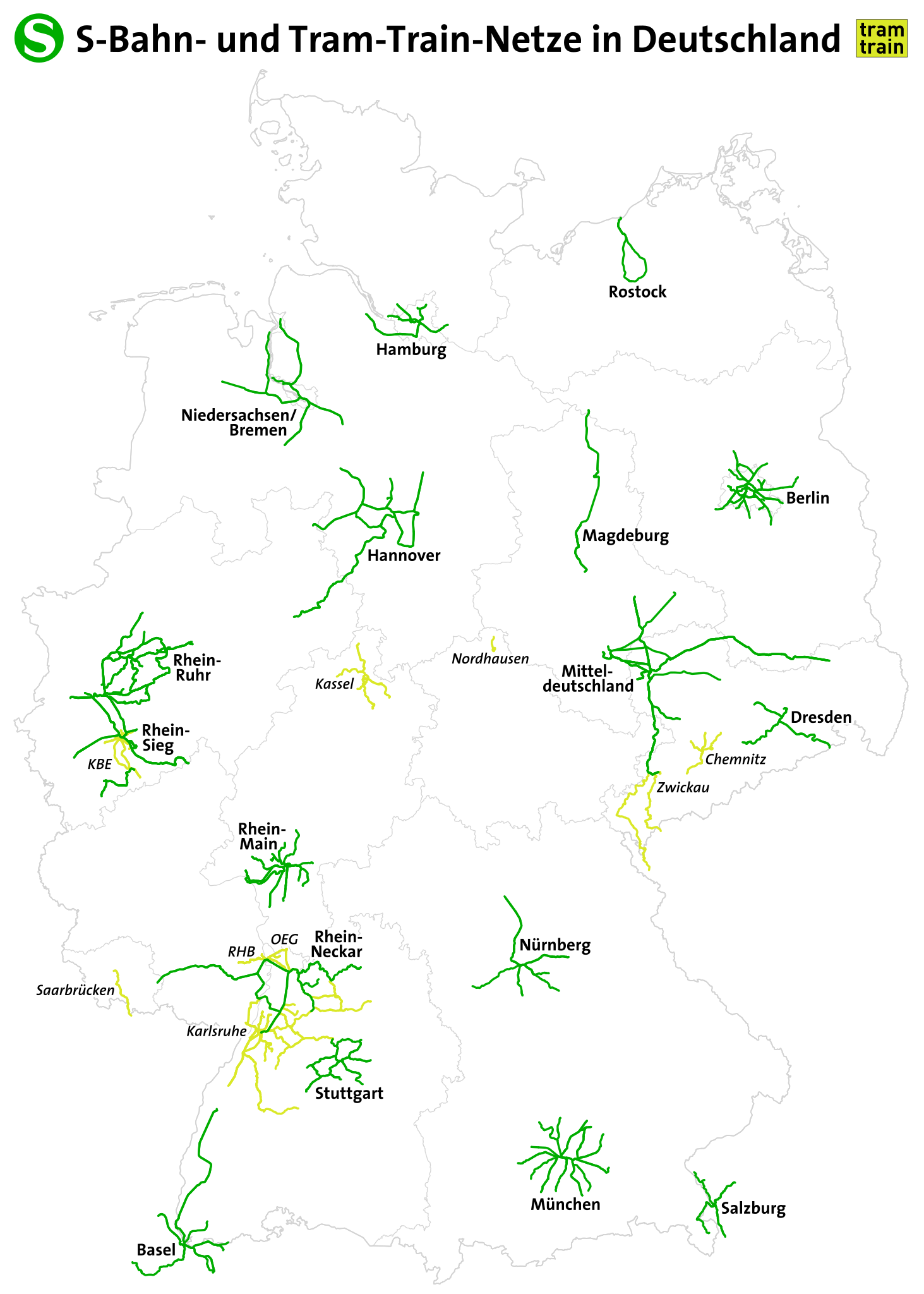
Deutsch:
S-Bahnnetze und Tram-Train-Netze in Deutschland English: S-Bahn routes in Germany |
|||
| 日期 | see file history | |||
| 來源 | 自己的作品, using OpenStreetMap data | |||
| 作者 | Maximilian Dörrbecker (Chumwa) | |||
| 授權許可 (重用此檔案) |
此檔案採用創用CC 姓名標示-相同方式分享 2.0 通用版授權條款。
|
|||
| 其他版本 |


檔案歷史
點選日期/時間以檢視該時間的檔案版本。
| 日期/時間 | 縮圖 | 尺寸 | 使用者 | 備註 | |
|---|---|---|---|---|---|
| 目前 | 2022年10月2日 (日) 21:08 | | 1,726 × 2,416(1.63 MB) | Benfri(留言 | 貢獻) | Reverted to version as of 20:16, 17 November 2018 (UTC) |
| 2022年10月2日 (日) 20:52 |  | 744 × 1,106(7.68 MB) | Benfri(留言 | 貢獻) | update | |
| 2018年11月17日 (六) 20:16 |  | 1,726 × 2,416(1.63 MB) | Chumwa(留言 | 貢獻) | update | |
| 2016年7月25日 (一) 21:06 |  | 1,726 × 2,416(1.63 MB) | Chumwa(留言 | 貢獻) | ||
| 2016年4月23日 (六) 20:47 |  | 1,726 × 2,416(1.63 MB) | Chumwa(留言 | 貢獻) | ||
| 2016年4月23日 (六) 17:37 |  | 1,726 × 2,416(1.63 MB) | Chumwa(留言 | 貢獻) | ||
| 2016年4月21日 (四) 22:47 |  | 998 × 1,320(5.59 MB) | Chumwa(留言 | 貢獻) | ||
| 2016年4月21日 (四) 21:44 |  | 998 × 1,320(5.58 MB) | Chumwa(留言 | 貢獻) | ||
| 2016年4月21日 (四) 17:54 |  | 998 × 1,320(5.73 MB) | Chumwa(留言 | 貢獻) | {{Information |Description = {{de|1=S-Bahnstrecken in Deutschland}} {{en|1=S-Bahn routes in Germany}} |Source={{own}}, using OpenStreetMap data |Date = see file history |Author = Maximilian Dörrbecker ([[:de:U... |
無法覆蓋此檔案。
檔案用途
下列53個頁面有用到此檔案:
- User:Chumwa/Gallery
- User:Chumwa/OgreBot/Potential transport maps/2016 April 21-30
- User:Chumwa/OgreBot/Potential transport maps/2016 July 21-31
- User:Chumwa/OgreBot/Potential transport maps/2018 November 11-20
- User:Chumwa/OgreBot/Public transport information/2016 April 21-30
- User:Chumwa/OgreBot/Public transport information/2016 July 21-31
- User:Chumwa/OgreBot/Public transport information/2018 November 11-20
- User:Chumwa/OgreBot/Public transport information/2022 October 1-10
- User:Chumwa/OgreBot/Transport Maps/2016 April 21-30
- User:Chumwa/OgreBot/Transport Maps/2016 July 21-31
- User:Chumwa/OgreBot/Transport Maps/2018 November 11-20
- User:Chumwa/OgreBot/Transport Maps/2022 October 1-10
- User:Chumwa/OgreBot/Travel and communication maps/2016 April 21-30
- User:Chumwa/OgreBot/Travel and communication maps/2016 July 21-31
- User:Chumwa/OgreBot/Travel and communication maps/2018 November 11-20
- User:Chumwa/OtherVersions - OePNV-Karten
- File:Carte des transports urbains en France.png
- File:Dtl sbahn.svg
- File:Greater China Rapid Transit.svg
- File:Karte Metro-, Tram- und Obussysteme.svg
- File:Karte S-Bahnnetze in Deutschland.svg
- File:Karte der ÖPNV-Systeme in Deutschland 2008.png
- File:Karte der ÖPNV-Systeme in Lateinamerika.png
- File:Karte der ÖPNV-Systeme in Nordafrika.png
- File:Karte der ÖPNV-Systeme in Spanien und Portugal.png
- File:Karte der ÖPNV-Systeme in den Staaten der ehemaligen Sowjetunion.png
- File:Karte der ÖPNV-Systeme in den USA.png
- File:Karte ÖPNV-Netze Deutschland.svg
- File:Karte ÖPNV-Systeme in Italien.png
- File:Karte ÖPNV-Systeme in der Türkei.png
- File:Metro, tram a trolejbusy v ČR.jpg
- File:Metro map of China.svg
- File:Núcleos de Cercanías de Renfe.svg
- File:OePNVSystemeDeutschland.png
- File:OePNVSystemeDeutschlandJanuar2003.jpg
- File:OePNVSystemeFrankreich-fr.png
- File:OePNVSystemeFrankreich.png
- File:OePNVSystemeJapanJanuar2003.png
- File:OePNVSystemePolenMai2007.png
- File:Public transport system map of the USA.png
- File:Public transport systems of Italy.png
- File:Rail networks USA map.svg
- File:Réseaux de trolleybus en France.png
- File:S-Bahnen copy.svg (檔案重新導向)
- File:Transports urbains de France.png
- File:Tranvía en España.svg
- File:ÖPNV-System in den Benelux-Staaten.png
- File:ÖPNV-Systeme Tschechische Republik.png
- File:ÖPNV-Systeme auf den Britischen Inseln.png
- File:ÖPNV-Systeme in China.png
- File:ÖPNV-Systeme in Korea.png
- File:ÖPNV-Systeme in Südosteuropa.png
- File:ÖPNV-Südkorea de.svg
全域檔案使用狀況
以下其他 wiki 使用了這個檔案:
- de.wikipedia.org 的使用狀況
- en.wikipedia.org 的使用狀況
- hu.wikipedia.org 的使用狀況
- it.wikipedia.org 的使用狀況
- ka.wikipedia.org 的使用狀況
- ku.wikipedia.org 的使用狀況
- ms.wikipedia.org 的使用狀況
- no.wikipedia.org 的使用狀況
- pl.wikipedia.org 的使用狀況
- ru.wikipedia.org 的使用狀況
- sk.wikipedia.org 的使用狀況
- zh.wikipedia.org 的使用狀況