File:Karte Winterthur Schlosstal.svg
Jump to navigation
Jump to search

Size of this PNG preview of this SVG file: 553 × 599 pixels. Other resolutions: 221 × 240 pixels | 443 × 480 pixels | 709 × 768 pixels | 945 × 1,024 pixels | 1,890 × 2,048 pixels | 1,329 × 1,440 pixels.
Original file (SVG file, nominally 1,329 × 1,440 pixels, file size: 4.7 MB)
Captions
Captions
Add a one-line explanation of what this file represents
Summary[edit]
| Description |
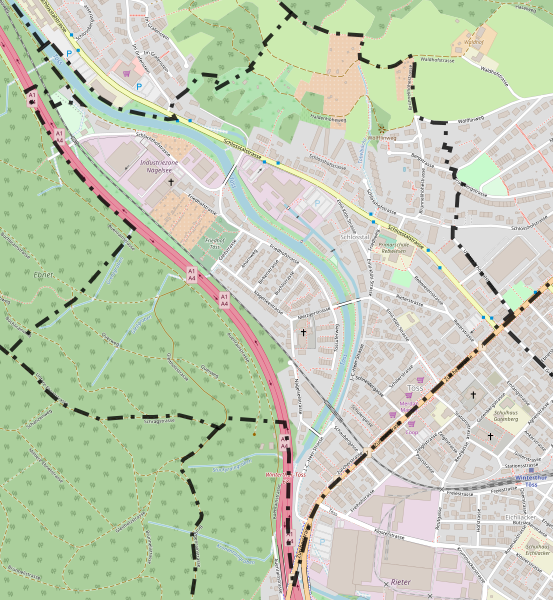
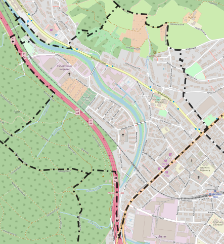
Deutsch: Karte des Winterthurer Quartier Schlosstal mit eingezeichneter Grenze; basierend auf einer Karte des OpenStreetMap-Projektes
English: Map from the quarter Schlosstal of the city Winterthur with borders; based on a map of the OpenStreetMap-project |
|||||||||
| Date | ||||||||||
| Source | You may find a page on the OpenStreetMap wiki page for Schlosstal | |||||||||
| Creator |
OpenStreetMap-Mitwirkende; zusätzliche Grenzen von User:Fundriver OpenStreetMap contributors |
|||||||||
| Permission (Reusing this file) |
OpenStreetMap data is available under the Open Database License (details). Map tiles are licensed under the Creative Commons Attribution-ShareAlike 2.0 license (CC-BY-SA 2.0).
This file is licensed under the Creative Commons Attribution-Share Alike 2.0 Generic license.
|
|||||||||
| Geotemporal data | ||||||||||
| Bounding box |
|
|||||||||
| Georeferencing | If inappropriate please set warp_status = skip to hide. | |||||||||
File history
Click on a date/time to view the file as it appeared at that time.
| Date/Time | Thumbnail | Dimensions | User | Comment | |
|---|---|---|---|---|---|
| current | 09:04, 13 May 2019 | | 1,329 × 1,440 (4.7 MB) | Fundriver (talk | contribs) | Korrektur Grenzlinien |
| 08:16, 14 August 2018 |  | 1,329 × 1,440 (4.7 MB) | Fundriver (talk | contribs) | Korrekturversuch | |
| 19:23, 9 August 2018 |  | 1,329 × 1,440 (4.7 MB) | Fundriver (talk | contribs) | {{OpenStreetMap |name = Schlosstal |location = Quartier Schlosstal, Winterthur |description = {{de|1=Karte des Winterthurer Quartier Schlosstal mit eingezeichneter Grenze; basierend auf einer Karte des OpenStreetMap-Projektes}} {{en|1=Map from the quarter Schlosstal of the city Winterthur with borders; based on a map of the OpenStreetMap-project}} |top = 47.500324 |bottom = 47.48697 |left = 8.69260 |right = 8.71078 |date = 2018-08-09 |authors = OpenStreetMap-Mitwirkende; zusä... |
You cannot overwrite this file.
File usage on Commons
The following 10 pages use this file:
- User:Chumwa/OgreBot/Potential transport maps/2018 August 1-10
- User:Chumwa/OgreBot/Potential transport maps/2018 August 11-20
- User:Chumwa/OgreBot/Potential transport maps/2019 May 11-20
- User:Chumwa/OgreBot/Transport Maps/2018 August 1-10
- User:Chumwa/OgreBot/Transport Maps/2018 August 11-20
- User:Chumwa/OgreBot/Transport Maps/2019 May 11-20
- User:Chumwa/OgreBot/Travel and communication maps/2018 August 1-10
- User:Chumwa/OgreBot/Travel and communication maps/2018 August 11-20
- User:Chumwa/OgreBot/Travel and communication maps/2019 May 11-20
- File:Karte Winterthur Schlosstal 1.svg (file redirect)
File usage on other wikis
The following other wikis use this file:
- Usage on de.wikipedia.org