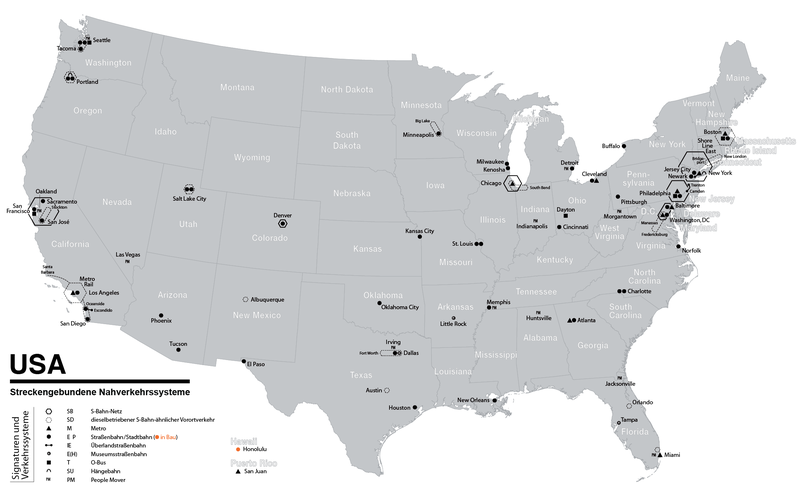
File:Karte der ÖPNV-Systeme in den USA.png
- Fichier
- Historique du fichier
- Utilisations locales du fichier
- Utilisations du fichier sur d’autres wikis
- Métadonnées

Fichier d’origine (2 204 × 1 353 pixels, taille du fichier : 440 kio, type MIME : image/png)
Légendes
Légendes
| DescriptionKarte der ÖPNV-Systeme in den USA.png |
|
| Date | see file history |
| Source | Travail personnel |
| Auteur | Maximilian Dörrbecker (Chumwa) |
| Autorisation (Réutilisation de ce fichier) |
Moi, en tant que détenteur des droits d’auteur sur cette œuvre, je la publie sous la licence suivante : Ce fichier est disponible selon les termes de la licence Creative Commons Attribution – Partage dans les Mêmes Conditions 2.5 Générique
Sie dürfen das Bild zu den folgenden Bedingungen nutzen:
|
| Autres versions |
China
Czech Republic France
Germany
Italy
Japan
Korea Poland
Spain & Portugal
Turkey
British Isles Former Soviet Union
Balkans
North Africa
Latin America
United States of America
|
Historique du fichier
Cliquer sur une date et heure pour voir le fichier tel qu'il était à ce moment-là.
| Date et heure | Vignette | Dimensions | Utilisateur | Commentaire | |
|---|---|---|---|---|---|
| actuel | 3 juin 2019 à 19:51 |  | 2 204 × 1 353 (440 kio) | Chumwa (d | contributions) | update |
| 30 janvier 2018 à 19:04 |  | 2 204 × 1 353 (439 kio) | Chumwa (d | contributions) | update | |
| 16 décembre 2017 à 08:32 |  | 2 204 × 1 353 (438 kio) | Chumwa (d | contributions) | +Milwaukee | |
| 10 décembre 2014 à 10:22 |  | 2 204 × 1 353 (292 kio) | Kopiersperre (d | contributions) | optipng | |
| 30 novembre 2014 à 06:08 |  | 2 204 × 1 353 (443 kio) | Chumwa (d | contributions) | correction: Nashville | |
| 28 novembre 2014 à 05:40 |  | 2 204 × 1 353 (444 kio) | Chumwa (d | contributions) | +Memphis | |
| 27 novembre 2014 à 22:23 |  | 2 204 × 1 353 (443 kio) | Chumwa (d | contributions) | update | |
| 30 mars 2010 à 19:47 |  | 2 172 × 1 353 (407 kio) | Chumwa (d | contributions) | commuter rails and some tramway systems added | |
| 5 juin 2009 à 22:37 |  | 2 172 × 1 353 (384 kio) | Chumwa (d | contributions) | {{Information |Description= *{{ de }} Karte der streckengebundenen Nahverkehrssysteme (S-Bahn, U-Bahn, Stadtbahn, Straßenbahn, O-Bus) in den USA (Stand: Juni 2009) *{{ en }} Map of fixed-route public transport systems (suburban railways, Rapid Transit an |
Vous ne pouvez pas remplacer ce fichier.
Utilisations locales du fichier
Les 46 pages suivantes utilisent ce fichier :
- User:Chumwa/Gallery
- User:Chumwa/OgreBot/Potential transport maps/2017 December 11-20
- User:Chumwa/OgreBot/Potential transport maps/2018 January 21-31
- User:Chumwa/OgreBot/Potential transport maps/2019 June 1-10
- User:Chumwa/OgreBot/Public transport information/2017 December 11-20
- User:Chumwa/OgreBot/Public transport information/2018 January 21-31
- User:Chumwa/OgreBot/Public transport information/2019 June 1-10
- User:Chumwa/OgreBot/Transport Maps/2017 December 11-20
- User:Chumwa/OgreBot/Transport Maps/2018 January 21-31
- User:Chumwa/OgreBot/Transport Maps/2019 June 1-10
- User:Chumwa/OgreBot/Travel and communication maps/2017 December 11-20
- User:Chumwa/OgreBot/Travel and communication maps/2018 January 21-31
- User:Chumwa/OgreBot/Travel and communication maps/2019 June 1-10
- User:Chumwa/OtherVersions - OePNV-Karten
- File:Carte des transports urbains en France.png
- File:Greater China Rapid Transit.svg
- File:Karte der ÖPNV-Systeme in Deutschland 2008.png
- File:Karte der ÖPNV-Systeme in Lateinamerika.png
- File:Karte der ÖPNV-Systeme in Nordafrika.png
- File:Karte der ÖPNV-Systeme in Spanien und Portugal.png
- File:Karte der ÖPNV-Systeme in den Staaten der ehemaligen Sowjetunion.png
- File:Karte der ÖPNV-Systeme in den USA.png
- File:Karte ÖPNV-Systeme in Italien.png
- File:Karte ÖPNV-Systeme in der Türkei.png
- File:Metro, tram a trolejbusy v ČR.jpg
- File:Metro map of China.svg
- File:Núcleos de Cercanías de Renfe.svg
- File:OePNVSystemeDeutschland.png
- File:OePNVSystemeDeutschlandJanuar2003.jpg
- File:OePNVSystemeFrankreich-fr.png
- File:OePNVSystemeFrankreich.png
- File:OePNVSystemeJapanJanuar2003.png
- File:OePNVSystemePolenMai2007.png
- File:Public transport system map of the USA.png
- File:Public transport systems of Italy.png
- File:Rail networks USA map.svg
- File:Réseaux de trolleybus en France.png
- File:Transports urbains de France.png
- File:Tranvía en España.svg
- File:ÖPNV-System in den Benelux-Staaten.png
- File:ÖPNV-Systeme Tschechische Republik.png
- File:ÖPNV-Systeme auf den Britischen Inseln.png
- File:ÖPNV-Systeme in China.png
- File:ÖPNV-Systeme in Korea.png
- File:ÖPNV-Systeme in Südosteuropa.png
- File:ÖPNV-Südkorea de.svg
Utilisations du fichier sur d’autres wikis
Les autres wikis suivants utilisent ce fichier :
- Utilisation sur cs.wikipedia.org
- Utilisation sur de.wikipedia.org
- Utilisation sur en.wikipedia.org
- Utilisation sur fr.wikipedia.org
- Utilisation sur ja.wikipedia.org
- Utilisation sur nl.wikipedia.org
- Utilisation sur sk.wikipedia.org
Métadonnées
Ce fichier contient des informations supplémentaires, probablement ajoutées par l'appareil photo numérique ou le numériseur utilisé pour le créer.
Si le fichier a été modifié depuis son état original, certains détails peuvent ne pas refléter entièrement l'image modifiée.
| Résolution horizontale | 59,06 pt/cm |
|---|---|
| Résolution verticale | 59,06 pt/cm |
| Logiciel utilisé |


