File:Porenkowo Pomorsko 1.png
(Redirected from File:Kaschubei heute.png)
No higher resolution available.
Porenkowo_Pomorsko_1.png (358 × 563 pixels, file size: 111 KB, MIME type: image/png)
Captions
Captions
Add a one-line explanation of what this file represents

|
This map image could be re-created using vector graphics as an SVG file. This has several advantages; see Commons:Media for cleanup for more information. If an SVG form of this image is available, please upload it and afterwards replace this template with
{{vector version available|new image name}}.
It is recommended to name the SVG file “Porenkowo Pomorsko 1.svg”—then the template Vector version available (or Vva) does not need the new image name parameter. |
Summary
[edit]
| Description |
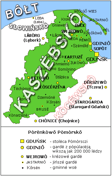
Polski: Zasięg kaszubszczyzny pod koniec XX wieku. Mapa oparta na pracy Jana Modrawskiego "Geografia współczesnych Kaszub" / Gdańsk 1999 |
| Source | http://kaszubia.com/ & http://csb.wikipedia.org/wiki/%C3%92br%C3%B4zk:Porenkowo_Pomorsko_1.png |
| Author | csb:Brëkòwnik:Kaszeba & csb:Brëkòwnik:Ùczk |
Licensing
[edit]
I, the copyright holder of this work, hereby publish it under the following license:
This file is licensed under the Creative Commons Attribution 2.5 Generic license.
- You are free:
- to share – to copy, distribute and transmit the work
- to remix – to adapt the work
- Under the following conditions:
- attribution – You must give appropriate credit, provide a link to the license, and indicate if changes were made. You may do so in any reasonable manner, but not in any way that suggests the licensor endorses you or your use.
File history
Click on a date/time to view the file as it appeared at that time.
| Date/Time | Thumbnail | Dimensions | User | Comment | |
|---|---|---|---|---|---|
| current | 20:45, 4 February 2007 | | 358 × 563 (111 KB) | Kaszeba (talk | contribs) | {{Information |Description=Karta Pòrénkòwi Pòmòrsczi z zaznaczenim dzysdniowi Kaszëbsczi ôs dôwny zemi Słowińców. Karta òsta zrechtowónô na spòdlim rezultatów badérowaniów J. Mòrdawsczégò. |Source=http://csb.wikipedia.org/wiki/%C3%92b |
| 17:34, 3 February 2007 |  | 358 × 563 (111 KB) | Spars (talk | contribs) | {{Information |Description=Mapa Kaszub |Source=http://de.wikipedia.org/wiki/Bild:Kaschubei_heute.png |Date= |Author= |Permission= |other_versions= }} |
You cannot overwrite this file.
File usage on Commons
The following page uses this file:
- File:Kaschubei heute.png (file redirect)
File usage on other wikis
The following other wikis use this file:
- Usage on be-tarask.wikipedia.org
- Usage on be.wikipedia.org
- Usage on br.wikipedia.org
- Usage on csb.wikipedia.org
- Usage on cs.wikipedia.org
- Usage on dsb.wikipedia.org
- Usage on eo.wikipedia.org
- Usage on et.wikipedia.org
- Usage on fr.wikipedia.org
- Usage on hr.wikipedia.org
- Usage on hsb.wikipedia.org
- Usage on hu.wikipedia.org
- Usage on it.wikipedia.org
- Usage on oc.wikipedia.org
- Usage on sk.wikipedia.org
- Usage on szl.wikipedia.org
- Usage on zh.wikipedia.org