File:Kay 2004-10-05 1445Z.jpg
Jump to navigation
Jump to search

Size of this preview: 600 × 600 pixels. Other resolutions: 240 × 240 pixels | 480 × 480 pixels | 768 × 768 pixels | 1,024 × 1,024 pixels.
Original file (1,024 × 1,024 pixels, file size: 711 KB, MIME type: image/jpeg)
Captions
Captions
Add a one-line explanation of what this file represents
Summary
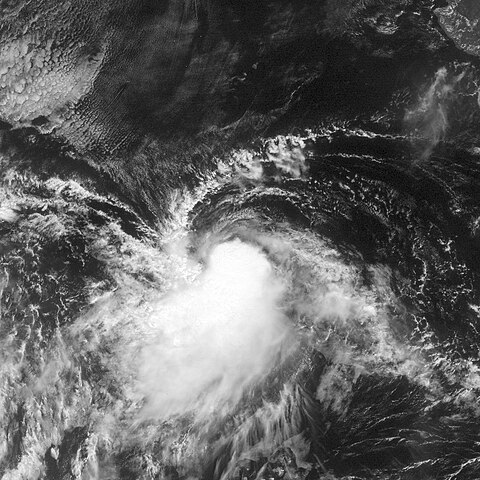
[edit]| Description | This image of Tropical Storm Kay was captured by the GOES-12 satellite on October 5, 2004 at 1445 UTC. Kay was located in the Pacific Ocean with peak intensity winds of 45 mph and a minimum pressure of approximately 1004 mb. | ||||||
| Date | |||||||
| Source | http://www.nrlmry.navy.mil/tc_pages/tc_home.html | ||||||
| Author | Naval Research Laboratory | ||||||
| Permission (Reusing this file) |
|
||||||

File history
Click on a date/time to view the file as it appeared at that time.
| Date/Time | Thumbnail | Dimensions | User | Comment | |
|---|---|---|---|---|---|
| current | 22:52, 3 June 2012 | | 1,024 × 1,024 (711 KB) | Supportstorm (talk | contribs) | image didn't renew |
| 22:50, 3 June 2012 |  | 1,024 × 1,024 (711 KB) | Supportstorm (talk | contribs) | Better version | |
| 14:55, 24 September 2006 |  | 898 × 898 (261 KB) | Good kitty (talk | contribs) | peak intensity | |
| 18:35, 6 July 2006 |  | 800 × 800 (147 KB) | Hurricanehink (talk | contribs) | {{Information |Description=Tropical Storm Key Priro to becoming a tropical storm |Source=http://www.nrlmry.navy.mil/tc-bin/tc_display.cgi?BASIN=EPAC&STORM_NAME=14E.KAY&ACTION=Latest_Photos&ACTIVES=None&MOSAIC_SCALE=20&PHOT=yes&ATCF_BASIN=ep&CGI=TC&AGE=Pre |
You cannot overwrite this file.
File usage on Commons
The following page uses this file:
- File:Tropical Storm Kay (2004).JPG (file redirect)
.JPG&redirect=no)
File usage on other wikis
The following other wikis use this file:
- Usage on de.wikipedia.org
- Usage on pt.wikipedia.org
- Usage on zh.wikipedia.org