File:Khalid ibn al-Walid's Ridda campaign.png
Jump to navigation
Jump to search

Size of this preview: 800 × 539 pixels. Other resolutions: 320 × 216 pixels | 640 × 431 pixels | 1,024 × 690 pixels | 1,515 × 1,021 pixels.
Original file (1,515 × 1,021 pixels, file size: 808 KB, MIME type: image/png)
Captions
Captions
Add a one-line explanation of what this file represents
Summary[edit]
| Description |
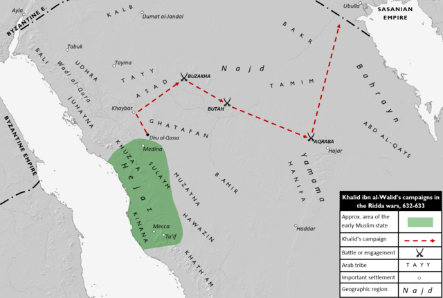
English: Map showing the general itinerary of the early Muslim general Khalid ibn al-Walid's campaigns during the Ridda wars. The campaigns were launched against Arab tribes opposed to or not yet submitted to the early Muslim state based in Medina. Khalid's campaigns specifically targeted the tribes of Tayy, Asad, Ghatafan, Amir, Tamim and Hanifa, whose dwelling territory is shown on the map along with those of other major tribes. The approximate area of the early Muslim state is shaded in green.
Sources:
|
| Date | |
| Source | Own work |
| Author | Al Ameer son |
- Other information
English: Free base map from Demis World Map Server.
Licensing[edit]
I, the copyright holder of this work, hereby publish it under the following licenses:

|
Permission is granted to copy, distribute and/or modify this document under the terms of the GNU Free Documentation License, Version 1.2 or any later version published by the Free Software Foundation; with no Invariant Sections, no Front-Cover Texts, and no Back-Cover Texts. A copy of the license is included in the section entitled GNU Free Documentation License. |
This file is licensed under the Creative Commons Attribution-Share Alike 4.0 International license.
- You are free:
- to share – to copy, distribute and transmit the work
- to remix – to adapt the work
- Under the following conditions:
- attribution – You must give appropriate credit, provide a link to the license, and indicate if changes were made. You may do so in any reasonable manner, but not in any way that suggests the licensor endorses you or your use.
- share alike – If you remix, transform, or build upon the material, you must distribute your contributions under the same or compatible license as the original.
You may select the license of your choice.
File history
Click on a date/time to view the file as it appeared at that time.
| Date/Time | Thumbnail | Dimensions | User | Comment | |
|---|---|---|---|---|---|
| current | 16:16, 2 February 2022 | | 1,515 × 1,021 (808 KB) | Al Ameer son (talk | contribs) | {{subst:Upload marker added by en.wp UW}} {{Information |Description = {{en|Map showing the general itinerary of the early Muslim general Khalid ibn al-Walid's campaigns during the Ridda wars. The campaigns were launched against Arab tribes opposed to or not yet submitted to the early Muslim state based in Medina. Khalid's campaigns specifically targeted the tribes of Tayy, Asad, Ghatafan, Amir, Tamim and Hanifa, whose dwelling territory is shown on the map along with those of other major tri... |
You cannot overwrite this file.
File usage on Commons
There are no pages that use this file.
File usage on other wikis
The following other wikis use this file:
- Usage on en.wikipedia.org
- Usage on id.wikipedia.org
- Usage on ko.wikipedia.org