File:Khazar1.png
Jump to navigation
Jump to search
No higher resolution available.
Khazar1.png (498 × 448 pixels, file size: 12 KB, MIME type: image/png)
Captions
Captions
Add a one-line explanation of what this file represents
Summary
[edit]
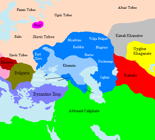
Map showing approximate extent of the w:Khazar w:Khaganate (light blue) and its sphere of influence (dark blue) at its height, c. 820 CE. Polity names in white indicate client-states or tribes of Khazaria.
The source is one of the GFDL World Maps on [1].
Licensing
[edit]
Taken from en:File:Khazar1.png, created by en.wikipedia.org user Briangotts, who released it under the GPL.
| This file is licensed under the Creative Commons Attribution-Share Alike 3.0 Unported license. Subject to disclaimers. | ||
| ||
| This licensing tag was added to this file as part of the GFDL licensing update. |

|
Permission is granted to copy, distribute and/or modify this document under the terms of the GNU Free Documentation License, Version 1.2 or any later version published by the Free Software Foundation; with no Invariant Sections, no Front-Cover Texts, and no Back-Cover Texts. A copy of the license is included in the section entitled GNU Free Documentation License. Subject to disclaimers. |
File history
Click on a date/time to view the file as it appeared at that time.
| Date/Time | Thumbnail | Dimensions | User | Comment | |
|---|---|---|---|---|---|
| current | 15:29, 16 June 2022 | | 498 × 448 (12 KB) | Web3Punkt11 (talk | contribs) | restore white font labels because "Polity names in white indicate client-states or tribes of Khazaria." --User:Jrohr (originator) |
| 10:44, 11 October 2012 |  | 498 × 448 (19 KB) | MicBy67 (talk | contribs) | Hintergrundfarben angepasst | |
| 09:10, 17 January 2006 |  | 498 × 448 (17 KB) | Jrohr (talk | contribs) | == Summary == Map showing approximate extent of the w:Khazar w:Khaganate (light blue) and its sphere of influence (dark blue) at its height, c. 820 CE. Polity names in white indicate client-states or tribes of Khazaria. [[Category:Historical map |
You cannot overwrite this file.
File usage on Commons
The following 2 pages use this file:
File usage on other wikis
The following other wikis use this file:
- Usage on de.wikipedia.org
- Usage on en.wikipedia.org
- Usage on fi.wikipedia.org
- Usage on fr.wikipedia.org
- Usage on he.wikipedia.org
- Usage on lt.wikipedia.org
- Usage on nl.wikipedia.org
- Usage on pl.wikipedia.org
- Usage on ru.wikipedia.org
- Usage on tt.wikipedia.org