File:Kilauea Lava Hazard Map.gif
Aller à la navigation
Aller à la recherche
Pas de plus haute résolution disponible.
Kilauea_Lava_Hazard_Map.gif (359 × 270 pixels, taille du fichier : 18 kio, type MIME : image/gif)
Légendes
Légendes
Ajoutez en une ligne la description de ce que représente ce fichier
Description[modifier]
| Description |
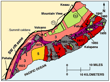
English: Hazard zones for lava flows on Kilauea. The flows erupted since 1800 are shown in gray and dated. Twenty-eight percent of the area encompassed by Zones 1 and 2 on the east half of the volcano has been covered by lava since 1955. The major housing subdivisions on the slopes of the volcano are shown in green. |
| Date | |
| Source | http://pubs.usgs.gov/gip/hazards/kilauea.html |
| Auteur | USGS |
This is the work of the US Government and is in the public domain.
Conditions d’utilisation[modifier]
Cette image est placée dans le domaine public parce qu'elle contient des éléments issus de l'United States Geological Survey, une agence du Département de l'Intérieur des États-Unis. Pour plus d'information, consultez la politique officielle de copyright de l'USGS (en anglais)
|
Historique du fichier
Cliquer sur une date et heure pour voir le fichier tel qu'il était à ce moment-là.
| Date et heure | Vignette | Dimensions | Utilisateur | Commentaire | |
|---|---|---|---|---|---|
| actuel | 27 mai 2010 à 10:08 | | 359 × 270 (18 kio) | Infanalyst (d | contributions) | {{Information |Description={{en|1=Hazard zones for lava flows on Kilauea. The flows erupted since 1800 are shown in gray and dated. Twenty-eight percent of the area encompassed by Zones 1 and 2 on the east half of the volcano has been covered by lava sinc |
Vous ne pouvez pas remplacer ce fichier.
Utilisations locales du fichier
La page suivante utilise ce fichier :
Utilisations du fichier sur d’autres wikis
Les autres wikis suivants utilisent ce fichier :
- Utilisation sur ca.wikipedia.org
- Utilisation sur en.wikipedia.org
- Utilisation sur fr.wikipedia.org