File:King 1950-10-18 weather map.jpg
Jump to navigation
Jump to search

Size of this preview: 800 × 569 pixels. Other resolutions: 320 × 228 pixels | 640 × 455 pixels | 1,024 × 729 pixels | 1,130 × 804 pixels.
Original file (1,130 × 804 pixels, file size: 789 KB, MIME type: image/jpeg)
Captions
Captions
Add a one-line explanation of what this file represents
Summary
| Description | ||||
| Date | ||||
| Source | NOAA Central Library Data Imaging Project | |||
| Author | NOAA Central Library, Silver Spring, Maryland | |||
| Permission (Reusing this file) |
|
File history
Click on a date/time to view the file as it appeared at that time.
| Date/Time | Thumbnail | Dimensions | User | Comment | |
|---|---|---|---|---|---|
| current | 14:30, 21 June 2010 | | 1,130 × 804 (789 KB) | Vyznev Xnebara (talk | contribs) | convert from BMP to JPEG format (with quality 100) |
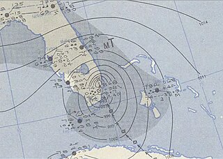
| 00:22, 21 September 2009 |  | 1,130 × 804 (2.6 MB) | Iune (talk | contribs) | {{Information |Description={{en|1=Hurricane King of 1950 near landfall near Miami, Florida.}} |Source=http://docs.lib.noaa.gov/rescue/dwm/data_rescue_daily_weather_maps.html |Author=NOAA |Date=1950 |Permission= |other_versions= }} [[Category:1950 Atlant |
You cannot overwrite this file.
File usage on Commons
The following 2 pages use this file:
- User:Iune/gallery
- File:King 1950 Weather Map.jpg (file redirect)
File usage on other wikis
The following other wikis use this file:
- Usage on de.wikipedia.org
- Usage on en.wikipedia.org
- Usage on es.wikipedia.org
- Usage on min.wikipedia.org
- Usage on pt.wikipedia.org
- Usage on www.wikidata.org
- Usage on zh.wikipedia.org