File:King williams war.svg
跳至導覽
跳至搜尋

此 SVG 檔案的 PNG 預覽的大小:638 × 455 像素。 其他解析度:320 × 228 像素 | 640 × 456 像素 | 1,024 × 730 像素 | 1,280 × 913 像素 | 2,560 × 1,826 像素。
原始檔案 (SVG 檔案,表面大小:638 × 455 像素,檔案大小:1.71 MB)
說明
說明
添加單行說明來描述出檔案所代表的內容
| 描述 |
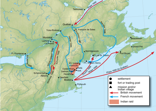
English: Map of King William's War. |
||||
| 日期 | (UTC) | ||||
| 來源 | |||||
| 作者 |
|
||||
| 其他版本 | |||||
| SVG | W3C-validity not checked.
|

授權條款[編輯]
我,本作品的著作權持有者,決定用以下授權條款發佈本作品:

|
已授權您依據自由軟體基金會發行的無固定段落、封面文字和封底文字GNU自由文件授權條款1.2版或任意後續版本,對本檔進行複製、傳播和/或修改。該協議的副本列在GNU自由文件授權條款中。 |
您可以選擇您需要的授權條款。
原始上傳日誌[編輯]
This image is a derivative work of the following images:
- File:New_England_and_South-East_of_Canada_topographic_map-blank.svg licensed with Cc-by-sa-3.0,2.5,2.0,1.0, GFDL
- 2009-08-31T19:35:36Z Sémhur 1455x1040 (540833 Bytes) avec l'image matricielle c'est mieux
- 2009-08-31T19:28:15Z Sémhur 512x366 (297117 Bytes) == {{int:filedesc}} == {{Information |Description= {{en|1=Blank physical map of [[:en:New England|New England]] and south-east of [[:en:Canada|Canada]]}} {{fr|1=Carte physique vierge de la [[:fr:Nouvelle Angleterre|Nouvelle A
Uploaded with derivativeFX
檔案歷史
點選日期/時間以檢視該時間的檔案版本。
| 日期/時間 | 縮圖 | 尺寸 | 用戶 | 備註 | |
|---|---|---|---|---|---|
| 目前 | 2011年5月26日 (四) 20:47 | | 638 × 455(1.71 MB) | Sémhur(對話 | 貢獻) | Bug correction |
| 2011年5月26日 (四) 10:22 |  | 638 × 455(2 MB) | Hoodinski(對話 | 貢獻) | Reverted to version as of 16:32, 25 May 2011 | |
| 2011年5月26日 (四) 10:21 |  | 638 × 455(2.11 MB) | Hoodinski(對話 | 貢獻) | minor | |
| 2011年5月26日 (四) 10:19 |  | 638 × 455(878 KB) | Hoodinski(對話 | 貢獻) | another try at getting rid of the white spaces | |
| 2011年5月25日 (三) 16:32 |  | 638 × 455(2 MB) | Hoodinski(對話 | 貢獻) | Reverted to version as of 12:01, 25 May 2011 | |
| 2011年5月25日 (三) 15:50 |  | 639 × 455(1.63 MB) | Hoodinski(對話 | 貢獻) | minor graphical corrections | |
| 2011年5月25日 (三) 12:01 |  | 638 × 455(2 MB) | Hoodinski(對話 | 貢獻) | margins and white spaces correceted | |
| 2011年5月25日 (三) 11:56 |  | 638 × 455(2.01 MB) | Hoodinski(對話 | 貢獻) | minor | |
| 2011年5月25日 (三) 11:53 |  | 638 × 455(2 MB) | Hoodinski(對話 | 貢獻) | minor | |
| 2011年5月25日 (三) 11:51 |  | 638 × 455(2 MB) | Hoodinski(對話 | 貢獻) | {{Information |Description={{en|Map of King William's War.}} |Source=*File:New_England_and_South-East_of_Canada_topographic_map-blank.svg |Date=2011-05-25 11:50 (UTC) |Author=*File:New_England_and_South-East_of_Canada_topographic_map-blank.svg |
無法覆蓋此檔案。
檔案用途
下列2個頁面有用到此檔案:
全域檔案使用狀況
以下其他 wiki 使用了這個檔案:
- ar.wikipedia.org 的使用狀況
- cs.wikipedia.org 的使用狀況
- de.wikipedia.org 的使用狀況
- en.wikipedia.org 的使用狀況
- es.wikipedia.org 的使用狀況
- fr.wikipedia.org 的使用狀況
- he.wikipedia.org 的使用狀況
- hy.wikipedia.org 的使用狀況
- ja.wikipedia.org 的使用狀況
- nn.wikipedia.org 的使用狀況
- no.wikipedia.org 的使用狀況
- pl.wikipedia.org 的使用狀況
- ru.wikipedia.org 的使用狀況
- uk.wikipedia.org 的使用狀況
- zh.wikipedia.org 的使用狀況