File:Kingdom of Bohemia during the Hussite Wars.jpg
Fitxer original (1.151 × 861 píxels, mida del fitxer: 468 Ko, tipus MIME: image/jpeg)
Llegendes
Llegendes
Resum
[modifica]
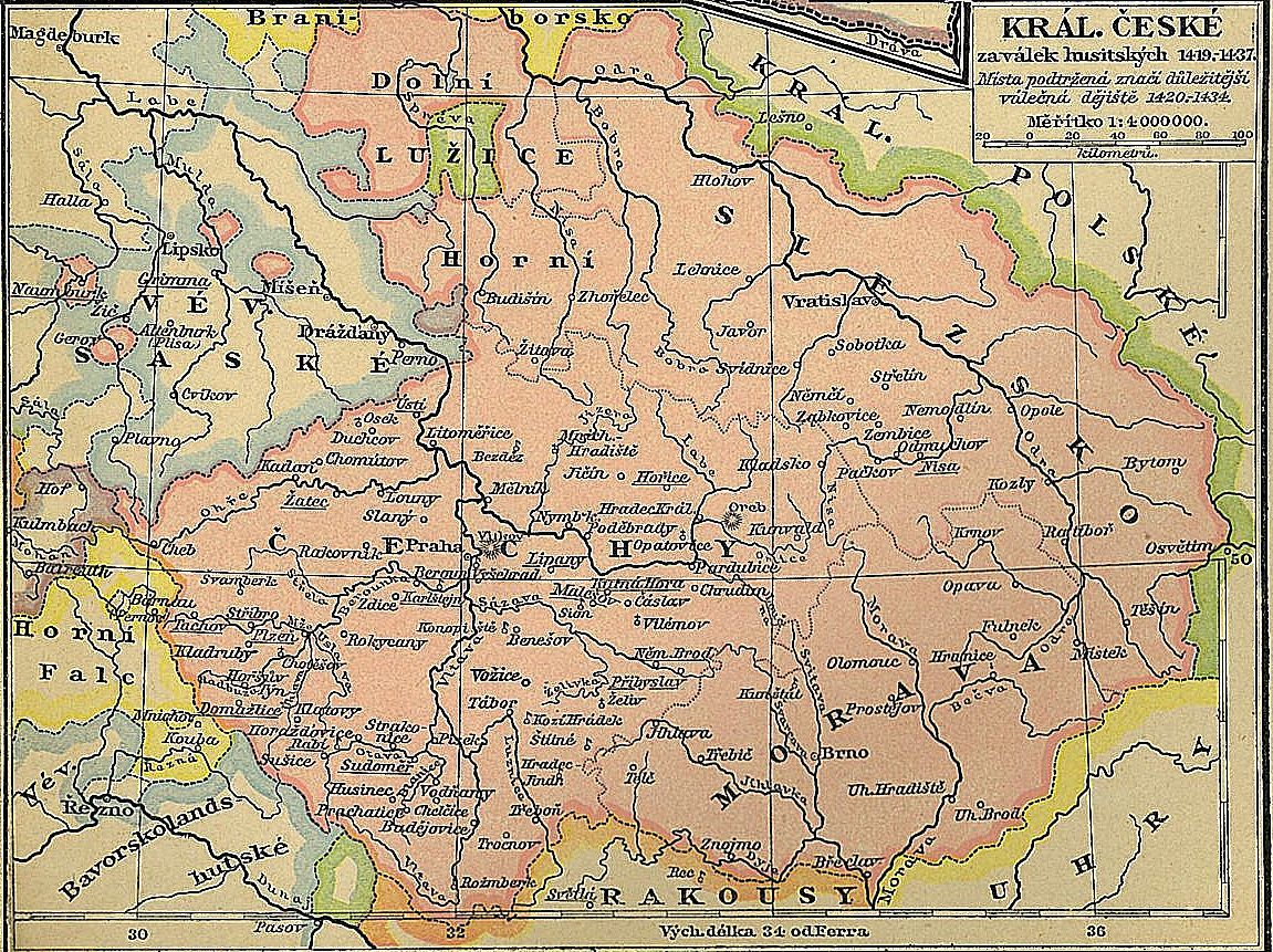
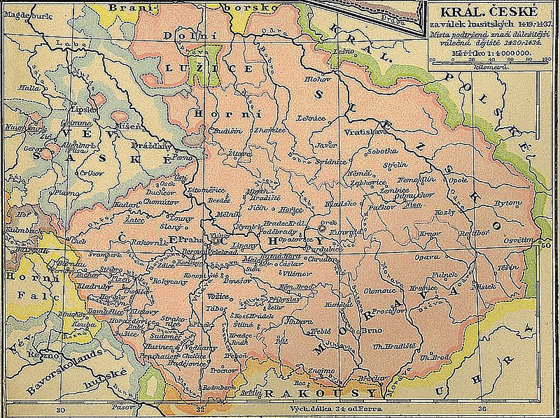
| Descripció | Map of the Kingdom of Bohemia (the area in pink) at the time of the Hussite Wars. The descriptions are in Czech. |
| Data | (unamended reprint of the original first published in 1898) |
| Font | Historický školní atlas by F. W. Putzger, published by the widow and son of A. Pichler in Vienna |
| Autor | Alfred Baldamus, Arnošt Schwab and Vavřinec Josef Dusek |
Llicència
[modifica]
|
Això és una mera fotografia d'una obra d'art bidimensional en domini públic. L'obra d'art original és en domini públic pel següent motiu:
La posició oficial de la Fundació Wikimedia és que «les reproduccions fidels d'obres d'art bidimensionals de domini públic són en domini públic». Per tant, aquesta reproducció fotogràfica també es considera en domini públic als Estats Units. En altres jurisdiccions la reutilització d'aquest contingut pot estar restringida; vegeu Reuse of PD-Art photographs per a més informació. {{PD-Art}} template without license parameter: please specify why the underlying work is public domain in both the source country and the United States
(Usage: {{PD-Art|1=|deathyear=''year of author's death''|country=''source country''}}, where parameter 1= can be PD-old-auto, PD-old-auto-expired, PD-old-auto-1996, PD-old-100 or similar. See Commons:Multi-license copyright tags for more information.) | ||||
Na Zikmundovo naléhání byl proto svolán kostnický koncil, který měl vyřešit problém Na Zikmundovo naléhání byl proto svolán kostnický koncil, který měl vyřešit problém trojpapežství.trojpapežství.
Historial del fitxer
Cliqueu una data/hora per veure el fitxer tal com era aleshores.
| Data/hora | Miniatura | Dimensions | Usuari/a | Comentari | |
|---|---|---|---|---|---|
| actual | 20:29, 26 març 2008 | | 1.151 × 861 (468 Ko) | Geographus (discussió | contribucions) | {{Information |Description= Map of the Kingdom of Bohemia (the area in pink) at the time of the Hussite Wars. The descriptions are in Czech. |Source= Historický školní atlas by F. W. Putzger, published by the widow and son of A. Pichler in Vienna |Dat |
No podeu sobreescriure aquest fitxer.
Ús del fitxer
La pàgina següent utilitza aquest fitxer:
Ús global del fitxer
Utilització d'aquest fitxer en altres wikis:
- Utilització a af.wikipedia.org
- Utilització a an.wikipedia.org
- Utilització a az.wikipedia.org
- Utilització a be.wikipedia.org
- Utilització a ca.wikipedia.org
- Utilització a cs.wikipedia.org
- Utilització a de.wikipedia.org
- Utilització a dsb.wikipedia.org
- Utilització a el.wikipedia.org
- Utilització a en.wikipedia.org
- Utilització a eu.wikipedia.org
- Utilització a fi.wikipedia.org
- Utilització a fr.wikipedia.org
- Utilització a hu.wikipedia.org
- Utilització a hy.wikipedia.org
- Utilització a it.wikipedia.org
- Utilització a ka.wikipedia.org
- Utilització a lv.wikipedia.org
- Utilització a mr.wikipedia.org
- Utilització a pl.wikipedia.org
- Utilització a ps.wikipedia.org
- Utilització a pt.wikipedia.org
- Utilització a ru.wikipedia.org
- Utilització a sk.wikipedia.org
- Utilització a sr.wikipedia.org
- Utilització a uk.wikipedia.org