File:Kingdom of Yugoslavia 1930.svg
跳转到导航
跳转到搜索

此SVG文件的PNG预览的大小:450 × 456像素。 其他分辨率:237 × 240像素 | 474 × 480像素 | 758 × 768像素 | 1,011 × 1,024像素 | 2,021 × 2,048像素。
原始文件 (SVG文件,尺寸为450 × 456像素,文件大小:474 KB)
说明
说明
添加一行文字以描述该文件所表现的内容
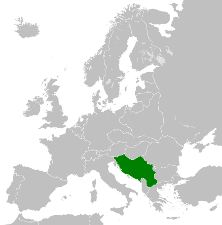
Map of the Kingdom of Yugoslavia in 1930.
| 描述 |
English: Map of the Kingdom of Yugoslavia circa 1930. |
| 日期 | |
| 来源 | Own work, based upon File:Weimar Republic 1930.svg |
| 作者 | |
| 授权 (二次使用本文件) |
本文件采用知识共享署名-相同方式共享 3.0 未本地化版本许可协议授权。
|
| 註解 | 該圖片含有註解:在維基媒體共享資源上查看註解 |
文件历史
点击某个日期/时间查看对应时刻的文件。
| 日期/时间 | 缩略图 | 大小 | 用户 | 备注 | |
|---|---|---|---|---|---|
| 当前 | 2013年8月12日 (一) 08:09 | | 450 × 456(474 KB) | Alphathon(留言 | 贡献) | Fixed Yugoslav-Hungarian border and Dutch polders (see main file) |
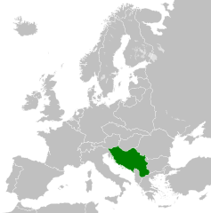
| 2011年12月11日 (日) 19:39 |  | 450 × 456(461 KB) | TRAJAN 117(留言 | 贡献) | {{Information |Description ={{en|1=Map of the Kingdom of Yugoslavia circa 1930.}} |Source =Own work, based upon [http://commons.wikimedia.org/wiki/File:Weimar_Republic_1930.svg] |Author =25px ' |
您不可以覆盖此文件。
文件用途
以下27个页面使用本文件:
- File:LocationKingdomYugoslavia.PNG
- Category:1918 in Yugoslavia
- Category:1919 in Yugoslavia
- Category:1920 in Yugoslavia
- Category:1921 in Yugoslavia
- Category:1922 in Yugoslavia
- Category:1923 in Yugoslavia
- Category:1926 in Yugoslavia
- Category:1927 in Yugoslavia
- Category:1928 in Yugoslavia
- Category:1929 in Yugoslavia
- Category:1930 in Yugoslavia
- Category:1931 in Yugoslavia
- Category:1932 in Yugoslavia
- Category:1933 in Yugoslavia
- Category:1934 in Yugoslavia
- Category:1935 in Yugoslavia
- Category:1936 in Yugoslavia
- Category:1937 in Yugoslavia
- Category:1938 in Yugoslavia
- Category:1939 in Yugoslavia
- Category:1940 in Yugoslavia
- Category:Kingdom of Serbs, Croats and Slovenes
- Category:Kingdom of Yugoslavia
- Category:Yugoslavia in the 1910s
- Category:Yugoslavia in the 1920s
- Category:Yugoslavia in the 1930s
全域文件用途
以下其他wiki使用此文件:
- arz.wikipedia.org上的用途
- ast.wikipedia.org上的用途
- azb.wikipedia.org上的用途
- az.wikipedia.org上的用途
- ba.wikipedia.org上的用途
- bg.wikipedia.org上的用途
- bs.wikipedia.org上的用途
- ca.wikipedia.org上的用途
- cs.wikipedia.org上的用途
- da.wikipedia.org上的用途
- de.wikipedia.org上的用途
- el.wikipedia.org上的用途
- en.wikipedia.org上的用途
- Kingdom of Yugoslavia
- 1st Army (Kingdom of Yugoslavia)
- Creation of Yugoslavia
- 1st Army Group (Kingdom of Yugoslavia)
- 2nd Army Group (Kingdom of Yugoslavia)
- 2nd Army (Kingdom of Yugoslavia)
- 4th Army (Kingdom of Yugoslavia)
- 5th Army (Kingdom of Yugoslavia)
- 7th Army (Kingdom of Yugoslavia)
- 42nd Infantry Division Murska
- 40th Infantry Division Slavonska
- 27th Infantry Division Savska
- 32nd Infantry Division Triglavski
- 1st Cavalry Division (Kingdom of Yugoslavia)
- 38th Infantry Division Dravska
- Germany–Yugoslavia relations
- User:Ditto voltorb/sandbox
- User:Falcaorib/Serbia, Yugoslavia and Albania
- en.wiktionary.org上的用途
- eo.wikipedia.org上的用途
- es.wikipedia.org上的用途
- et.wikipedia.org上的用途
- eu.wikipedia.org上的用途
- fa.wikipedia.org上的用途
- fi.wikipedia.org上的用途
- fr.wikipedia.org上的用途
- gl.wikipedia.org上的用途
- he.wikipedia.org上的用途
- hr.wikipedia.org上的用途
- hu.wikipedia.org上的用途
- hy.wikipedia.org上的用途
- id.wikipedia.org上的用途
- it.wikipedia.org上的用途
查看此文件的更多全域用途。