File:Kingdoms around Israel 830 map.svg
Spring til navigation
Spring til søgning

Size of this PNG preview of this SVG file: 502 × 599 pixels. Andre opløsninger: 201 × 240 pixels | 402 × 480 pixels | 644 × 768 pixels | 858 × 1.024 pixels | 1.717 × 2.048 pixels | 720 × 859 pixels.
Oprindelig fil (SVG fil, basisstørrelse 720 × 859 pixels, filstørrelse: 122 KB)
Captions
Captions
Tilføj en kort forklaring på en enkelt linje om hvad filen viser
| Beskrivelse |
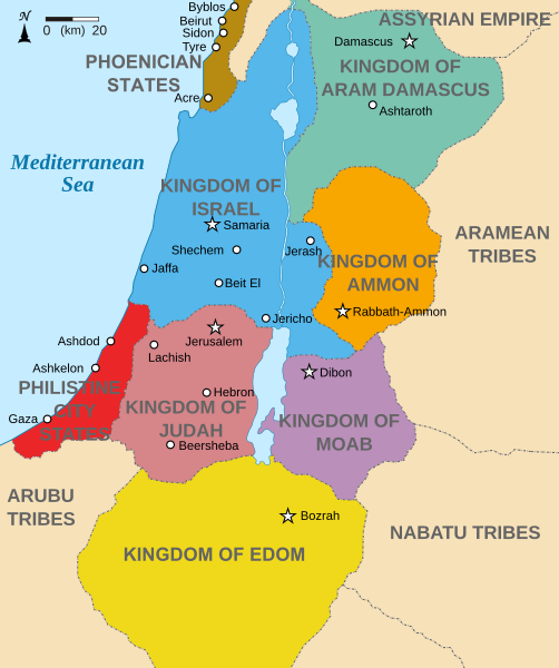
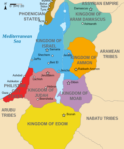
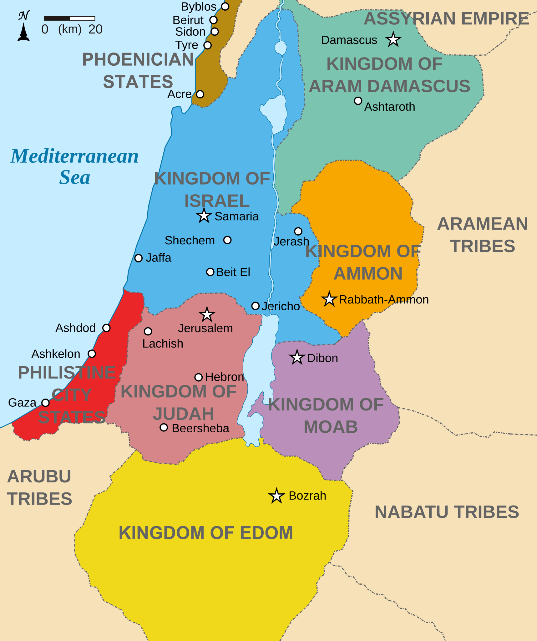
English: Map showing states around Israel & Judah. The Kingdoms around Israel & Judah are colored:
|
| Dato | (UTC) |
| Kilde | |
| Forfatter |
|
| Andre versioner |
[]
|


Jeg, dette værks ophavsretsindehaver, udgiver hermed værket under den følgende licens:
Denne fil er udgivet under Creative Commons Kreditering-Del på samme vilkår 3.0 Ikke-porteret-licensen.
- Du må frit:
- at dele – at kopiere, distribuere og overføre værket
- at remixe – at tilpasse værket
- Under følgende vilkår:
- kreditering – Du skal give passende kreditering, angive et link til licensen, og oplyse om der er foretaget ændringer. Du må gøre det på enhver fornuftig måde, men ikke på en måde der antyder at licensgiveren godkender dig eller din anvendelse.
- deling på samme vilkår – Hvis du bearbejder, ændrer eller bygger videre på dette værk, skal du distribuere dine bidrag under den samme eller en kompatibel licens som originalen.

|
Tilladelse er givet til at kopiere, distribuere og/eller ændre dette dokument under betingelserne i GNU Free Documentation License', Version 1.2 eller enhver senere version udgivet af Free Software Foundation; uden et invariant afsnit, ingen forsidetekster, og ingen bagsidetekst. En kopi af licensen er inkluderet i afsnittet GNU Free Documentation License. |
Du kan vælge den licens du foretrækker.
Oprindelig oplægningslog[redigér]
This image is a derivative work of the following images:
- File:Kingdoms_of_Israel_and_Judah_map_830.svg licensed with Cc-by-sa-3.0, GFDL
- 2010-07-13T10:51:49Z Richardprins 720x859 (80858 Bytes) Added colors for the two kingdoms and converted their text to path and arial
- 2010-07-12T23:53:35Z Richardprins 720x859 (63843 Bytes) Shrinked down the borders
- 2010-07-12T19:43:31Z Richardprins 720x859 (63800 Bytes) {{Information |Description={{en|1=Map showing the ancient levant borders and ancient cities such as [[Urmomium]] and [[Jerash]]. The map also shows the region in the 9th century BCE. Notice the coastal land of Philistia, from
Uploaded with derivativeFX
Filhistorik
Klik på en dato/tid for at se filen som den så ud på det tidspunkt.
| Dato/tid | Miniaturebillede | Dimensioner | Bruger | Kommentar | |
|---|---|---|---|---|---|
| nuværende | 29. okt. 2022, 15:32 | | 720 × 859 (122 KB) | Muchado (diskussion | bidrag) | Fixing font problems (hopefully) |
| 29. okt. 2022, 15:11 |  | 720 × 859 (283 KB) | Muchado (diskussion | bidrag) | Added "Philistine City States" which was unintentionally missed off... | |
| 29. okt. 2022, 15:06 |  | 720 × 859 (239 KB) | Muchado (diskussion | bidrag) | Coloured states, removed anachronistic Petra, added Bozrah, removed Urmomium (Your mom...!), edited Arabu to Arubu, edited to Philistine City States | |
| 10. feb. 2017, 15:51 |  | 720 × 859 (167 KB) | Malus Catulus (diskussion | bidrag) | Removed 'Sizu' - a weird artifact from the Norse original | |
| 13. jul. 2010, 12:58 |  | 720 × 859 (165 KB) | Malus Catulus (diskussion | bidrag) | livened up the colors, converted med sea text to path | |
| 13. jul. 2010, 11:26 |  | 720 × 859 (139 KB) | Malus Catulus (diskussion | bidrag) | {{Information |Description={{en|1=Map showing the ancient levant borders and ancient cities such as Urmomium and Jerash. The Kingdoms around Israel and Judah are colored. The map also shows the region in the 9th century BCE. Notice the coastal lan |
Du kan ikke overskrive denne fil.
Filanvendelse
De følgende 42 sider bruger denne fil:
- User:Ahm masum/test3
- User:Geagea/Israel/2017 February 10
- User:Malus Catulus
- File:Amón 830-es.svg
- File:Edom 830-es.svg
- File:Israel and Judah.png
- File:Kingdom of Ammon 830 map-pt.svg
- File:Kingdom of Damascus 830 map-pt.svg
- File:Kingdom of Edom 830 map-pt.svg
- File:Kingdom of Moab 830 map-pt.svg
- File:Kingdom of Philistines 830 map-es.svg
- File:Kingdom of Philistines 830 map-pt.svg
- File:Kingdoms around Israel 830 map-el.svg
- File:Kingdoms around Israel 830 map-nl.svg
- File:Kingdoms around Israel 830 map-pt.svg
- File:Kingdoms around Israel 830 map.svg
- File:Kingdoms around Israel 830 map mk.svg
- File:Kingdoms around Israel 830 map sh.svg
- File:Kingdoms around Israel 830 map sr.svg
- File:Kingdoms of Israel and Judah map 830-ar.svg
- File:Kingdoms of Israel and Judah map 830-el.svg
- File:Kingdoms of Israel and Judah map 830-es.svg
- File:Kingdoms of Israel and Judah map 830-hu.svg
- File:Kingdoms of Israel and Judah map 830-id.svg
- File:Kingdoms of Israel and Judah map 830-nl.svg
- File:Kingdoms of Israel and Judah map 830-pt.svg
- File:Kingdoms of Israel and Judah map 830.svg
- File:Kingdoms of Israel and Judah map 830 zh.svg
- File:Kingdoms of the Levant Map 830.xcf
- File:Levant 830-HE-2.svg
- File:Levant 830-HE.svg
- File:Levant 830-rus.svg
- File:Levant 830.svg
- File:Levant 830 map-pt.svg
- File:Levant hu.svg
- File:Levante 830-es.svg
- File:Moab 830-es.svg
- File:Philistine language.svg
- File:Royaumes autour d'Israel en 830.svg
- File:イスラエル王国とユダ王国.svg
- Template:Other versions/Kingdoms around Israel 830 map
- Category:Ammon
Global filanvendelse
Følgende andre wikier anvender denne fil:
- Anvendelser på af.wikipedia.org
- Anvendelser på arc.wikipedia.org
- Anvendelser på ar.wikipedia.org
- Anvendelser på arz.wikipedia.org
- Anvendelser på azb.wikipedia.org
- Anvendelser på bg.wikipedia.org
- Anvendelser på bn.wikipedia.org
- Anvendelser på br.wikipedia.org
- Anvendelser på ca.wikipedia.org
- Anvendelser på cs.wikipedia.org
- Anvendelser på da.wikipedia.org
- Anvendelser på en.wikipedia.org
- Ammon
- History of the ancient Levant
- Kingdom of Judah
- Kingdom of Israel (Samaria)
- Philistines
- Moab
- Philistia
- Talk:Phoenician language
- Aram-Damascus
- Edom
- Portal:Bible/Featured chapter/Psalms
- Portal:Bible/Featured chapter/Psalms 83
- User:Kazkaskazkasako/Books/History
- Transjordan (region)
- Ezekiel 25
- User:Jacksonmcdonald3425/sandbox
- User:Falcaorib/Ancient Empires (3500-550 BC)
- Anvendelser på en.wiktionary.org
- Anvendelser på eo.wikipedia.org
- Anvendelser på et.wikipedia.org
Vis flere globale anvendelser af denne fil.