File:Kingdoms around Israel 830 map.svg
Pumunta sa nabigasyon
Pumunta sa paghahanap

Size of this PNG preview of this SVG file: 502 x 599 na pixel. Ibang mga resolusyon: 201 x 240 na pixel | 402 x 480 na pixel | 644 x 768 na pixel | 858 x 1,024 na pixel | 1,717 x 2,048 na pixel | 720 x 859 na pixel.
Orihinal na file (SVG na file, nominal na 720 × 859 (na) pixel, laki: 122 KB)
Captions
Captions
Add a one-line explanation of what this file represents
| Paglalarawan |
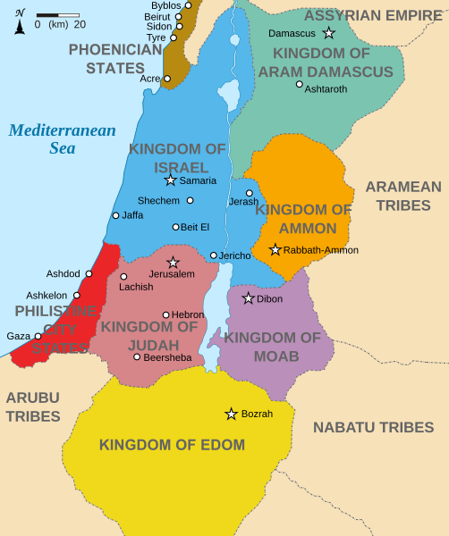
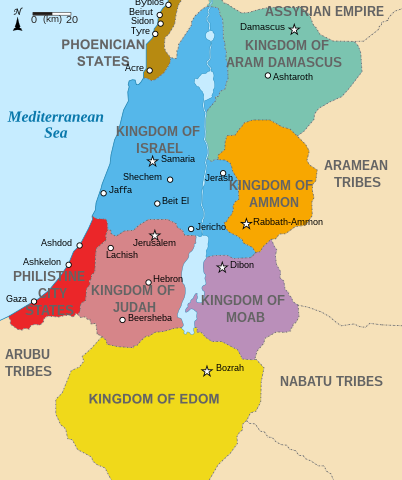
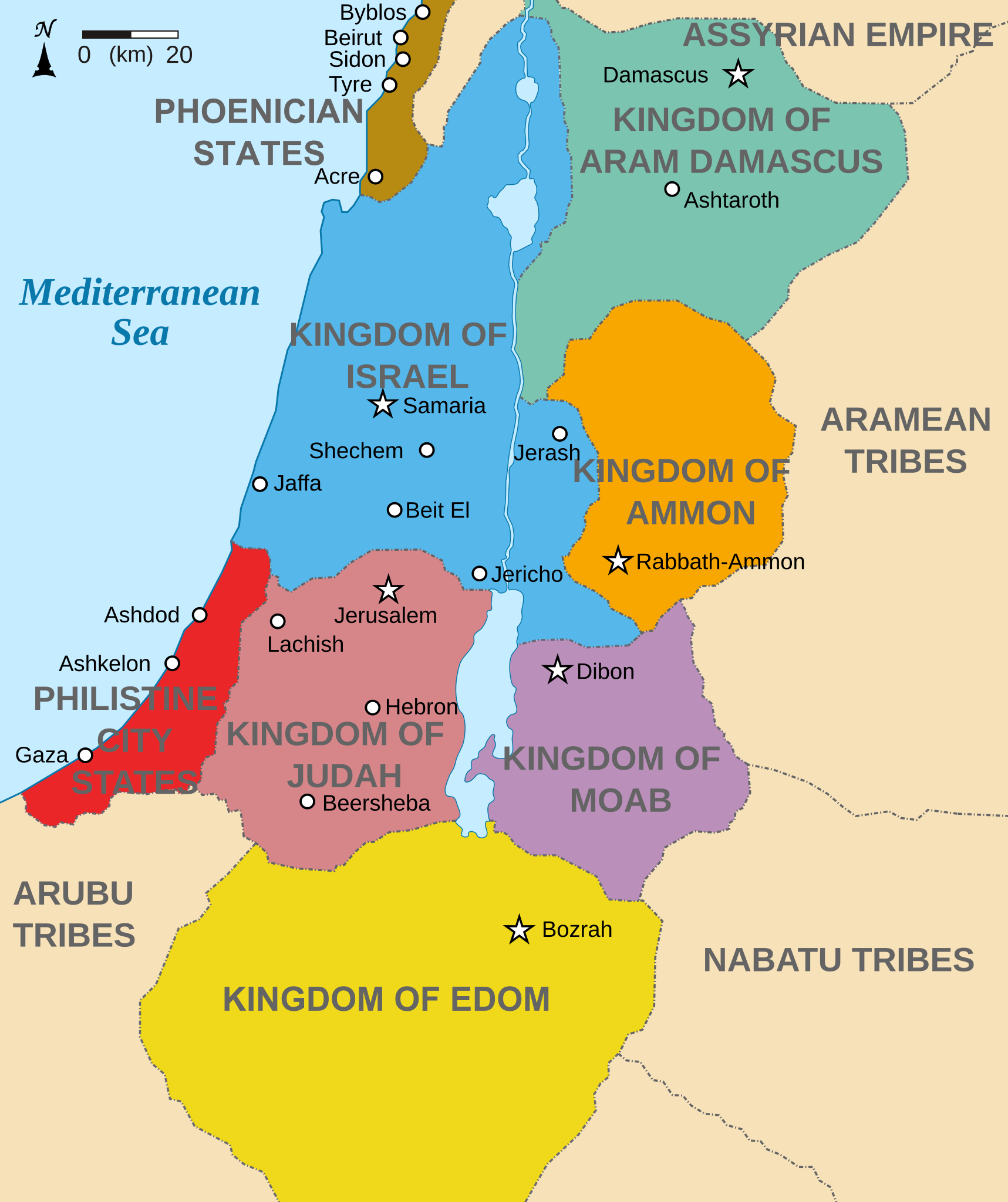
English: Map showing states around Israel & Judah. The Kingdoms around Israel & Judah are colored:
|
| Petsa | (UTC) |
| Pinanggalingan | |
| May-akda |
|
| Iba pang mga bersyon |
[]
|


Ako, na may karapatang-ari ng akdang ito, ang naglalathala nito alinsunod sa ilalim ng sumusunod na mga lisensya:
Lisensyado ang file na ito sa ilalim ng lisensiyang Creative Commons Attribution-Share Alike 3.0 Unported.
- Malaya kang:
- para ibahagi – para kopyahin, ipamahagi, at i-transmit ang akda
- para i-remix – para i-adapt ang akda
- Sa ilalim ng mga kondisyong ito:
- atribusyon – Dapat magbigay ka ng isang maayos na pag-credit, ibigay ang link sa lisensiya, at tukuyin kung may mga pagbabagong ginawa. Magagawa mo ito sa isang risonableng paraan, pero hindi sa paraan na para bang ineendorso ka o ng paggamit mo ng naglisensiya sa'yo.
- share alike – Kung ire-remix mo, babaguhin, o magdadagdag ka sa materyal, dapat mong ipamahagi ang mga ambag mo sa ilalim ng pareho o katulad na lisensiya.

|
Pinapayagan ang pagkopya, pamamahagi, at/o pagbabago sa dokumentong ito sa ilalim ng mga nakasaad sa GNU Free Documentation License, Bersyon 1.2 o kahit anong mas bagong bersyong nilathala ng Free Software Foundation; nang walang pabago-bagong bahagi, walang teksto sa front-cover, at walang teksto sa back-cover. May nakalagay na kopya ng lisensiya sa bahaging pinamagatang GNU Free Documentation License. |
Makakapili ka ng lisensiyang gusto mo.
Tala ng orihinal na pagkarga[baguhin]
This image is a derivative work of the following images:
- File:Kingdoms_of_Israel_and_Judah_map_830.svg licensed with Cc-by-sa-3.0, GFDL
- 2010-07-13T10:51:49Z Richardprins 720x859 (80858 Bytes) Added colors for the two kingdoms and converted their text to path and arial
- 2010-07-12T23:53:35Z Richardprins 720x859 (63843 Bytes) Shrinked down the borders
- 2010-07-12T19:43:31Z Richardprins 720x859 (63800 Bytes) {{Information |Description={{en|1=Map showing the ancient levant borders and ancient cities such as [[Urmomium]] and [[Jerash]]. The map also shows the region in the 9th century BCE. Notice the coastal land of Philistia, from
Uploaded with derivativeFX
Nakaraan ng file
Pindutin ang isang petsa/oras para makita ang file noong puntong yon.
| Petsa/Oras | Thumbnail | Sukat | Tagagamit | Komento | |
|---|---|---|---|---|---|
| ngayon | 15:32, 29 Oktubre 2022 | | 720 × 859 (122 KB) | Muchado (usapan | ambag) | Fixing font problems (hopefully) |
| 15:11, 29 Oktubre 2022 |  | 720 × 859 (283 KB) | Muchado (usapan | ambag) | Added "Philistine City States" which was unintentionally missed off... | |
| 15:06, 29 Oktubre 2022 |  | 720 × 859 (239 KB) | Muchado (usapan | ambag) | Coloured states, removed anachronistic Petra, added Bozrah, removed Urmomium (Your mom...!), edited Arabu to Arubu, edited to Philistine City States | |
| 15:51, 10 Pebrero 2017 |  | 720 × 859 (167 KB) | Malus Catulus (usapan | ambag) | Removed 'Sizu' - a weird artifact from the Norse original | |
| 12:58, 13 Hulyo 2010 |  | 720 × 859 (165 KB) | Malus Catulus (usapan | ambag) | livened up the colors, converted med sea text to path | |
| 11:26, 13 Hulyo 2010 |  | 720 × 859 (139 KB) | Malus Catulus (usapan | ambag) | {{Information |Description={{en|1=Map showing the ancient levant borders and ancient cities such as Urmomium and Jerash. The Kingdoms around Israel and Judah are colored. The map also shows the region in the 9th century BCE. Notice the coastal lan |
Hindi mo mao-overwrite ang file na ito.
Paggamit sa file
Ginagamit ng sumusunod na pahina ang file na ito:
- User:Ahm masum/test3
- User:Geagea/Israel/2017 February 10
- User:Malus Catulus
- File:Amón 830-es.svg
- File:Edom 830-es.svg
- File:Israel and Judah.png
- File:Kingdom of Ammon 830 map-pt.svg
- File:Kingdom of Damascus 830 map-pt.svg
- File:Kingdom of Edom 830 map-pt.svg
- File:Kingdom of Moab 830 map-pt.svg
- File:Kingdom of Philistines 830 map-es.svg
- File:Kingdom of Philistines 830 map-pt.svg
- File:Kingdoms around Israel 830 map-el.svg
- File:Kingdoms around Israel 830 map-nl.svg
- File:Kingdoms around Israel 830 map-pt.svg
- File:Kingdoms around Israel 830 map.svg
- File:Kingdoms around Israel 830 map mk.svg
- File:Kingdoms around Israel 830 map sh.svg
- File:Kingdoms around Israel 830 map sr.svg
- File:Kingdoms of Israel and Judah map 830-ar.svg
- File:Kingdoms of Israel and Judah map 830-el.svg
- File:Kingdoms of Israel and Judah map 830-es.svg
- File:Kingdoms of Israel and Judah map 830-hu.svg
- File:Kingdoms of Israel and Judah map 830-id.svg
- File:Kingdoms of Israel and Judah map 830-nl.svg
- File:Kingdoms of Israel and Judah map 830-pt.svg
- File:Kingdoms of Israel and Judah map 830.svg
- File:Kingdoms of Israel and Judah map 830 zh.svg
- File:Kingdoms of the Levant Map 830.xcf
- File:Levant 830-HE-2.svg
- File:Levant 830-HE.svg
- File:Levant 830-rus.svg
- File:Levant 830.svg
- File:Levant 830 map-pt.svg
- File:Levant hu.svg
- File:Levante 830-es.svg
- File:Moab 830-es.svg
- File:Philistine language.svg
- File:Royaumes autour d'Israel en 830.svg
- File:イスラエル王国とユダ王国.svg
- Template:Other versions/Kingdoms around Israel 830 map
- Category:Ammon
Pandaigdigang paggamit sa file
Ginagamit ng mga sumusunod na wiki ang file na ito:
- Paggamit sa af.wikipedia.org
- Paggamit sa arc.wikipedia.org
- Paggamit sa ar.wikipedia.org
- Paggamit sa arz.wikipedia.org
- Paggamit sa azb.wikipedia.org
- Paggamit sa bg.wikipedia.org
- Paggamit sa bn.wikipedia.org
- Paggamit sa br.wikipedia.org
- Paggamit sa ca.wikipedia.org
- Paggamit sa cs.wikipedia.org
- Paggamit sa da.wikipedia.org
- Paggamit sa en.wikipedia.org
- Ammon
- History of the ancient Levant
- Kingdom of Judah
- Kingdom of Israel (Samaria)
- Philistines
- Moab
- Philistia
- Talk:Phoenician language
- Aram-Damascus
- Edom
- Portal:Bible/Featured chapter/Psalms
- Portal:Bible/Featured chapter/Psalms 83
- User:Kazkaskazkasako/Books/History
- Transjordan (region)
- Ezekiel 25
- User:Falcaorib
- User:Jacksonmcdonald3425/sandbox
- Paggamit sa en.wiktionary.org
- Paggamit sa eo.wikipedia.org
- Paggamit sa et.wikipedia.org
- Paggamit sa eu.wikipedia.org
Tingnan ang karagdagang pandaigdigang paggamit sa file na ito.