File:Kingdoms of Israel and Judah map 830.svg
Us Wikimedia Commons
Zur Navigation springen
Zur Suche springen

Gröössi vor PNG-Vorschou vor SVG-Datei: 502 × 599 Pixel. Wyteri Ufflösige: 201 × 240 Pixel | 402 × 480 Pixel | 644 × 768 Pixel | 858 × 1.024 Pixel | 1.717 × 2.048 Pixel | 720 × 859 Pixel.
Originaldatei (SVG-Datei, Basisgrößi: 720 × 859 Pixel, Dateigrößi: 96 KB)
Dateiinformationen
Strukturierte Daten
Bildtexte
Kurzbeschreibungen
Ergänze eine einzeilige Erklärung, was diese Datei darstellt.
പുരാതന യിസ്രായേൽ-യഹൂദ രാജ്യങ്ങൾ
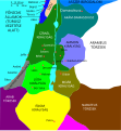
Isroil (koʻk rangda) va Yahudo (toʻq sariq rangda) qirolliklari, qadimgi Janubiy Levant chegaralari va Urmomium va Jerash kabi qadimiy shaharlarni koʻrsatadigan taxminiy xarita. Xaritada mintaqa miloddan avvalgi 9-asrda koʻrsatilgan.
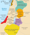
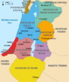
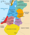
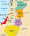
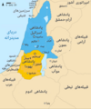
Approximate map showinhjjjg the Kingdoms of Israel (blue) and Judah (orange), ancient Southern Levant borders and ancient cities. The map shows the region in the 9th century BCE.
| BschryybigKingdoms of Israel and Judah map 830.svg |
English: Approximate map showing the Kingdoms of Israel (blue) and Judah (orange), ancient Southern Levant borders and ancient cities such as Urmomium and Jerash. The map shows the region in the 9th century BCE. Italiano: Il regno di Giuda e quello di Israele nell'età del ferro (VIII secolo a.C.).
日本語: 紀元前830年代のユダ王国(黄色).
Русский: Царство Иудея 927 по 526 гг. до н. э. Отсюда иудеи были сосланы завоевателями в Вавилонский регион.
Bahasa Indonesia: Peta kerajaan-kerajaan di daerah tersebut pada abad 9 SM.
Simple English: The northern Kingdom of Israel and the Kingdom of Judah to the south.
Srpskohrvatski / српскохрватски: Karta Sjevernog i JUžnog Kraljevstva. Samarija je bila glavni grad Kraljevstva Izrael (plavo). 830-e pne.,.
Latviešu: Izraēlas un Jūdejas karalistes. Jūdejas karaliste (dzeltenā) ap 830. gadu p.m.ē. |
| Datum | (UTC) |
| Quälle | http://www.jewishvirtuallibrary.org/map-of-israel-and-judah-733-bce |
| Urheber |
|
| Anderi Versione |
[ändere]
|
Ich haa s Urheberrächt an däm Wärch un vereffetlig s dodermit unter däne Lizänze:
Die Datei isch lizänziert unter dr Creative-Commons-Lizenz Namensnännig – Wytergab unter glyche Bedingige 3.0 nit portiert.
- Du derfsch:
- des Wärch an anderi wytergee – des Wärch kopiere, verbreite un ibertrage
- des Wärch verändere – des Wärch aapasse
- Unter däne Bedingige:
- Namenännig – Du muesch aagmässeni Aagabe zum Urheber un dr Rächt mache, e Link zue dr Lizänz zuefiege un aagee, eb Änderige gmacht wore sin. Die Aagabe chenne in ere aagmässene Art gmacht wäre, aber nit eso, ass dr Yydruck entstoht, ass dr Lizänzgeber Dii oder Dyy Gebruch vum Wärch unterstitze un guetheiße.
- Wytergab unter glyche Bedingige – Wänn du des Wärch veränderesch, umwandlesch oder druf ufböusch, no derfsch s Ergebnis nume unter dr glyche oder ere kumpatible Lizänz wie s Orginal vereffetlige.

|
Des Dokumänt derf kopiert, verbreitet un/oder bearbeitet wäre unter dr Bedingige vu dr GNU-Lizänz fir freji Dokumäntation, Version 1.2 oder ere spetere Version, vereffetligt dur Free Software Foundation. S het keini uuveränderlige Abschnitt, kei vordere Umschlagstext un kei hindere Umschlagstext. E Kopii vu dr Lizänz isch verfiegbar im Abschnitt GNU-Lizänz fir freji Dokumäntation.http://www.gnu.org/copyleft/fdl.htmlGFDLGNU Free Documentation Licensetruetrue |
Du chasch sälber e Lizänz uuswehle.
Orginal Logbuech vu uffegladene Datei[ändere]
This image is a derivative work of the following images:
- File:Oldtidens_Israel_&_Judea.svg licensed with Cc-by-sa-3.0, GFDL
- 2010-01-30T16:10:36Z FinnWikiNo 726x868 (109641 Bytes) {{Information |Description={{en|1=Map showing the ancient levant borders and ancient cities such as [[Urmomium]] and [[Jerash]]. The map also shows the region in the 9th century BCE. Notice the coastal land of Philistia, from
Uploaded with derivativeFX
Dateiversione
Klick uf e Zytpunkt zu aazeige, wie s dert usgsäh het.
| Version vom | Vorschaubild | Mäß | Benutzer | Kommentar | |
|---|---|---|---|---|---|
| aktuell | 14:12, 1. Okt. 2021 |  | 720 × 859 (96 KB) | Sadopaul (Diskussion | Byträg) | File uploaded using svgtranslate tool (https://svgtranslate.toolforge.org/). Added translation for ko. |
| 15:50, 10. Feb. 2017 |  | 720 × 859 (80 KB) | Malus Catulus (Diskussion | Byträg) | removed 'Sizu' - a weird artifact from the Norse original | |
| 23:48, 12. Feb. 2011 |  | 720 × 859 (78 KB) | Malus Catulus (Diskussion | Byträg) | - | |
| 11:29, 13. Jul. 2010 | 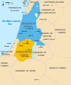 | 720 × 859 (79 KB) | Malus Catulus (Diskussion | Byträg) | Fixed Judah color | |
| 10:51, 13. Jul. 2010 |  | 720 × 859 (79 KB) | Malus Catulus (Diskussion | Byträg) | Added colors for the two kingdoms and converted their text to path and arial | |
| 23:53, 12. Jul. 2010 |  | 720 × 859 (62 KB) | Malus Catulus (Diskussion | Byträg) | Shrinked down the borders | |
| 19:43, 12. Jul. 2010 |  | 720 × 859 (62 KB) | Malus Catulus (Diskussion | Byträg) | {{Information |Description={{en|1=Map showing the ancient levant borders and ancient cities such as Urmomium and Jerash. The map also shows the region in the 9th century BCE. Notice the coastal land of Philistia, from which the name "Palestine |
Du chasch die Datei nit iberschryybe.
Verwändig vu dr Datei
Die 38 Syte bruuche die Datei:
- Jewish history
- User:Geagea/Israel/2017 February 10
- User:Malus Catulus
- File:Amón 830-es.svg
- File:Edom 830-es.svg
- File:Israel and Judah.png
- File:Kingdoms around Israel 830 map-el.svg
- File:Kingdoms around Israel 830 map-nl.svg
- File:Kingdoms around Israel 830 map-pt.svg
- File:Kingdoms around Israel 830 map.svg
- File:Kingdoms around Israel 830 map mk.svg
- File:Kingdoms around Israel 830 map sh.svg
- File:Kingdoms around Israel 830 map sr.svg
- File:Kingdoms of Israel and Judah map 830-ar.svg
- File:Kingdoms of Israel and Judah map 830-el.svg
- File:Kingdoms of Israel and Judah map 830-es.svg
- File:Kingdoms of Israel and Judah map 830-hu.svg
- File:Kingdoms of Israel and Judah map 830-id.svg
- File:Kingdoms of Israel and Judah map 830-nl.svg
- File:Kingdoms of Israel and Judah map 830-pt.svg
- File:Kingdoms of Israel and Judah map 830.svg
- File:Kingdoms of Israel and Judah map 830 zh.svg
- File:Kingdoms of the Levant Map 830.xcf
- File:Levant 01.PNG
- File:Levant 830-HE-2.svg
- File:Levant 830-HE.svg
- File:Levant 830-rus.svg
- File:Levant 830.svg
- File:Levant 830 map-pt.svg
- File:Levant hu.svg
- File:Levante 830-es.svg
- File:Moab 830-es.svg
- File:Royaumes autour d'Israel en 830.svg
- File:イスラエル王国とユダ王国.svg
- Template:Other versions/Kingdoms around Israel 830 map
- Template:Other versions/Kingdoms of Israel and Juda map 830
- Category:Kingdom of Israel
- Category:Kingdom of Judah
Wältwyti Dateinutzig
Die andere Wikis bruche die Datei:
- Gebruch uf af.wikipedia.org
- Gebruch uf als.wikipedia.org
- Gebruch uf arz.wikipedia.org
- Gebruch uf azb.wikipedia.org
- Gebruch uf az.wikipedia.org
- Gebruch uf bar.wikipedia.org
- Gebruch uf be-tarask.wikipedia.org
- Gebruch uf be.wikipedia.org
- Gebruch uf bg.wikipedia.org
- Gebruch uf bn.wikipedia.org
- Gebruch uf br.wikipedia.org
- Gebruch uf bs.wikipedia.org
- Gebruch uf bxr.wikipedia.org
- Gebruch uf ca.wikipedia.org
- Gebruch uf cdo.wikipedia.org
- Gebruch uf cs.wikipedia.org
- Gebruch uf da.wikipedia.org
- Gebruch uf de.wikipedia.org
- Gebruch uf de.wikibooks.org
- Gebruch uf en.wikipedia.org
Wältwyti Verwändig vu däre Datei aaluege.
Metadate
Die Datei het wyteri Informatione, allwäg vor Digitalkamera oder vom Scanner wo se het gschaffe.
We die Datei isch veränderet worde, de cha's sy, das die zuesätzlechi Information für di verändereti Datei nümm richtig zuetrifft.
| Breiti | 719.58716 |
|---|---|
| Längi | 858.64001 |

