File:Kiowa map.jpg
Jump to navigation
Jump to search
No higher resolution available.
Kiowa_map.jpg (615 × 453 pixels, file size: 102 KB, MIME type: image/jpeg)
Captions
Captions
Add a one-line explanation of what this file represents
Summary
[edit]
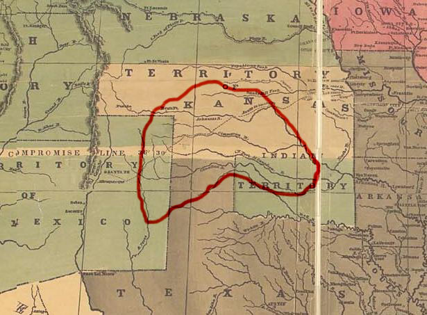
| Description | Map showing approximately the area occupied by the Kiowa tribe prior to 1850. It's made using "Reynolds's Political Map of the United States" (1856) from Library of Congress collection (public domain). |
| Date | 26 September 2006 (original upload date) |
| Source | No machine-readable source provided. Own work assumed (based on copyright claims). |
| Author | No machine-readable author provided. Left Hook~commonswiki assumed (based on copyright claims). |
Licensing
[edit]
| I, the copyright holder of this work, release this work into the public domain. This applies worldwide. In some countries this may not be legally possible; if so: I grant anyone the right to use this work for any purpose, without any conditions, unless such conditions are required by law. |
File history
Click on a date/time to view the file as it appeared at that time.
| Date/Time | Thumbnail | Dimensions | User | Comment | |
|---|---|---|---|---|---|
| current | 16:23, 26 September 2006 | | 615 × 453 (102 KB) | Left Hook~commonswiki (talk | contribs) | Map showing approximately the area occupied by the Kiowa tribe prior to 1850. It's made using "Reynolds's Political Map of the United States" (1856) from Library of Congress collection (public domain). |
You cannot overwrite this file.
File usage on Commons
There are no pages that use this file.
File usage on other wikis
The following other wikis use this file:
- Usage on ca.wikipedia.org
- Usage on da.wikipedia.org
- Usage on en.wikipedia.org
- Usage on no.wikipedia.org
- Usage on ru.wikipedia.org
- Usage on sr.wikipedia.org
- Usage on sv.wikipedia.org
- Usage on uk.wikipedia.org