File:Kirillov district Names.svg
Jump to navigation
Jump to search

Size of this PNG preview of this SVG file: 319 × 599 pixels. Other resolutions: 128 × 240 pixels | 255 × 480 pixels | 409 × 768 pixels | 545 × 1,024 pixels | 1,090 × 2,048 pixels | 450 × 845 pixels.
Original file (SVG file, nominally 450 × 845 pixels, file size: 44 KB)
Captions
Captions
Add a one-line explanation of what this file represents
| Description |
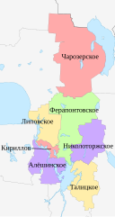
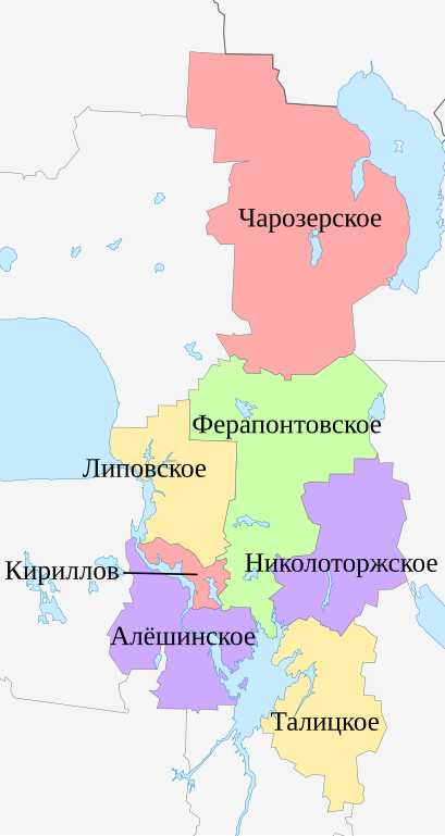
Русский: Схема муниципальных образований Кирилловского района Вологодской области, 2009 год Равноугольная проекция, растяжение — 200 %. Координаты краёв: * север — 60.9° С * юг — 59.4° С * восток — 39.2° В * запад — 37.6° В |
| Date | (UTC) |
| Source | |
| Author |
|
.svg)
| This is a retouched picture, which means that it has been digitally altered from its original version. Modifications: colors and names. The original can be viewed here: Outline Map of Kirillovsky District (Vologda Oblast, 2009).svg:
|
This file is licensed under the Creative Commons Attribution-Share Alike 3.0 Unported license.
- You are free:
- to share – to copy, distribute and transmit the work
- to remix – to adapt the work
- Under the following conditions:
- attribution – You must give appropriate credit, provide a link to the license, and indicate if changes were made. You may do so in any reasonable manner, but not in any way that suggests the licensor endorses you or your use.
- share alike – If you remix, transform, or build upon the material, you must distribute your contributions under the same or compatible license as the original.
Original upload log
[edit]
This image is a derivative work of the following images:
- File:Outline_Map_of_Kirillovsky_District_(Vologda_Oblast,_2009).svg licensed with PD-self
- 2010-08-04T13:40:23Z Виктор В 114x214 (39707 Bytes) == {{int:filedesc}} == {{Information |Description={{ru|1=Позиционная карта Кирилловского района Вологодской области, 2009 годРавноугольная проекция,
Uploaded with derivativeFX
File history
Click on a date/time to view the file as it appeared at that time.
| Date/Time | Thumbnail | Dimensions | User | Comment | |
|---|---|---|---|---|---|
| current | 15:40, 25 July 2021 | | 450 × 845 (44 KB) | Kaidor (talk | contribs) | объединение Ферапонтовского и Коварзинского сельских поселений |
| 08:44, 18 December 2015 |  | 114 × 214 (48 KB) | Dima st bk (talk | contribs) | поселения Горицкое и Кириллов объединены | |
| 16:38, 9 August 2010 |  | 114 × 214 (50 KB) | Daryona (talk | contribs) | {{Information |Description={{ru|1=Схема муниципальных образований Кирилловского района Вологодской области, 2009 год<br>Равноугольная проекция, растяжение |
You cannot overwrite this file.
File usage on Commons
The following page uses this file:
.svg)
File usage on other wikis
The following other wikis use this file:
- Usage on fi.wikipedia.org
- Usage on ru.wikipedia.org