File:Kisakata air.jpg
Jump to navigation
Jump to search

Size of this preview: 601 × 600 pixels. Other resolutions: 241 × 240 pixels | 481 × 480 pixels | 770 × 768 pixels | 1,027 × 1,024 pixels | 2,030 × 2,025 pixels.
Original file (2,030 × 2,025 pixels, file size: 3.28 MB, MIME type: image/jpeg)
Captions
Captions
Add a one-line explanation of what this file represents
Summary
[edit]
| Description |
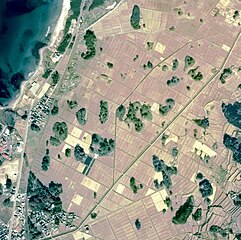
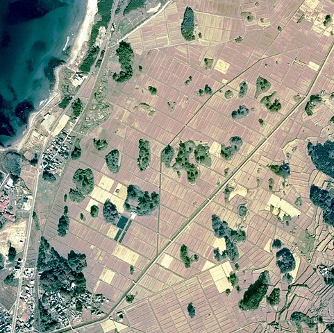
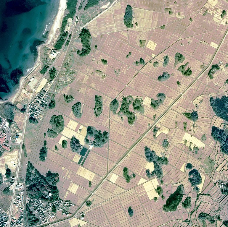
English: Aerial Photo of Kisakata, Nikaho, Akita, Japan. 日本語:秋田県にかほ市象潟の航空写真
日本語:象潟の空中写真。cto-76-9_c9a_3 を使用。 |
| Date | |
| Source | image from (Color Aerial Photo) cto-76-9_c9a_3 ja:ファイル:Cto-76-9 c9a 3 1.jpg |
| Author | Ministry of Land, Infrastructure, Transport and Tourism |
Licensing
[edit]

|
The copyright holder of this file, the Ministry of Land, Infrastructure, Transport and Tourism of Japan, allows anyone to use it for any purpose, provided that the copyright holder is properly attributed. Redistribution, derivative work, commercial use, and all other use is permitted. |
Attribution:
Copyright © National Land Image Information (Color Aerial Photographs), Ministry of Land, Infrastructure, Transport and Tourism
|
 |
This image is copyrighted by the Ministry of Land, Infrastructure, Transport and Tourism of Japan. For terms of use, see the stipulation to use of National Land Information (in Japanese) and message from MLIT (in Japanese and English). When you display this image on an article, include the following phrase in the description: "Made based on National Land Image Information (Color Aerial Photographs), Ministry of Land, Infrastructure, Transport and Tourism".
|
File history
Click on a date/time to view the file as it appeared at that time.
| Date/Time | Thumbnail | Dimensions | User | Comment | |
|---|---|---|---|---|---|
| current | 16:53, 5 December 2011 | | 2,030 × 2,025 (3.28 MB) | トトト (talk | contribs) | tone curve, brightness level adjusted. |
| 13:03, 9 November 2010 |  | 2,030 × 2,025 (707 KB) | Reggaeman (talk | contribs) | {{Information |Description={{en|Aerial Photo of Kisakata, Nikaho, Akita, Japan.}}{{ja|秋田県にかほ市象潟の航空写真}} |Source=image from [http://w3land.mlit.go.jp/WebGIS/ (Color Aerial Photo)] cto-76-9_c9a_3 |Date=1976 |Author=Ministry of Lan | |
| 06:52, 7 September 2010 |  | 2,030 × 2,025 (707 KB) | Takayama Sora (talk | contribs) | {{Information |Description={{ja|1=象潟の空中写真。cto-76-9_c9a_3 を使用。}} |Source=国土情報ウェブマッピングシステム |Author=国土交通省 |Date=1976年 |Permission= |other_versions= }} |
You cannot overwrite this file.
File usage on Commons
The following page uses this file:
File usage on other wikis
The following other wikis use this file:
- Usage on ja.wikipedia.org
- Usage on www.wikidata.org