File:Knowledge of Russian EU map.svg
Aller à la navigation
Aller à la recherche

Taille de cet aperçu PNG pour ce fichier SVG : 587 × 600 pixels. Autres résolutions : 235 × 240 pixels | 470 × 480 pixels | 751 × 768 pixels | 1 002 × 1 024 pixels | 2 004 × 2 048 pixels | 590 × 603 pixels.
Fichier d’origine (Fichier SVG, nominalement de 590 × 603 pixels, taille : 661 kio)
Légendes
Légendes
Ajoutez en une ligne la description de ce que représente ce fichier
Description[modifier]
| Description |
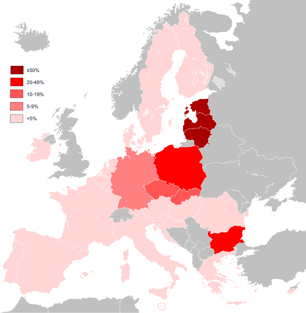
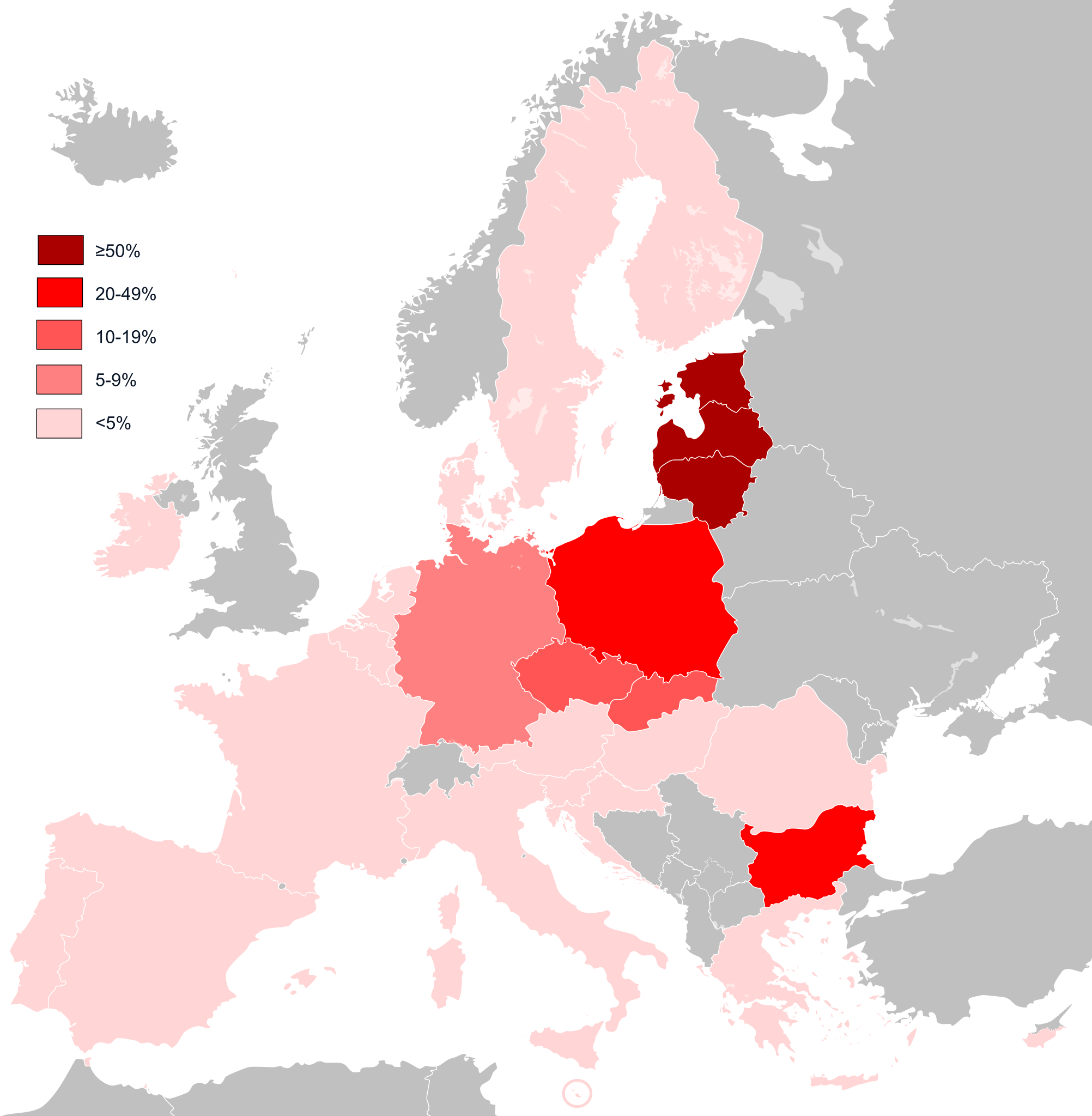
English: Knowledge of Russian EU map.
Français : Connaissance du russe dans l'Union européenne.
Čeština: Znalost ruštiny v zemích Evropské unie.
Русский: Процент владения русским языком среди населения стран-членов ЕС |
| Date | |
| Source | Travail personnel |
| Auteur | Tyk |
| SVG information | Le code de ce fichier SVG n'est pas valide en raison de 2 erreurs. |
Conditions d’utilisation[modifier]
| Moi, propriétaire des droits d’auteur sur cette œuvre, la place dans le domaine public. Ceci s'applique dans le monde entier. Dans certains pays, ceci peut ne pas être possible ; dans ce cas : J’accorde à toute personne le droit d’utiliser cette œuvre dans n’importe quel but, sans aucune condition, sauf celles requises par la loi. |
Historique du fichier
Cliquer sur une date et heure pour voir le fichier tel qu'il était à ce moment-là.
| Date et heure | Vignette | Dimensions | Utilisateur | Commentaire | |
|---|---|---|---|---|---|
| actuel | 3 février 2020 à 10:54 | | 590 × 603 (661 kio) | Darranc (d | contributions) | Remove UK from EU |
| 15 février 2015 à 19:55 |  | 590 × 603 (661 kio) | Leftcry (d | contributions) | Fix layout and update information | |
| 17 octobre 2011 à 11:22 |  | 6 659 × 6 934 (333 kio) | Treehill (d | contributions) | deletion of Turkey, which is not in the EU. I let Croatia because the enlargment date is know, but Iceland is missing. | |
| 28 août 2010 à 20:00 |  | 6 659 × 6 934 (333 kio) | Alphathon (d | contributions) | Fixed cropping area | |
| 28 août 2010 à 19:53 |  | 595 × 842 (333 kio) | Alphathon (d | contributions) | Text tweaks (-5% is impossible for example, should be <5%) | |
| 16 septembre 2008 à 19:36 |  | 6 600 × 6 940 (533 kio) | DVoit~commonswiki (d | contributions) | fixed error | |
| 16 septembre 2008 à 15:09 |  | 744 × 1 052 (529 kio) | DVoit~commonswiki (d | contributions) | edited color error in Estonia, Latvia and Lithuania | |
| 20 août 2008 à 22:52 |  | 645 × 690 (534 kio) | Tyk (d | contributions) | {{Information |Description= |Source= |Date= |Author= |Permission= |other_versions= }} | |
| 2 juillet 2008 à 19:47 |  | 645 × 690 (534 kio) | Tyk (d | contributions) | {{Information |Description={{en|1=Knowledge of Russian EU map}} |Source=Own work by uploader. Based on |Author=Té y kriptonita |Date=Jul 2008 |Permission= |other_versions= }} {{ImageUpload|full}} |
Vous ne pouvez pas remplacer ce fichier.
Utilisations locales du fichier
Les 2 pages suivantes utilisent ce fichier :
Utilisations du fichier sur d’autres wikis
Les autres wikis suivants utilisent ce fichier :
- Utilisation sur arz.wikipedia.org
- Utilisation sur ast.wikipedia.org
- Utilisation sur ca.wikipedia.org
- Utilisation sur ceb.wikipedia.org
- Utilisation sur cs.wikipedia.org
- Utilisation sur cs.wikibooks.org
- Utilisation sur cs.wikiversity.org
- Utilisation sur de.wikipedia.org
- Utilisation sur el.wikipedia.org
- Utilisation sur en.wikipedia.org
- Utilisation sur eo.wikipedia.org
- Utilisation sur es.wikipedia.org
- Utilisation sur et.wikipedia.org
- Utilisation sur eu.wikipedia.org
- Utilisation sur fa.wikipedia.org
- Utilisation sur fi.wikipedia.org
- Utilisation sur fr.wikipedia.org
- Utilisation sur ia.wikipedia.org
- Utilisation sur ja.wikipedia.org
- Utilisation sur la.wikipedia.org
- Utilisation sur nl.wikipedia.org
- Utilisation sur pl.wikipedia.org
- Utilisation sur pnb.wikipedia.org
- Utilisation sur ru.wikipedia.org
- Utilisation sur sr.wikipedia.org
- Utilisation sur sv.wikipedia.org
- Utilisation sur ur.wikipedia.org
- Utilisation sur www.wikidata.org
- Utilisation sur zh.wikipedia.org